List of Ozark springs
This is a list of natural springs in the Ozark Plateau ordered by spring magnitude. Different sources may give differing values for average daily flow of the same spring. This can result from different measuring methodologies and from a varying number of observations over different timespans. The sources for the flow data presented here are cited in the footnotes. The majority of these springs have been measured less than 10 times, at random intervals. The exceptions are Big Spring, Greer Spring, Mammoth Spring, Bennett Spring, Maramec Spring, Alley Spring, and Round Spring, which have all been measured for more than 3 years on a daily basis by the United States Geological Survey (USGS).[1]
| Rank | Spring | Location | Average volume per second | Image | |
|---|---|---|---|---|---|
| First magnitude – over 100 ft³/s[2] | |||||
| 1 | Big Spring | Carter County, Missouri | 470 cu ft (13 m3)[3] | 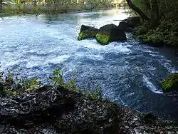 | |
| 2 | Greer Spring | Oregon County, Missouri | 360 cu ft (10 m3)[4] | 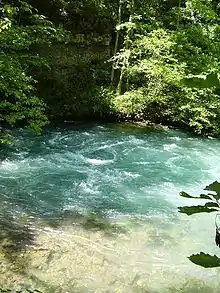 | |
| 3 | Mammoth Spring | Fulton County, Arkansas | 347 cu ft (9.8 m3)[5] | .JPG.webp) | |
| 4 | Bennett Spring | Dallas County, Missouri | 185 cu ft (5.2 m3)[6] | ||
| 5 | Double Spring | Ozark County, Missouri | 154.7 cu ft (4.38 m3)[7] | ||
| 6 | Maramec Spring | Phelps County, Missouri | 148.5 cu ft (4.21 m3)[7] | 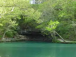 |
|
| 7 | Blue Spring | Shannon County, Missouri | 139.3 cu ft (3.94 m3)[7] | ||
| 8 | Alley Spring | Shannon County, Missouri | 125.3 cu ft (3.55 m3)[7] | ||
| 9 | Welch Spring | Shannon County, Missouri | 116 cu ft (3.3 m3)[7] | ||
| 10 | Boiling Spring | Pulaski County, Missouri | 105.3 cu ft (2.98 m3)[7] | ||
| Second magnitude 10 to 100 ft³/s[8] | |||||
| 11 | North Fork Spring | Ozark County, Missouri | 71.4 cu ft (2.02 m3)[9] | ||
| 12 | Blue Spring | Oregon County, Missouri | 71.9 cu ft (2.04 m3)[10] | ||
| 13 | Montauk Spring | Dent County, Missouri | 82.0 cu ft (2.32 m3)[11] | ||
| 14 | Hahatonka Spring | Camden County, Missouri | 74.3 cu ft (2.10 m3)[7] | ||
| 15 | Roubidoux Spring | Pulaski County, Missouri | 58.3 cu ft (1.65 m3)[12] | ||
| 16 | Blue Spring (inundated by Lake Wappapello) |
Wayne County, Missouri | 54.8 cu ft (1.55 m3)[13] | ||
| 17 | Round Spring | Shannon County, Missouri | 40 cu ft (1.1 m3)[14] | ||
| 18 | Pulltight Spring | Shannon County, Missouri | 45.5 cu ft (1.29 m3)[11] | ||
| 19 | Roaring River Spring | Barry County, Missouri | 31 cu ft (0.88 m3)[14] | ||
| 19 | Cave Spring | Shannon County, Missouri | 32.4 cu ft (0.92 m3)[10] | ||
| Third magnitude 1 to 10 ft³/s[15] | |||||
See also
- List of Missouri rivers
- List of Arkansas rivers
- Karst spring
- Spring
Notes
- USGS Annual Water Statistics
- Some sources give million gallons per day, which is equivalent to 1.547229 ft³/s.
- USGS Surface Water data for US – Big Spring 1981-2009
- USGS Surface Water data for US - Greer Spring 1981-2009
- USGS Surface Water data for US – Mammoth Spring 1981-2009
- USGS Surface Water data for US – Bennett Spring
- Vineyard, Jerry D.; Fender, Gerald L. (1982) [1974]. Springs of Missouri (PDF). Missouri Department of Natural Resources, Division of Geology and Land Survey. p. 12. Library of Congress Card Catalog No. 73-620125. Retrieved 2009-08-18.
- Some second magnitude springs could be considered first magnitude, and vice versa, depending on the data used. This list includes only some of the larger second order springs.
- Vineyard and Fender, 1982. p. 132
- Vineyard and Fender, 1982. p. 57
- Mike Gossett (February 2000). "Ozark Springs – Jewels of the Ozarks". National Park Service. Retrieved 2009-08-18.
- Blanc, Todd J. (May 2001). "Gasconade River Watersed Inventory and Assessment". Missouri Department of Conservation. Archived from the original on 2009-11-05. Cite journal requires
|journal=(help) - Beckman, H. C.; Hinchey, N. S. (1944). The Large Springs of Missouri. Rolla: Missouri Geological Survey and Water Resources. pp. 60–61.
- Vineyard and Fender, 1982. p. 168
- The number of third magnitude springs in the Ozarks numbers in the thousands.
References
- Springs of Missouri, Vineyard and Feder, Missouri Department of Natural Resources, Division of Geology and Land Survey in cooperation with U.S. Geological Survey and Missouri Department of Conservation, 1982
This article is issued from Wikipedia. The text is licensed under Creative Commons - Attribution - Sharealike. Additional terms may apply for the media files.