Roubidoux Spring
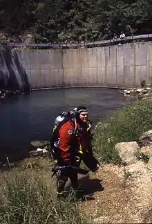
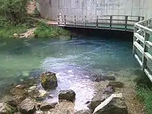
Roubidoux Spring is a second magnitude freshwater spring located within the city limits of Waynesville in the Missouri Ozarks. The spring discharges from the base of a rock ledge that has been capped by a large concrete wall, built to hold the road that passes over the spring. Spring water flows a very short distance before adding its waters to the Roubidoux Creek. A city park with trails and a board walk has been developed around the spring. This spring is noted as having an average discharge of 58.3 ft³/s.[1] However, due to very limited discharge data, an accurate description of the flow of this particular spring may be difficult to find. This could be a first magnitude spring – over 100 ft³/s. According to some lists, this ranks as the 15th largest spring in the state[2]. The area near this spring has very intense karst topography, many caves, springs and large sink holes are present within a few miles of this spring.
| Roubidoux Spring | |
|---|---|
 A hill top view of the spring | |
| Location | |
| Country | United States |
| State | Missouri |
| Region | Ozark Plateau |
| Physical characteristics | |
| Source | Roubidoux Creek watershed |
| • location | Salem Plateau, Ozark Plateau, Missouri |
| Mouth | Roubidoux Creek |
• location | near Waynesville, Pulaski County, Ozark Plateau, Missouri |
| Length | 0.01 mi (0.016 km) |
| Discharge | |
| • location | Roubidoux Springest |
| • average | 58 cu ft/s (1.6 m3/s)est |
References
- Vineyard, Jerry D.; Feder, Gerald L. (1982) [1974]. Springs of Missouri (PDF). Missouri Department of Natural Resources, Division of Geology and Land Survey. Library of Congress Card Catalog No. 73-620125.
Notes
- Vineyard, J.D., and Feder, G.L., 1982, Springs of Missouri: Missouri Geological Survey and Water Resources, Water Resources Report 29, p. 94
- List of Ozark springs
| Wikimedia Commons has media related to Roubidoux Spring. |