List of crossings of the Puyallup River
This is a list of bridges and other crossings of the Puyallup River from Puget Sound upstream to its source, the Puyallup Glacier on Mount Rainier.
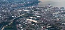
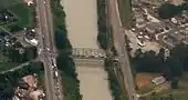
Aerial photo of Lower Puyallup River crossings in City of Tacoma (Interstate 5 near lower left corner, Commencement Bay in upper right)
Crossings
| Photo | Crossing | River mile | Carries | Location | Coordinates |
|---|---|---|---|---|---|
| Puyallup Waterway Bridge / East 11th Street Bridge[1] | East 11th Street (until July 2014)[2] | Tacoma, Washington | 47.2601°N 122.4188°W | ||
| Unnamed pipeline crossing | 0.8[3] | Sewer pipeline? | Tacoma, Washington | 47.2499°N 122.4144°W | |
 |
Lincoln Avenue Bridge[4] | Lincoln Avenue | Tacoma, Washington | 47°15′00″N 122°24′51″W | |
 |
SR 509 Bridge | Washington State Route 509[5] | Tacoma, Washington | 47°14′45″N 122°24′31″W | |
 |
BNSF Puyallup River bridge[6] (below Eells St Bridge) | BNSF Railroad | Tacoma, Washington | 47.2442°N 122.4067°W | |
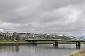
| Eells Street Viaduct/Puyallup Avenue Bridge[7][8] (center of image) | Eells Street | Tacoma, Washington | 47.243°N 122.405°W | ||
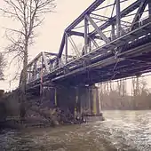
| Old Milwaukee Road Bridge[9] (above Eells St Bridge) | Tacoma Rail line, former Milwaukee Road[10] | Tacoma, Washington | 47.242°N 122.403°W | ||
| Interstate 5 Puyallup River Bridge[11] | Interstate 5 | Tacoma, Washington | 47°14′27″N 122°24′01″W | ||
| Union Pacific Puyallup River Bridge[12] | Union Pacific Railroad | Tacoma, Washington | 47.239°N 122.397°W | ||
 |
George Milroy Bridge[13] | 66th Ave E | Fife, Washington | 47.214°N 122.341°W | |
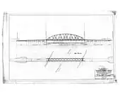 |
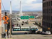
Meridian Street Bridge (SR 167 Puyallup River Bridge)[14][15] (old 1925–2015 bridge shown) | Washington State Route 161/Washington State Route 167 | Puyallup, Washington | 47.203°N 122.294°W | |
| Veterans Memorial Bridge (Milwaukee Bridge)[16] | Milwaukee Ave | Puyallup | 47.199°N 122.287°W | ||
| Washington State Route 512 | Puyallup | 47.194°N 122.283°W | |||
| East Main Street | Puyallup | 47.197°N 122.251°W | |||
 |
BNSF bridge | BNSF railroad, Amtrak | Puyallup | 47.197°N 122.250°W | |
| Washington State Route 162 | South Hill, Washington | 47.185°N 122.229°W | |||
| 96th Street East | Near Puyallup | 47.170°N 122.216°W | |||
| Colburn–McCutcheon Road | Near South Hill, Washington | 47.140°N 122.227°W | |||
| Tacoma Water pipeline bridge | Tacoma Water pipeline #2[17] | Near South Hill, Washington | 47.1399°N 122.2267°W | ||
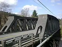 |
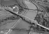
McMillin Bridge | Washington State Route 162 | South Hill, Washington | 47.1302°N 122.2353°W | |
| Calistoga Street | Orting, Washington | 47.089°N 122.214°W | |||
| Kapowsin Road Bridge | Orville Road | Near Graham, Washington | 47.039°N 122.206°W | ||
| Unnamed bridge | Private gravel mine road? | Near Graham, Washington | 47.000°N 122.192°W | ||
| Puyallup River Canyon (RM 21–26 )[lower-alpha 1] | |||||
| Electron Diversion Dam (Electron Hydroelectric Project)[19] | N/A | Near Electron, Washington | 46°54′23″N 122°02′22″W | ||
| Unnamed private bridge | Electron diversion dam access road (private) | Near Electron, Washington | 46.903°N 122.035°W | ||
| Unnamed bridge | Hancock Forest Management 2-to-7 connector road[20] | Kapowsin Timberlands, above Mowich River near Mount Rainier National Park | 46.885°N 122.006°W | ||
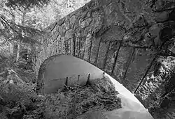 |
South Puyallup River Bridge | Westside Road | Mount Rainier National Park | 46.808°N 121.891°W | |
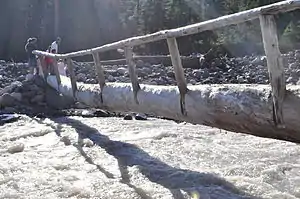 |
Wonderland Trail single-log bridge (Nisqually River shown) | c. 43 | Wonderland Trail | Mount Rainier National Park | 46.8126°N 121.8688°W |
|
Puyallup Glacier (North Puyallup River) | |||||
See also
 Transport portal
 Engineering portal
 United States portal
- List of crossings of the Columbia River
Notes
- Location of Puyallup River Canyon PRKM 27–35 from Czuba et al.[18]
References
- "Puyallup Waterway Bridge", Bridgehunter.com, BH 34459
- Kate Martin (July 1, 2014), "Safety concerns prompt Tacoma to close Tideflats bridge: The City of Tacoma is closing a 103-year-old bridge on the Tideflats to all traffic in a few weeks.", Tacoma News-Tribune
- Griffes, P.L. (2004), Pacific Boating Almanac 2004: Pacific Northwest, Prostar Publications, p. 304, ISBN 978-1-57785-500-2, retrieved October 20, 2015
- U.S. Geological Survey Geographic Names Information System: East Lincoln Avenue Bridge
- U.S. Geological Survey Geographic Names Information System: Puyallup Avenue (sic) Bridge State Highway 509
- "BNSF Puyallup River bridge", Bridgehunter.com, BH 47981
- "Puyallup Avenue Bridge", Bridgehunter.com, BH 34454
- Puyallup Avenue Bridge, HistoryLink
- "TRMW - Puyallup River Bridge", Bridgehunter.com, BH 47982
- John Caldbick (January 7, 2015), Milwaukee Road's S-Turn Trestle (Tacoma), HistoryLink
- U.S. Geological Survey Geographic Names Information System: Puyallup Avenue (sic) Bridge Interstate 5
- "UP - Puyallup River Bridge", Bridgehunter.com, BH 48276
- "George Milroy Bridge", Bridgehunter.com
- Puyallup River/ Meridian Street Bridge project overview, Washington State Department of Transportation
- SR 167 - Puyallup River Bridge replacement project, Washington State Department of Transportation, October 2015, retrieved October 21, 2015
- "Archived copy". Archived from the original on March 19, 2015. Retrieved October 19, 2015.CS1 maint: archived copy as title (link)
- "Figure 2-1 Vicinity Map", Green River Watershed Management Plan (Volume 2), Tacoma Water/Tacoma Public Utilities, p. 2–6, June 2006
- Czuba et al. 2012, p. 13.
- U.S. Geological Survey Geographic Names Information System: Electron diversion dam
- Kapowsin Timberlands Vicinity Map, Hancock Forest Management
Books
- Czuba, Jonathan A.; Magirl, Christopher S.; Czuba, Christina R.; Johnson, Kenneth H.; Olsen, Theresa D.; Curran, Christopher A.; Kimball, Halley K.; Gish, Casey C. (2012), Geomorphic Analysis of the River Response to Sedimentation Downstream of Mount Rainier, Washington, U.S. Geological Survey Open-File Report, U.S. Department of the Interior, U.S. Geological Survey, Open File Report 2012-1242, retrieved October 23, 2015
Further reading
External links
| Wikimedia Commons has media related to Bridges over the Puyallup River. |
- Pierce County bridges at uglybridges.com
This article is issued from Wikipedia. The text is licensed under Creative Commons - Attribution - Sharealike. Additional terms may apply for the media files.