Puyallup, Washington
Puyallup (/pjuːˈæləp/ (![]() listen) pew-AL-əp or /pjuːˈɔːləp/ pew-AWL-əp) is a city in Pierce County, Washington, United States, located about 10 miles (16 km) southeast of Tacoma[7] and 35 miles (56 km) south of Seattle.[8] It had a population of 37,022 at the 2010 Census, with the Washington State Office of Financial Management estimating an increase to 42,361 as of 2019.[9] The city's name comes from the Puyallup Tribe of Native Americans and means "the generous people". Puyallup is also home to the Washington State Fair, the state's largest fair.
listen) pew-AL-əp or /pjuːˈɔːləp/ pew-AWL-əp) is a city in Pierce County, Washington, United States, located about 10 miles (16 km) southeast of Tacoma[7] and 35 miles (56 km) south of Seattle.[8] It had a population of 37,022 at the 2010 Census, with the Washington State Office of Financial Management estimating an increase to 42,361 as of 2019.[9] The city's name comes from the Puyallup Tribe of Native Americans and means "the generous people". Puyallup is also home to the Washington State Fair, the state's largest fair.
Puyallup, Washington | |
|---|---|
 Flag  Seal | |
| Nickname(s): | |
| Motto(s): "Working To Be Your Community of Choice" | |
 Location of Puyallup, Washington | |
 Puyallup Location of Puyallup, Washington  Puyallup Puyallup (the United States) | |
| Coordinates: 47°10′33″N 122°17′37″W | |
| Country | United States |
| State | Washington |
| County | Pierce |
| Named for | Puyallup tribe |
| Area | |
| • Total | 14.24 sq mi (36.89 km2) |
| • Land | 14.13 sq mi (36.61 km2) |
| • Water | 0.11 sq mi (0.28 km2) |
| Elevation | 46 ft (14 m) |
| Population | |
| • Total | 37,022 |
| • Estimate (2019)[5] | 42,361 |
| • Density | 2,996.89/sq mi (1,157.07/km2) |
| Time zone | UTC-8 (Pacific (PST)) |
| • Summer (DST) | UTC-7 (PDT) |
| ZIP codes | 98371-98375 |
| Area code | 253 |
| FIPS code | 53-56695[4] |
| GNIS feature ID | 1533368[6] |
| Website | cityofpuyallup |
History
The Puyallup Valley was originally inhabited by the Puyallup people, known in their language as the spuyaləpabš, meaning "generous and welcoming behavior to all people (friends and strangers) who enter our lands."[10] The first white settlers in the region were part of the first wagon train to cross the Cascade Range at Naches Pass in 1853.[11]
Native Americans numbered about 2,000 in what is now the Puyallup Valley in the 1830s and 1840s. The first European settlers arrived in the 1850s. In 1877, Ezra Meeker platted a townsite and named it Puyallup after the local Puyallup Indian tribes, 11 years after departing from Indiana.[12] The town grew rapidly throughout the 1880s, in large part thanks to Meeker's hop farm, which brought in millions of dollars to Puyallup, leading to it eventually being incorporated in 1890, with Ezra Meeker as its first mayor.[13] The turn of the 20th century brought change to the valley with the growth of nearby Tacoma and the interurban rail lines. The Western Washington Fairgrounds were developed giving local farmers a place to exhibit their crops and livestock. During the early part of World War II, the fairgrounds were part of Camp Harmony, a temporary Japanese American internment camp for more than 7,000 detainees, most of whom were American citizens. Subsequently, they were moved to the Minidoka relocation center near Twin Falls, Idaho.[14]
Geography
Puyallup is located at 47°10′33″N 122°17′37″W (47.1757,-122.2936).[15]
According to the United States Census Bureau, the city has a total area of 14.04 square miles (36.36 km2), of which 13.93 square miles (36.08 km2) is land and 0.11 square miles (0.28 km2) is water, mainly consisting of the Puyallup River estuary.[16]
Puyallup is 12.2 mi2 (31.6 km2). As it is bordered largely by unincorporated Pierce County, the closest neighbors include the city of Sumner to the northeast, Fife and Edgewood to the north, Tacoma to the northwest, Summit and Midland to the west, South Hill, Graham and Frederickson to the south, McMillin and Orting to the southeast, and Alderton to the east.
Downtown and the valley neighborhoods of Puyallup would likely be damaged or destroyed in a moderate or large eruption of nearby Mount Rainier.
Climate
Puyallup experiences an oceanic climate (Köppen classification: Csb; Trewartha classification: Do). Winters are cool and wet, with high temperatures averaging in the mid to upper 40s and lows near freezing. The surrounding hills (averaging 500 feet (150 m) above sea level) often experience the extremes of winter, with more frequent lows below freezing and greater snowfall. Snowfall is rare, and often only occurs on a few days a year, sometimes as early as November, and as late as April. Spring brings less rain and milder temperatures, with highs regularly in the mid 50s (12–14 °C), to around 60 (15 °C). Spring often records the first 70 °F (21 °C) temperature. Summers are warm and dry, with highs in the 70s most days. Many days can max out in the 80s, and occasionally the 90s. Readings above 100 °F (37.7 °C) are very rare; on July 29, 2009, during a prolonged period of hot weather, Puyallup recorded a temperature of 105 °F (40.5 °C), the warmest since records have been kept. Summer thunderstorms happen occasionally, but are often isolated and rarely (if ever) severe. Storms often roll off the Cascades and into the surrounding areas; they are usually a result of warm moist air from monsoons in the southwestern United States. Summer is warmest in July and August, and occasionally September. By October and the fall season, temperatures start to drop and precipitation increases.
Demographics
| Historical population | |||
|---|---|---|---|
| Census | Pop. | %± | |
| 1870 | 312 | — | |
| 1880 | 297 | −4.8% | |
| 1890 | 1,732 | 483.2% | |
| 1900 | 1,884 | 8.8% | |
| 1910 | 4,544 | 141.2% | |
| 1920 | 6,323 | 39.2% | |
| 1930 | 7,094 | 12.2% | |
| 1940 | 7,889 | 11.2% | |
| 1950 | 10,010 | 26.9% | |
| 1960 | 12,063 | 20.5% | |
| 1970 | 14,742 | 22.2% | |
| 1980 | 18,251 | 23.8% | |
| 1990 | 23,875 | 30.8% | |
| 2000 | 33,011 | 38.3% | |
| 2010 | 37,022 | 12.2% | |
| 2019 (est.) | 42,361 | [5] | 14.4% |
2010 census
As of the census[4] of 2010, there were 37,022 people, 14,950 households, and 9,528 families residing in the city. The population density was 2,657.7 inhabitants per square mile (1,026.1/km2). There were 16,171 housing units at an average density of 1,160.9 per square mile (448.2/km2). The racial makeup of the city was 84.4% White, 2.1% African American, 1.4% Native American, 3.8% Asian, 0.7% Pacific Islander, 2.1% from other races, and 5.5% from two or more races. Hispanic or Latino of any race were 6.9% of the population.
There were 14,950 households, of which 32.8% had children under age 18 living with them, 45.8% were married couples living together, 12.8% had a female householder with no husband present, 5.1% had a male householder with no wife present, and 36.3% were non-families. 28.5% of all households were made up of individuals, and 10.7% had someone living alone who was aged 65 years or older. The average household size was 2.43 persons and the average family size was 2.98 .
The median age in the city was 36.8 years. 23.6% of residents were under age 18; 10.2% were between ages 18 and 24; 27% were from 25 to 44; 26.8% were from 45 to 64; and 12.4% were 65 years of age or older. The gender makeup of the city was 48.0% male and 52.0% female.
2000 census
As of the census[4] of 2000, there were 33,011 people, 12,870 households, and 8,519 families residing in the city. The population density was 2,719.2 people per square mile (1,049.9/km2). There were 13,467 housing units at an average density of 1,109.3 people per square mile (428.3/km2). The racial makeup of the city was 87.88% White, 1.50% African American, 1.01% Native American, 3.27% Asian, 0.34% Pacific Islander, 1.94% from other races, and 4.06% from two or more races. Hispanic or Latino of any race were 4.67% of the population.
There were 12,870 households, out of which 36.0% had children under the age of 18 living with them, 49.7% were married couples living together, 11.7% had a female householder with no husband present, and 33.8% were non-families. 26.9% of all households were made up of individuals, 9.5% of which were 65 years of age or older. The average household size was 2.53 and the average family size was 3.08 .
In the city, the age distribution of the population shows 27.3% under the age of 18, 10.2% from 18 to 24, 30.8% from 25 to 44, 20.8% from 45 to 64, and 10.9% who were 65 years of age or older. The median age was 34 years. For every 100 females, there were 93.5 males. For every 100 females age 18 and over, there were 90.9 males.
The median income for a household in the city was $47,269, and the median income for a family was $57,322. Males had a median income of $43,562 versus $27,281 for females. The per capita income for the city was $22,401. About 4.7% of families and 6.7% of the population were below the poverty line, including 7.2% of those under age 18 and 6.5% of those age 65 or over.
Culture
Puyallup valley
The valley in which Puyallup was originally settled forms the town. Its fertile soil is optimal for the acres of daffodils which were grown for distribution worldwide, and are featured in the town's annual spring parade. The Puyallup River meanders between the hills, through the glacial basin, from its namesake glacier on Mt. Rainier, terminating in Puget Sound at the Port of Tacoma. It is cold, silty, and brown, sometimes green. From most perspectives in the town of Puyallup, Mt. Rainier is visible to the southeast.
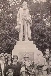
Downtown Puyallup has several notable landmarks, including Ezra Meeker's mansion, which was built and inhabited by one of the town's founding families, who made their way to Puyallup via the Oregon trail. The downtown shopping district is made up of historic buildings, which date to the town's origin. Pioneer Park is a community focal point, which boasts a public library, a park with a playground, and walking paths. As the focal point of the park, there is a bronze statue honoring Ezra Meeker. A new element is the public stage by the public library. At the public stage local musicians put on free shows for the public. Southeast Puyallup is also where the Pierce County Foothills Trail begins.
Ezra Meeker's mansion
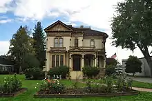
The Ezra Meeker Mansion is an Italianate Victorian building completed around 1890, which was the home of Oregon Trail pioneer Ezra Meeker and his wife Eliza Jane. Known as the “Hop King”, Meeker ultimately lost a fortune due to a disease in the hops. He became well known for tracking the Oregon Trail over the years and erecting monuments along its course in an effort to memorialize it. The mansion functions today as a small house museum owned and operated by the Puyallup Historical Society at Meeker Mansion (formerly the Ezra Meeker Historical Society). The building can also be rented out for weddings, teas and other social events.[18]
Washington State Fair
Puyallup is home to the Washington State Fair. It is one of the ten largest U.S. state fairs, attracting over one million people each year. The city itself is built around the Puyallup Fairgrounds, which can be seen prominently from neighboring South Hill. The fair traditionally runs for 21 days in September; there is also a "Spring Fair" which takes place for four days in April. The fair serves as an anchor for local businesses and restaurants. Previously named the "Puyallup Fair", it received its current name in 2013. "Do the Puyallup" has been its long-standing promotional slogan.
During World War II, the Puyallup Fairgrounds became the Puyallup Assembly Area (euphemistically referred to as "Camp Harmony") and were used as an internment camp for United States citizens or residents of Japanese descent or origin.[19]
Daffodil Festival parade
Puyallup also hosts and is origin of the annual four-part Daffodil Parade, which takes place every year in Tacoma, Puyallup, Sumner, and Orting.
The parade includes many groups and has many floats, most of which are covered in daffodils, or are themed in the daffodil season. Most of the local junior high and high school marching bands also march. Car clubs, veteran groups and also some businesses are a part of the parade.
Antique district
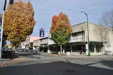
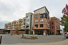
Puyallup is known for its myriad antiques stores, many of which are located next to each other on the main north-south street of Meridian. Puyallup is one of many cities and towns in Washington that contains an 'old-fashioned' downtown shopping area.
Paul H. Karshner Memorial Museum
The Karshner Museum is the only K–12 teaching museum owned and operated by a school district west of the Mississippi. The essential education and curriculum-based program serves the Puyallup School District's 20,000 K–12 student population. Since 1930, the Karshner Museum has provided hands-on and curriculum-based learning experiences to thousands of students through the museum visit program. The education trunk or "Discovery Kit" program has served students, teachers and community members since the 1970s. These Kits utilize real or replica artifacts for the purposes of bringing history, art and culture to life in the school classroom.
Arts Downtown outdoor gallery
Starting in 1995, the regional nonprofit organization Valley Arts United began working with local volunteers to support a rotating selection of outdoor public artwork. Consisting mostly of statuary dispersed about the downtown core, this collection has grown to a collection of about 32 permanent pieces. New works are added regularly.[20]
Farmers' market

The Puyallup Main Street Association produces the Puyallup Farmers' Market each year. The market is open Saturdays (9 a.m. to 2 p.m.) from mid-April to mid-October, with a Holiday Market in December (together with the lighted Santa Parade – first Saturday of December). Puyallup Farmers' Market is the largest market in Pierce County and one of the largest in the state. Thousands of people come each week to purchase produce, plants and seeds, flowers, baked goods, meats and cheese, food, local handcrafts, and more. Free live entertainment. The market fills Pioneer Park and the modern pavilion building, and takes over Elm and 4th streets.
Education
The Puyallup School District has over 30 schools attended by more than 20,000 students. The district is the ninth largest in Washington state, extending to neighboring South Hill, parts of Tacoma, and the Edgewood area.[21] Some local schools hold annual warning drills on account of the dangers of lahars in the event of an eruption of Mount Rainier, which would leave students with a maximum of 15 minutes to find higher land or the top of a building.[22][23]
Puyallup is also home to Pierce College Puyallup, a community college that opened in 1990. It is one of the two main campuses belonging to the college, the other being Pierce College Fort Steilacoom in Lakewood.
The city is served by the Puyallup Public Library, which was established in 1913 and has been housed in its current building in Pioneer Park since 2002. It is not affiliated with either the Tacoma Public Library or the Pierce County Library System.
Media
The Herald is the local newspaper for eastern Pierce County. It is published once a week on Wednesdays. The paper is distributed by The News Tribune.[24]
Transportation
Puyallup is located at the intersection of State Route 167 and State Route 512, with freeway access to Lakewood and the Green River Valley. The city is also served by Pierce Transit buses and Sounder commuter rail at Puyallup station.
The city is located near the Pierce County Airport (KPLU), a small municipal airport in South Hill.
Notable residents
- Zach Banner (born 1993), American NFL football offensive tackle for the Pittsburgh Steelers
- Frank Brouillet, former Washington State Superintendent of Public Instruction, Member of Washington State House of Reps, Educator
- Gail Bruce, former American football player
- Army Sergeant First Class Nathan Chapman, First US combat casualty of Operation Enduring Freedom[25]
- Army Major General Chester Victor Clifton Jr.
- Amber Cope, Former NASCAR Driver
- Natasha Curry, news anchor at CNN Headline News
- Zach Davies, pitcher currently playing for the Milwaukee Brewers[26]
- Chris Egan, nine-time Emmy award-winning television sports reporter/anchor for KING-TV
- Brandon Gibson, American football player
- Harriet A. Hall, medical columnist and Alternative medicine critic[27]
- Nick Harmer, bassist for Death Cab for Cutie
- Teri Hickel, state representative
- Brock Huard, sports talk show host, former NFL and college quarterback
- Megan Jendrick, Olympic swimmer[28]
- Demetrious Johnson, UFC Flyweight fighter
- Dustin-Leigh Konzelman, Miss California (2005) and Amazing Race contestant
- Jon Lester, pitcher for the Chicago Cubs
- Angela Rasmussen, virologist
- Angela Ruch, NASCAR Gander RV & Outdoors Truck Series Driver
- Kelly Sullivan, actress[29]
- Gertrude Wilhelmsen, Olympic athlete[30]
- Soyeon Yi, South Korean astronaut[31]
- Natasha Curry, New Anchor for CNN
References
- "Welcome to Pierceland, Pam Roach – let the berating begin!". The News Tribune. 4 January 2017.
Bow down to P-town: Whatever happens in Pierceland in the new political season, it’s plain that Puyallup is in charge, and Tacoma can learn to love scones.
- "Night Moves: Hive Dwellers, Daniel Blue, Keith Sweat, SweetKiss Momma, and others". Weekly Volcano. 19 November 2010.
the best thing P-Town has going for it these days
- "2019 U.S. Gazetteer Files". United States Census Bureau. Retrieved August 7, 2020.
- "U.S. Census website". United States Census Bureau. Retrieved 19 December 2012.
- "Annual Estimates of the Resident Population for Incorporated Places in Washington: April 1, 2010 to July 1, 2019". United States Census Bureau. May 2020. Retrieved May 27, 2020.
- "US Board on Geographic Names". United States Geological Survey. 25 October 2007. Retrieved 31 January 2008.
- "Google Maps".
- "Google Maps".
- "Annual Estimates of the Resident Population for Incorporated Places in Washington: April 1, 2010 to July 1, 2019". United States Census Bureau, Population Division. Retrieved May 26, 2020.
- "Puyallup Tribal History". Puyallup Tribe. Retrieved September 27, 2020.
- "Puyallup, Washington – Living in the City of Puyallup". puyallup.com.
- Meeker, Ezra (1909). Ventures and Adventures of Ezra Meeker: Or, Sixty years of frontier life; fifty-six years of pioneer life in the old Oregon Country; an account of the author's trip across the plains with an ox team in 1852, and his return trip in 1906; his cruise on Puget Sound in 1853, and his trip through the Natchess Pass in 1854; over the Chilcoot Pass and flat-boating on the Yukon in 1898. The Oregon Trail. Rainier Printing.
- "Ezra's History". Meeker Mansion. Puyallup Historical Society. Retrieved 27 February 2019.
- "The Land of the Generous People: History". The City of Puyallup. 14 January 2010.
- "Google Maps". Retrieved 5 January 2009.
- "U.S. Gazetteer files 2010". United States Census Bureau. Archived from the original on 1 June 2012. Retrieved 19 December 2012.
- "Census of Population and Housing". Census.gov. Retrieved June 4, 2016.
- "Meeker Mansion". meekermansion.org.
- "Camp Harmony exhibit". U.W. Library. University of Washington.
- "Valley Arts United". valleyartsunited.org.
- "Overview of Puyallup School District". puyallup.k12.wa.us.
- Horcher, Gary (June 4, 2018). "UW professor: Deadly Guatemala lahar could happen here". KIRO 7 News.
... lahar warning drills in school for four years ...
- "More than 5,500 students and staff practice safety in Lahar drill". news archives. Puyallup School District. September 30, 2014.
... Participating schools included Puyallup and Walker high schools, Kalles and Aylen junior high schools, and Stewart, Spinning, Shaw Road, Meeker, Maplewood, and Karshner elementary schools ...
- "About the Puyallup Herald". puyallup-herald.com.
- "State of the Union guests". WhiteHouse.gov (archived). U.S. National Archives. 2002. Retrieved 10 March 2008.
- "Zach Davies". MILB. Retrieved 30 May 2018.
- "TRC #49: Homeopathy 101 + Harriet Hall Interview + Sex on the Mind Myth". The Reality Check podcast. Ottawa Skeptics. 1 August 2009. Retrieved 1 August 2009. (Interview from 16:08 to 33:25)
- Borzilleri, Meri-Jo (23 July 2008). "Megan Jendrick knows competitive ecstasy and agony – both by the slimmest of margins". The Seattle Times. Retrieved 30 May 2018.
- Liu, Marian (5 September 2008). "Neumo's show has rap, bluegrass, gospel, ... and success". The Seattle Times. Retrieved 30 May 2018.
- "Gertrude Wilhelmsen Bio, Stats and Results". Sports Reference LLC. Archived from the original on 18 April 2020. Retrieved 16 November 2015.
- Plog, Kari (21 August 2014). "South Korea's first astronaut lands in Puyallup to settle down". The News Tribune. Retrieved 27 April 2018.
Further reading
- Rodriguez, Ismael, Jr. (May 2020). "We Wanted Them to be Educational". VFW Magazine. Vol. 107 no. 8. Kansas City, Mo.: Veterans of Foreign Wars of the United States. p. 46. ISSN 0161-8598.
A VFW Post in Washington state raises $13,000 to build monuments for two local MOH recipients. The granite structures are located at the medal recipients' respective high schools.
External links
| Wikimedia Commons has media related to Puyallup, Washington. |
- Official website

- Puyallup, Washington at Curlie
- Puyallup, Washington at Puyallup.com
Places adjacent to Puyallup, Washington | |
|---|---|
Municipalities and communities of Pierce County, Washington, United States | ||
|---|---|---|
| Cities | 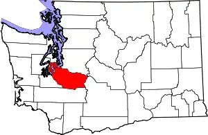 Map of Washington highlighting Pierce County | |
| Towns | ||
| CDPs |
| |
| Other unincorporated communities | ||
| Indian reservation | ||
| Military bases | ||
| Ghost towns | ||
| Footnotes | ‡This populated place also has portions in an adjacent county or counties | |
| ||
| Authority control |
|---|