List of earthquakes in South Africa
The following is a list of notable earthquakes or tremors that have been detected within South Africa.
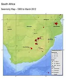
According to Professor Andrzej Kijko from the University of Pretoria's Natural Hazard Centre, mining can activate natural faults. He believes that 95% of South Africa's earthquakes are caused by mining, especially around the areas of Klerksdorp, Welkom and Carletonville. According to earth science consultant Dr Chris Hartnady, "This part of Africa is in the vicinity of the African Rift system, which is being pulled apart by a few millimetres annually." He says "earthquakes are caused by a slip on a fault line and the release of stored elastic energy" and mining activity can trigger earthquakes.[1]
Earthquake data
For earthquakes prior to the modern era, the magnitude and epicentre location are only approximate, and were calculated based on available reports from the time. The magnitude where given is measured using the Richter scale () unless stated otherwise.

20th and 21st century
| Date | Time (SAST) | Epicentre | Depth | Deaths | Notes | |
|---|---|---|---|---|---|---|
| 29 September 1969 | Near Tulbagh | 6.3 | 12 [2] | The 1969 Tulbagh earthquake remains the most destructive earthquake in South African history. The earthquake occurred in the Tulbagh area and measured 6.3 on the Richter scale, stronger than that of the 1809 Cape Town earthquake which destroyed a local Milnerton farm.[3][4] | ||
| 8 December 1976 | Welkom | 5.2 | 4 | Miners.[5] | ||
| 26 September 1990 | Welkom | 4.2 | 2[5] | |||
| 9 March 2005 | Stilfontein, North West | 5.3 | 2 | Miners were killed underground.[6][7] | ||
| 28 May 2013 | Near Mbabane | 4.0 | The earthquake was felt in Newcastle and lasted about six seconds.[8] | |||
| 22 June 2013 | 07:08 | Thabazimbi, Limpopo | 3.9 | 9 km | The earthquake was felt up in the Thabazimbi area.[9] | |
| 7 July 2013 | 16:52 | Barberton, Mpumalanga | 4.7 | 5 km | The earthquake was felt in the Barberton area.[10] | |
| 11 November 2013 | University of Johannesburg, Johannesburg, Gauteng | 4.0 | The earthquake was felt as far as parts of northern and southern Johannesburg and lasted for around 10–15 seconds.[11] | |||
| 2 December 2013 | 21:18 | ~25 km south of Bela-Bela, Limpopo | 4.8 | 5 km | The earthquake was felt as far as Parkhurst and Randburg in Johannesburg, Hartebeespoort Dam in North West, Witbank and KwaMhlanga in Mpumalanga, and Soshanguve near Pretoria.[12][13] | |
| 15 June 2014 | 18:16 | Near Orkney, North West | 4.9 MW | 5 km | The earthquake was felt up to Potchefstroom.[14] | |
| 5 August 2014 | 12:22 | Near Orkney, North West | 5.5 | 5.0 km | The earthquake was felt as far as parts of Botswana and Durban, it lasted for around 90 sec. The local Council for Geoscience measured the earthquake at 5.5 on the Richter scale, while the United States Geological Survey recorded a moment magnitude of 5.4.[15][16][17][18] | |
| 22 August 2014 | 1:14 | Near Orange Farm, Gauteng | 3.8 | 10 km | The second earthquake in South Africa in less than three weeks.[19] No reports of injuries.[20]
The Council for Geoscience (CGS) in South Africa reported an earthquake of 3.8 with two aftershocks occurring within minutes of each other of 3.2 and 2.0 respectively.[21] | |
| 31 October 2019 | 13:20 | Near Port Shepstone, KwaZulu-Natal | 4.3 | 10 km | The Council for Geoscience (CGS) in South Africa reported an earthquake of a preliminary value of 3.7 on the local magnitude scale. However, the US Geological Survey (USGS) has it logged as 4.3[22][23] | |
| 26 September 2020 | 19:10 | 1600 km SE of South Africa | 6.1 | 10 km | US Geological Survey (USGS) report.[24]
Mistakenly reported to have been felt in Cape Town. See below earthquake. | |
| 26 September 2020 | 20:41 | 12 km W of Paarl, South Africa | 2.7 | 5 km | Felt by residents in Cape Town area. Council for Geoscience (CGS) in South Africa report.[25] US Geological Survey (USGS) report.[26] | |
| 27 September 2020 | 09:12 | Durbanville Area, Cape Town | 2.6 | 5 km | Felt by residents in Cape Town area. Council for Geoscience (CGS) in South Africa report.[27] US Geological Survey (USGS) report. [28] | |
| 17 November 2020 | 00:27 | 41 km S of Saldanha, South Africa | 3.5 | 5km | Felt by residents in Cape Town area. Council for Geoscience (CGS) in South Africa report.[29] US Geological Survey (USGS) report. [30] |
See also
References
- Hosken, Graeme; Smillie, Shaun; Child, Katharine; Louw, Poppy; Masombuka, Sipho (6 August 2014). "Quake of shaky things to come". Times LIVE. Archived from the original on 15 August 2014. Retrieved 6 August 2014.
- Durrheim, Ray (15 October 2019). "50 years on: What we learned from South Africa's biggest quake". University of the Witwatersrand. Retrieved 16 November 2020.
- Shevel, Adele (10 August 2014). "Insurers brace for a wave of quake claims". Business Day. Archived from the original on 15 August 2014. Retrieved 15 August 2014.
- "Ceres earthquake". 9 March 2014. Archived from the original on 27 April 2012. Retrieved 9 March 2014.
- Seale, Lebogang (14 August 2014). "Quake triggered by mine activity – expert". The Star. Archived from the original on 14 August 2014. Retrieved 14 August 2014.
- "Media Update: 5.5 magnitude earthquake – tremors continue". Council for Geoscience. Archived from the original on 15 August 2014. Retrieved 14 August 2014.
- le Cordeur, Matthew (6 August 2014). "Did mining cause SA quake?". Fin24. Archived from the original on 14 August 2014. Retrieved 14 August 2014.
- "Tremor hits northern KZN". IOL. 29 May 2012. Retrieved 4 December 2013.
- "3.9 magnitude earthquake 15 km from Thabazimbi, Limpopo, South Africa". Earthquake Track. 22 June 2013. Retrieved 22 June 2013.
- "4.7 magnitude earthquake 49 km from Barberton, Mpumalanga, South Africa". Earthquake Track. 7 July 2013. Retrieved 7 July 2013.
- "Earth tremor felt in Joburg". IOL. 18 November 2013. Retrieved 4 December 2013.
- "Tremor strikes near Bela Bela". IOL. 3 December 2013. Retrieved 4 December 2013.
- "4.8 magnitude earthquake 40 km from Siyabuswa, Mpumalanga, South Africa". Earthquake Track. 2 December 2013. Retrieved 2 December 2013.
- "4.9 magnitude earthquake 7 km from Orkney, North-West, South Africa". Earthquake Track. 15 June 2014. Retrieved 15 June 2014.
- Tempelhoff, Elise; Cilliers, Susan (6 August 2014). "Só skeur Afrika (stadig) in twee" [Thus Africa tears (slowly) in two]. Beeld (in Afrikaans). Retrieved 6 August 2014.
- "Aardbewing van 5.3 ruk SA, berigte van skade (twiets)" [Earthquake of 5.3 shakes SA, reports of damage (tweets)]. Beeld (in Afrikaans). 5 August 2014. Retrieved 5 August 2014.
- "M5.4 – 3km ENE of Orkney, South Africa". United States Geological Survey. Archived from the original on 8 August 2014. Retrieved 16 October 2014.
- "5.4 magnitude earthquake 4 km from Orkney, North-West, South Africa". Earthquake Track. 5 August 2014. Retrieved 14 August 2014.
- "4.6 magnitude earthquake hits west of Orange Farm". 22 August 2014.
- "No injuries after 4.6 magnitude quake". 22 August 2014.
- "Three earthquakes hit the Carletonville area early in the morning". 22 August 2014. Archived from the original on 25 May 2015. Retrieved 22 August 2014.
- "Statement on the Seismic Event That Occurred in the KZN Area". 1 November 2019.
- "M 4.3 - 44 km NW of Port Shepstone, South Africa". 31 October 2019.
- "M 6.1 - South of Africa". earthquake.usgs.gov. Retrieved 17 November 2020.
- "CGS Earthquake Detail - M2.7 - Cape Town".
- "M 2.7 - 12 km W of Paarl, South Africa". earthquake.usgs.gov. Retrieved 17 November 2020.
- "CGS Earthquake Detail - M2.5 - Cape Town".
- "M 2.6 - 19 km ESE of Atlantis, South Africa". earthquake.usgs.gov. Retrieved 17 November 2020.
- "CGS Earthquake Detail - M3.4 Saldanha, South Africa".
- "M 3.5 - 41 km S of Saldanha, South Africa". earthquake.usgs.gov. Retrieved 17 November 2020.