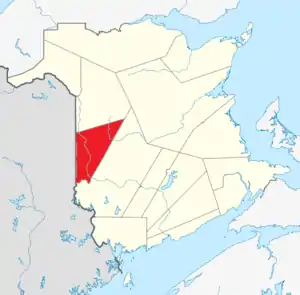
List of historic places in Carleton County, New Brunswick
This article is a list of historic places in Carleton County, New Brunswick entered on the Canadian Register of Historic Places, whether they are federal, provincial, or municipal.
List of historic places
| Name | Address | Coordinates | IDF | IDP | IDM | Image | |
|---|---|---|---|---|---|---|---|
| Armoury | Chapel Street, Woodstock, NB | 46°09′05″N 67°34′25″W | 4342 |  | |||
| Bennett House | 698 Main Street, Woodstock, NB | 46°09′10″N 67°34′21″W | 9956 | | |||
| Bristol Shogomoc Railway Site | 9189 Main St., Bristol, NB | 46°28′22″N 67°34′45″W | 9674 | | |||
| Cambridge Street | Cambridge Street, Woodstock, NB | 46°09′29″N 67°34′33″W | 8543 | | |||
| 115 Cambridge Street | 115 Cambridge Street, Woodstock, NB | 46°09′28″N 67°34′32″W | 8640 | | |||
| Capitol Building | 114 Queen Street, Woodstock, NB | 46°08′59″N 67°34′21″W | 8613 | | |||
| Carleton County Courthouse | 689 Main Street, Woodstock, NB | 46°09′08″N 67°34′22″W | 5427 | | |||
| Carleton County Jail | 108 Maple Street, Woodstock, NB | 46°09′08″N 67°34′24″W | 5316 | | |||
| Judge Carleton House | 117 Union Street, Woodstock, NB | 46°08′40″N 67°34′38″W | 8503 | | |||
| Carleton Lodge No. 41 Independent Order of Oddfellows Hall | 115 St. James Street, Woodstock, NB | 46°09′23″N 67°34′33″W | 8545 | | |||
| 119 Chapel Street | 119 Chapel Street, Woodstock, NB | 46°09′06″N 67°34′32″W | 5623 | | |||
| 149 Chapel Street | 149 Chapel Street, Woodstock, NB | 46°09′10″N 67°34′48″W | 5418 | | |||
| Dr. Walter Chestnut Library | 395 Main Street, Hartland, NB | 46°17′54″N 67°31′42″W | 16385 | 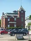 More images | |||
| Church of the Good Shepherd | 8772 Main Street, Florenceville-Bristol, NB | 46°26′35″N 67°37′07″W | 12363 | | |||
| Dr. George Frederick Clarke House | 814 Main Street, Woodstock, NB | 46°09′45″N 67°34′27″W | 10068 | 5433 | | ||
| Connell Building | 616-620 Main Street; 106 Harvey Street, Woodstock, NB | 46°08′59″N 67°34′24″W | 8575 | | |||
| Charles Connell House | 128 Connell Street, Woodstock, NB | 46°09′03″N 67°34′32″W | 11969 | 4942 | 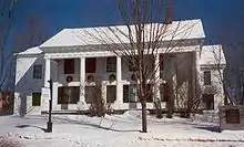 | ||
| 124 Connell Street | 124 Connell Street, Woodstock, NB | 46°09′03″N 67°34′29″W | 5417 | | |||
| 139 Connell Street | 139 Connell Street, Woodstock, NB | 46°09′03″N 67°34′37″W | 8231 | | |||
| 153 Connell Street | 153 Connell Street, Woodstock, NB | 46°09′03″N 67°34′46″W | 5524 | | |||
| District 14 School Board Office | 138 Chapel Street, Woodstock, NB | 46°09′09″N 67°34′41″W | 8589 | | |||
| Donaho House | 110 Elm Street, Woodstock, NB | 46°09′19″N 67°34′27″W | 8544 | | |||
| L. P. Fisher Public Library | 679 Main Street, Woodstock, NB | 46°09′05″N 67°34′24″W | 4943 | 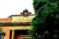 | |||
| Florenceville Bridge | Jim Davis Drive, Florenceville-Bristol, NB | 46°26′30″N 67°37′16″W | 12345 | 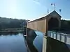 | |||
| Florenceville-Bristol Community Hall | 8696 Main Street, Florenceville-Bristol, NB | 46°26′19″N 67°37′11″W | 12366 | | |||
| Forester Hall | 344 Main Street, Hartland, NB | 46°17′46″N 67°31′33″W | 16361 | | |||
| 103 George Street | 103 George Street, Woodstock, NB | 46°08′35″N 67°34′45″W | 5435 | | |||
| Government of Canada Building | 698 Main Street, Woodstock, NB | 46°09′05″N 67°34′22″W | 9491 | | |||
| 106 Green Street | 106 Green Street, Woodstock, NB | 46°09′06″N 67°34′33″W | 5426 | | |||
| 105 Grover Street | 105 Grover Street, Woodstock, NB | 46°09′21″N 67°34′25″W | 5424 | | |||
| 105 Guelph Street | 105 Guelph Street, Woodstock, NB | 46°09′14″N 67°34′20″W | 5420 | | |||
| Hartland Covered Bridge | 31 Main Street, Hartland, NB | 46°18′00″N 67°32′00″W | 7623 | 1330 | 16366 | 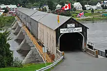 | |
| Hartland Salmon Pool | adjacent to and slightly northwest of Main Street, from the mouth of the Becaguimec River along the Saint John River) to a point just upriver from the Hartland Covered Bridge, Hartland, NB | 46°17′51″N 67°31′47″W | 16364 | | |||
| Hartland Town Hall | 31 Orser Street, Hartland, NB | 46°17′57″N 67°31′38″W | 16383 | | |||
| Holy Trinity Anglican Church | 67 Orser Street, Hartland, NB | 46°18′01″N 67°31′34″W | 16391 | | |||
| Island Park | in the waters of the Saint John River, Woodstock, NB | 46°08′46″N 67°34′02″W | 8540 | | |||
| Dr. Lorne MacIntosh Home, Office, and Hospital | 340 Main Street, Hartland, NB | 46°17′46″N 67°31′32″W | 16384 | | |||
| 484 Main Street | 484 Main Street, Woodstock, NB | 46°08′36″N 67°34′40″W | 5432 | | |||
| 623-629 Main Street | 623-629 Main Street, Woodstock, NB | 46°09′00″N 67°34′25″W | 8576 | | |||
| 702 Main Street | 702 Main Street, Woodstock, NB | 46°09′11″N 67°34′21″W | 8573 | | |||
| 712 Main Street | 712 Main Street, Woodstock, NB | 46°09′13″N 67°34′20″W | 5315 | | |||
| E. R. Marich Building | 9160 Main Street, Florenceville-Bristol, NB | 46°28′13″N 67°34′54″W | 12364 | | |||
| Andrew and Laura McCain House | 95 Riverview Drive, Florenceville-Bristol, NB | 46°26′34″N 67°37′40″W | 12362 | | |||
| McLauchlan Building | 638 Main Street, Woodstock, NB | 46°09′00″N 67°34′24″W | 8577 | | |||
| Meed's Lane | Meed's Lane, Bristol, NB | 46°28′20″N 67°34′51″W | 9672 | | |||
| Mineral Free Baptist Meetinghouse | 245 Doherty Road, Mineral, Kent Parish, NB | 46°35′23″N 67°35′44″W | 7756 | | |||
| Newnham & Slipp Pharmacy | 604 Main Street, Woodstock, NB | 46°08′57″N 67°34′24″W | 5425 | | |||
| Old Carleton County Court House | 19 Court Street, Woodstock, NB | 46°10′33″N 67°34′32″W | 5885 | 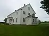 | |||
| Old Free Baptist Church | 4710 Juniper Road (Route 107), Florenceville-Bristol, NB | 46°28′17″N 67°34′31″W | 12346 | | |||
| Old Methodist Cemetery | 100 Mountain Street, Woodstock, NB | 46°08′45″N 67°34′47″W | 5429 | | |||
| Orange Riot Site | Victoria and Boyne Streets, Woodstock, NB | 46°09′13″N 67°34′25″W | 9883 | | |||
| 129 Orange Street | 129 Orange Street, Woodstock, NB | 46°09′17″N 67°34′37″W | 5419 | | |||
| Orser Burial Cemetery | Orser Street, Hartland, NB | 46°18′00″N 67°31′38″W | 16562 | | |||
| Riverside Park | 9173 Main Street, Florenceville-Bristol, NB | 46°28′17″N 67°34′52″W | 9673 | | |||
| St. David's Presbyterian Church | Route 540, Kirkland, New Brunswick, NB | 45°58′06″N 67°42′54″W | 7757 | | |||
| 101 St. James Street | 101 St. James Street, Woodstock, NB | 46°09′24″N 67°34′26″W | 8161 | | |||
| St. James United Church | 120 Chapel Street, Woodstock, NB | 46°09′07″N 67°34′32″W | 9764 | | |||
| St. Luke's Anglican Church | 104 Church Street, Woodstock, NB | 46°09′06″N 67°34′21″W | 9916 | | |||
| Shamrock Suites | 8 Curtis Hill Road, Bristol, NB | 46°28′12″N 67°34′54″W | 9758 | | |||
| Slipp House | 135 Union Street, Woodstock, NB | 46°08′36″N 67°34′44″W | 8641 | | |||
| Dr. Somerville's Office | 9133 Main St., Bristol, NB | 46°28′13″N 67°35′01″W | 9690 | | |||
| Somerville Residence | 9129 Main Street, Bristol, NB | 46°28′13″N 67°35′01″W | 9691 | | |||
| Sunder House | 117 Green Street, Woodstock, NB | 46°09′11″N 67°34′32″W | 5430 | | |||
| Trinity United Church of Canada | 346 Main Street, Hartland, NB | 46°17′47″N 67°31′33″W | 16363 | | |||
| Tupper House | 142 Connell Street, Woodstock, NB | 46°09′05″N 67°34′38″W | 8542 | | |||
| Upper Woodstock Old Tavern and Store | Route 103, Woodstock, NB | 46°10′33″N 67°34′22″W | 7820 | | |||
| 110 White Street | 110 White Street, Woodstock, NB | 46°09′08″N 67°34′56″W | 5317 | | |||
| Winslow House | 129 Union Street, Woodstock, NB | 46°08′38″N 67°34′40″W | 8541 | | |||
| Wolastoq National Historic Site of Canada | Entire watershed of Saint John River, central and western New Brunswick, parts of southeastern Quebec, NB | 46°10′18″N 67°34′03″W | 18954 | 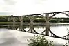 | |||
| Woodstock Golf and Curling Club | 132 St. Andrews Street, Woodstock, NB | 46°09′25″N 67°35′03″W | 10276 | | |||
| Woodstock United Baptist Church | 694 Main Street, Woodstock, NB | 46°09′09″N 67°34′21″W | 8572 | |
See also
| Wikimedia Commons has media related to Cultural heritage monuments in Carleton County, New Brunswick. |
This article is issued from Wikipedia. The text is licensed under Creative Commons - Attribution - Sharealike. Additional terms may apply for the media files.