List of historic places in Restigouche County, New Brunswick
This is a list of historic places in Restigouche County, New Brunswick entered on the Canadian Register of Historic Places, whether they are federal, provincial, or municipal.
List of historic places
| Name | Address | Coordinates | IDF | IDP | IDM | Image | |
|---|---|---|---|---|---|---|---|
| 126 Brunswick Street | 126 Brunswick Street, Dalhousie, NB | 48°03′51″N 66°22′22″W | 7089 |  | |||
| Convent | 10 Place de l'Eglise, Saint-Quentin, NB | 47°30′39″N 67°23′29″W | 3126 | | |||
| Dalhousie Town Hall | 117 Hall Street, Dalhousie, NB | 48°03′58″N 66°22′31″W | 1646 | | |||
| Direct Relief Store | 158 Canada Street, Saint-Quentin, NB | 47°30′30″N 67°23′31″W | 6655 | | |||
| Mrs. Trèfflé Dubé Store | 201 Canada Street, Saint-Quentin, NB | 47°30′41″N 67°23′33″W | 3434 | | |||
| First Co-op Store | 8 Patrick Jean Street, Saint-Quentin, NB | 47°30′31″N 67°24′04″W | 3485 | | |||
| Former Kedgwick Railway Station | 2A Jeanne d'Arc Road, Kedgwick, NB | 47°38′36″N 67°20′58″W | 2428 | | |||
| The Fountain | 188 Canada Street, Saint-Quentin, NB | 47°30′37″N 67°23′30″W | 2962 | 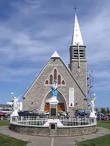 | |||
| 131 George Street | 131 George Street, Dalhousie, NB | 48°03′52″N 66°22′49″W | 7129 | | |||
| Glenwood Provincial Park | Route 17, Eldon, NB | 47°51′06″N 67°00′21″W | 6405 | | |||
| La Grande École | 182 Canada Street, Saint-Quentin, NB | 47°30′36″N 67°23′30″W | 2965 | | |||
| Hamilton Monument | Corner of Hall and Adelaide Streets, Dalhousie, NB | 48°03′55″N 66°22′34″W | 7086 | | |||
| Inch Arran Park | Inch Arran Avenue, Dalhousie, NB | 48°03′36″N 66°21′10″W | 7124 | | |||
| Louis A. Lebel House | 213 Canada Street, Saint-Quentin, NB | 47°30′44″N 67°23′33″W | 6662 | | |||
| Lynch-Chouinard House | 231 Mgr. Martin Road East, Saint-Quentin, NB | 47°30′47″N 67°22′54″W | 3437 | | |||
| Patrick Jean Store | 162 Canada Street, Saint-Quentin, NB | 47°30′32″N 67°23′33″W | 6664 | | |||
| MacLean Residence | 442 Adelaide Street, Dalhousie, NB | 48°03′55″N 66°22′49″W | 7733 | | |||
| Martel Dairy Farm | 282 Canada Street, Saint-Quentin, NB | 47°31′03″N 67°23′28″W | 2960 | | |||
| Miller Farm | 456 Sunset Drive, Dalhousie, NB | 48°02′28″N 66°24′48″W | 7233 | | |||
| Old Royal Bank Building | 420 William Street, Dalhousie, NB | 48°03′59″N 66°22′31″W | 18122 | | |||
| Railway Station Warehouses | Near the reconstructed railway station on Canada Street, Saint-Quentin, NB | 47°30′28″N 67°23′28″W | 3133 | | |||
| J. B. Rioux Building | 234 Canada Street, Saint-Quentin, NB | 47°30′50″N 67°23′31″W | 3131 | | |||
| Riverview Cemetery | south of 107 Renfrew Street, Dalhousie, NB | 48°03′55″N 66°22′07″W | 7085 | | |||
| Rotary Memorial Park | Bounded by the Courthouse and Jail, and William, Court and Hall Streets, Dalhousie, NB | 48°03′58″N 66°22′33″W | 7232 | | |||
| Léopold Roy House | 212 Canada St., Saint-Quentin, NB | 47°30′44″N 67°23′30″W | 5335 | | |||
| Saint-Jean-Baptiste Church | 336 Church Lane, Dalhousie, NB | 48°03′47″N 66°22′01″W | 7234 | | |||
| St. John's United Church | 135 Brunswick Street, Dalhousie, NB | 48°03′53″N 66°22′18″W | 7130 | | |||
| St. Mary's Anglican Church | 115 Hall Street, Dalhousie, NB | 48°03′55″N 66°22′32″W | 7084 | | |||
| Bert Somers House | 11 Champlain Street, Saint-Quentin, NB | 47°30′32″N 67°23′26″W | 6653 | | |||
| Steeple Rooster | 188 Canada Street, Saint-Quentin, NB | 47°30′39″N 67°23′30″W | 6648 | More images | |||
| Reid Stewart Home | 104 Farm Lane, Dalhousie, NB | 48°03′29″N 66°21′33″W | 7256 | | |||
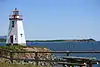
| Inch Arran Point Front Range Lighthouse | Inch Arran Point, Dalhousie, NB | 48°03′39″N 66°21′06″W | 9684 21094 |
 More images | |||
| Très Saint-Sacrement de Saint-Quentin Parish Rectory | 188 rue Canada, Saint-Quentin, NB | 47°30′38″N 67°23′30″W | 6665 | 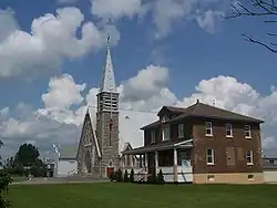 More images | |||
| Wolastoq National Historic Site of Canada | Entire watershed of Saint John River, central and western New Brunswick, parts of southeastern Quebec, NB | 47°25′38″N 66°54′05″W | 18954 | 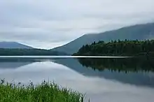 More images |
See also
| Wikimedia Commons has media related to Cultural heritage monuments in New Brunswick. |
This article is issued from Wikipedia. The text is licensed under Creative Commons - Attribution - Sharealike. Additional terms may apply for the media files.