List of islands in Shark Bay

This is a list of the islands in the Shark Bay area of the Gascoyne Region of Western Australia, (between 24°30′0″ and 26°30′0″ S, and 112°0′0″ and 114°30′0″ E).

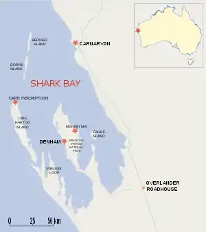
There are approximately 30 small islands in Shark Bay; all are within the World Heritage Reserve.[1]

The largest is Dirk Hartog Island.

IslandArea
(ha)
LocationVicinity
Baudin Island2026°30′54″S 113°38′55″EHenri Freycinet Harbour
Bernier Island4,00024°50′57″S 113°08′14″EBernier Island
Charles Island / Charlie Island 126°22′03″S 113°34′07″EHenri Freycinet Harbour
Dirk Hartog Island63,00025°50′36″S 113°03′18″EDirk Hartog Island
Dorre Island4,90025°03′26″S 113°06′04″EBernier Island
Double Island126°24′57″S 113°36′59″EHenri Freycinet Harbour
Egg Island125°54′34″S 113°09′20″EDirk Hartog Island
Faure Island5,20025°51′22″S 113°53′35″EFaure Island
Freycinet Island326°24′26″S 113°37′00″EHenri Freycinet Harbour
Friday Island126°06′09″S 113°24′09″EFreycinet Reach
Koks Island424°45′02″S 113°09′33″EBernier Island
Mary Anne Island126°29′06″S 113°40′59″EHenri Freycinet Harbour
North Guano Island626°31′59″S 113°41′25″EHenri Freycinet Harbour
Pelican Island825°51′12″S 114°00′48″EFaure Is
Salutation Island17026°32′22″S 113°45′56″EHenri Freycinet Harbour
South Guano Island226°32′45″S 113°41′26″EHenri Freycinet Harbour
Three Bays Island526°33′15″S 113°38′46″EHenri Freycinet Harbour
White Island126°26′38″S 113°45′41″EHenri Freycinet Harbour
Wilds Island126°27′06″S 113°36′54″EHenri Freycinet Harbour
Ant Island26°09′47″S 113°26′32″E
Babbage Island8424°52′39″S 113°37′57″ECarnarvon
Boora Island24°45′25″S 114°11′45″E
Eagle Island126°05′40″S 113°34′30″EFreycinet Reach
Hutchison Islands126°06′47″S 114°14′05″EFaure Island
Kangaroo Island126°19′09″S 113°29′58″EHenri Freycinet Harbour
Lefebre Island626°13′50″S 113°30′25″EHenri Freycinet Harbour
Meade Island126°00′05″S 113°11′57″EDirk Hartog Island
North Kangaroo Island126°17′57″S 113°30′11″EHenri Freycinet Harbour
Parrot Island26°24′45″S 113°30′09″E
Slope Island526°05′27″S 113°24′45″EFreycinet Reach
Smith Islands126°35′20″S 113°43′35″EHenri Freycinet Harbour
Sunday Island26°07′32″S 113°14′06″E
Unknown Island26°23′16″S 113°22′16″E
Whitlock Island24°53′14″S 113°38′44″E
Whitmore Island24°52′00″S 113°37′20″E
Wilson Island26°09′55″S 113°39′33″E

See also

References

  1. "Shark Bay World Heritage Property, Environmental values, Cultural uses and potential Petroleum Industry impacts" (PDF). Department of Environmental Protection. July 2001. Archived from the original (PDF) on 12 November 2009. Retrieved 23 August 2010.
This article is issued from Wikipedia. The text is licensed under Creative Commons - Attribution - Sharealike. Additional terms may apply for the media files.