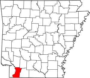
List of lakes of Lafayette County, Arkansas
Lakes
- 1927 Cut-off Lake, 33°27′39″N 093°42′38″W, el. 233 feet (71 m) [1]
- Battle Lake, 33°18′28″N 093°39′43″W, el. 217 feet (66 m) [2]
- Blue Hole, 33°05′43″N 093°50′42″W, el. 200 feet (61 m) [3]
- Cargill Pond, 33°20′21″N 093°37′38″W, el. 249 feet (76 m) [4]
- Copeland Lake, 33°14′26″N 093°42′09″W, el. 203 feet (62 m) [5]
- Duck Lake, 33°20′41″N 093°39′10″W, el. 217 feet (66 m) [6]
- Grassy Lake, 33°26′35″N 093°41′33″W, el. 230 feet (70 m) [7]
- Mays Lake, 33°24′54″N 093°41′59″W, el. 226 feet (69 m) [8]
- Mays Lake, 33°16′49″N 093°39′39″W, el. 223 feet (68 m) [9]
- Spirit Lake, 33°21′14″N 093°39′59″W, el. 220 feet (67 m) [10]
- Swan Lake, 33°15′05″N 093°40′32″W, el. 213 feet (65 m) [11]
Reservoirs
- Barmes Pond, 33°22′40″N 093°35′02″W, el. 305 feet (93 m) [12]
- Buehler Herndon Lake Number Two, 33°24′24″N 093°35′44″W, el. 305 feet (93 m) [13]
- Buehler Herndon Number One Reservoir, 33°23′48″N 093°35′49″W, el. 289 feet (88 m) [14]
- Enyart Lake, 33°02′33″N 093°44′00″W, el. 197 feet (60 m) [15]
- Lake Erling, 33°05′38″N 093°32′35″W, el. 217 feet (66 m) [16]
- Lake June, 33°21′18″N 093°29′31″W, el. 259 feet (79 m) [17]
- Lower Lake Jew Jon, 33°09′11″N 093°41′51″W, el. 236 feet (72 m) [18]
- Meriwether Pond, 33°23′34″N 093°33′56″W, el. 295 feet (90 m) [19]
- Moore Lake, 33°22′54″N 093°38′31″W, el. 226 feet (69 m) [20]
- New Meriwether Pond, 33°23′56″N 093°35′46″W, el. 285 feet (87 m) [21]
- Strange Lake, 33°20′00″N 093°29′49″W, el. 299 feet (91 m) [22]
- Upper Jew-Jon Lake, 33°09′10″N 093°42′16″W, el. 256 feet (78 m) [23]
See also
- List of lakes in Arkansas
Notes
- "1927 Cut-off Lake". Geographic Names Information System. United States Geological Survey.
- "Battle Lake". Geographic Names Information System. United States Geological Survey.
- "Blue Hole". Geographic Names Information System. United States Geological Survey.
- "Cargill Pond". Geographic Names Information System. United States Geological Survey.
- "Copeland Lake". Geographic Names Information System. United States Geological Survey.
- "Duck Lake". Geographic Names Information System. United States Geological Survey.
- "Grassy Lake". Geographic Names Information System. United States Geological Survey.
- "Mays Lake". Geographic Names Information System. United States Geological Survey.
- "Mays Lake". Geographic Names Information System. United States Geological Survey.
- "Spirit Lake". Geographic Names Information System. United States Geological Survey.
- "Swan Lake". Geographic Names Information System. United States Geological Survey.
- "Barmes Pond". Geographic Names Information System. United States Geological Survey.
- "Buehler Herndon Lake Number Two". Geographic Names Information System. United States Geological Survey.
- "Buehler Herndon Number One Reservoir". Geographic Names Information System. United States Geological Survey.
- "Enyart Lake". Geographic Names Information System. United States Geological Survey.
- "Lake Erling". Geographic Names Information System. United States Geological Survey.
- "Lake June". Geographic Names Information System. United States Geological Survey.
- "Lower Lake Jew Jon". Geographic Names Information System. United States Geological Survey.
- "Meriwether Pond". Geographic Names Information System. United States Geological Survey.
- "Moore Lake". Geographic Names Information System. United States Geological Survey.
- "New Meriwether Pond". Geographic Names Information System. United States Geological Survey.
- "Strange Lake". Geographic Names Information System. United States Geological Survey.
- "Upper Jew-Jon Lake". Geographic Names Information System. United States Geological Survey.
This article is issued from Wikipedia. The text is licensed under Creative Commons - Attribution - Sharealike. Additional terms may apply for the media files.
