Lewisville, Arkansas
Lewisville is a city in Lafayette County, Arkansas, United States. The population was 1,280 at the 2010 census.[3] It is the county seat of Lafayette County.[4]
Lewisville, Arkansas | |
|---|---|
City | |
 Lafayette County Courthouse | |
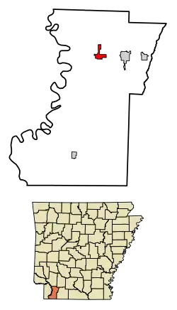 Location in Lafayette County, Arkansas | |
| Coordinates: 33°21′38″N 93°34′46″W | |
| Country | United States |
| State | Arkansas |
| County | Lafayette |
| Area | |
| • Total | 2.18 sq mi (5.65 km2) |
| • Land | 2.15 sq mi (5.56 km2) |
| • Water | 0.03 sq mi (0.08 km2) |
| Elevation | 292 ft (89 m) |
| Population (2010) | |
| • Total | 1,280 |
| • Estimate (2019)[2] | 1,114 |
| • Density | 518.62/sq mi (200.25/km2) |
| Time zone | UTC−06:00 (Central (CST)) |
| • Summer (DST) | UTC−05:00 (CDT) |
| ZIP Code | 71845 |
| Area code(s) | 870 |
| FIPS code | 05-39640 |
| GNIS feature ID | 0077484 |
Geography
Lewisville is located in northern Lafayette County at 33°21′38″N 93°34′46″W (33.360636, -93.579317).[5] U.S. Route 82 passes through the south side of the city, leading east 23 miles (37 km) to Magnolia and west 30 miles (48 km) to Texarkana. Arkansas Highway 29 passes through the center of Lewisville, leading north 23 miles (37 km) to Hope and south 19 miles (31 km) to Bradley.
According to the United States Census Bureau, Lewisville has a total area of 2.2 square miles (5.7 km2), of which 0.03 square miles (0.09 km2), or 1.58%, are water.[3]
Demographics
| Historical population | |||
|---|---|---|---|
| Census | Pop. | %± | |
| 1880 | 301 | — | |
| 1890 | 500 | 66.1% | |
| 1900 | 548 | 9.6% | |
| 1910 | 975 | 77.9% | |
| 1920 | 1,067 | 9.4% | |
| 1930 | 1,061 | −0.6% | |
| 1940 | 1,314 | 23.8% | |
| 1950 | 1,237 | −5.9% | |
| 1960 | 1,373 | 11.0% | |
| 1970 | 1,653 | 20.4% | |
| 1980 | 1,476 | −10.7% | |
| 1990 | 1,424 | −3.5% | |
| 2000 | 1,285 | −9.8% | |
| 2010 | 1,280 | −0.4% | |
| 2019 (est.) | 1,114 | [2] | −13.0% |
| U.S. Decennial Census[6] | |||
As of the census[7] of 2000, there were 1,285 people, 518 households, and 349 families residing in the town. The population density was 583.7 people per square mile (225.5/km2). There were 577 housing units at an average density of 262.1/sq mi (101.3/km2). The racial makeup of the city was 49.34% White, 49.34% Black or African American, 0.16% Native American, 0.70% from other races, and 0.47% from two or more races. 2.10% of the population were Hispanic or Latino of any race.
There were 518 households, out of which 28.8% had children under the age of 18 living with them, 46.7% were married couples living together, 16.2% had a female householder with no husband present, and 32.6% were non-families. 30.1% of all households were made up of individuals, and 15.3% had someone living alone who was 65 years of age or older. The average household size was 2.47 and the average family size was 3.04.
In the city, the population was spread out, with 25.8% under the age of 18, 7.9% from 18 to 24, 25.7% from 25 to 44, 22.3% from 45 to 64, and 18.3% who were 65 years of age or older. The median age was 39 years. For every 100 females, there were 86.5 males. For every 100 females age 18 and over, there were 80.5 males.
The median income for a household in the town was $26,719, and the median income for a family was $34,712. Males had a median income of $24,408 versus $16,850 for females. The per capita income for the city was $13,733. About 17.2% of families and 21.3% of the population were below the poverty line, including 27.3% of those under age 18 and 16.1% of those age 65 or over.
Education
Public education for elementary and secondary students is provided by the Lafayette County School District. On July 1, 2003, the Lewisville district consolidated with the Stamps School District to form the Lafayette County School District.[8]
Infrastructure
Highways
 U.S. Highway 82
 Arkansas Highway 29
 Arkansas Highway 313
Gallery
 Burges BBQ and Ice Cream stand has existed in Lewisville since the early 1960s.
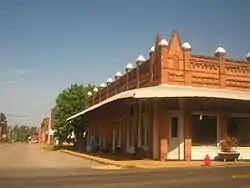 An abandoned historic building in downtown Lewisville
Notable people
- W. W. Carloss, member of the Louisiana House of Representatives, 1874-1878; fought in Siege of Port Hudson, 1863; lived in Lafayette County after 1878
- Lewis B. Fort, one of the first settlers in Lafayette County and the individual whose given name was used in naming the town of Lewisville
- Charles McClendon, former LSU football coach
References
- "2019 U.S. Gazetteer Files". United States Census Bureau. Retrieved June 30, 2020.
- "Population and Housing Unit Estimates". United States Census Bureau. May 24, 2020. Retrieved May 27, 2020.
- "Geographic Identifiers: 2010 Census Summary File 1 (G001), Lewisville city, Arkansas". American FactFinder. U.S. Census Bureau. Archived from the original on February 13, 2020. Retrieved August 20, 2019.
- "Find a County". National Association of Counties. Archived from the original on May 31, 2011. Retrieved 2011-06-07.
- "US Gazetteer files: 2010, 2000, and 1990". United States Census Bureau. 2011-02-12. Retrieved 2011-04-23.
- "Census of Population and Housing". Census.gov. Retrieved June 4, 2015.
- "U.S. Census website". United States Census Bureau. Retrieved 2008-01-31.
- "ConsolidationAnnex_from_1983.xls." Arkansas Department of Education. Retrieved on October 13, 2017.
Municipalities and communities of Lafayette County, Arkansas, United States | ||
|---|---|---|
| Cities | 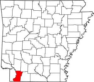 Map of Arkansas highlighting Lafayette County | |
| Town | ||
| Unincorporated communities | ||
| ||