List of listed buildings in Maybole, South Ayrshire
List
| Name | Location | Date Listed | Grid Ref. [note 1] | Geo-coordinates | Notes | LB Number [note 2] | Image |
|---|---|---|---|---|---|---|---|
| Culzean Road Whitefaulds | 55°21′14″N 4°41′25″W | Category B | 37693 |  | |||
| Dailly Road Church Of Our Lady & St Cuthbert's School And Presbytery | 55°20′56″N 4°41′01″W | Category B | 37694 | | |||
| 27-31 (Odd) High Street | 55°21′14″N 4°40′53″W | Category B | 37701 | | |||
| 55-59 (Odd) High Street | 55°21′14″N 4°40′55″W | Category C(S) | 37706 | | |||
| High Street, Maybole Castle, Garden Walls And Gatepiers | 55°21′17″N 4°40′52″W | Category A | 37709 | 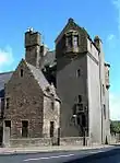 | |||
| 8, 10 Kirkland Street | 55°21′23″N 4°40′38″W | Category C(S) | 37715 | | |||
| Obelisk, Kildoon | 55°19′51″N 4°40′59″W | Category B | 14277 | | |||
| Dunure Castle | 55°24′18″N 4°45′43″W | Category A | 14293 | 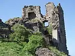 | |||
| 2 Greenside | 55°21′14″N 4°41′04″W | Category C(S) | 37695 | | |||
| 18 Greenside | 55°21′15″N 4°41′09″W | Category B | 37697 | | |||
| 33-35 (Odd) High Street | 55°21′14″N 4°40′54″W | Category C(S) | 37702 | | |||
| 43-47 (Odd) High Street | 55°21′14″N 4°40′55″W | Category C(S) | 37704 | | |||
| 1, 3, 5 Kirkland Street | 55°21′23″N 4°40′36″W | Category C(S) | 37712 | | |||
| Dunure Harbour | 55°24′25″N 4°45′29″W | Category B | 19683 | 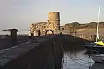 | |||
| High Greenan House | 55°25′52″N 4°40′14″W | Category B | 18846 | | |||
| Enoch Lodge | 55°21′32″N 4°43′17″W | Category B | 14289 | | |||
| East Enoch | 55°21′31″N 4°42′05″W | Category B | 14291 | | |||
| Dunure Mill At Dunure Mains | 55°23′46″N 4°45′39″W | Category B | 14292 | | |||
| Monkwood | 55°23′58″N 4°37′25″W | Category B | 14301 | | |||
| 3 Cargill Road Fair Knowe And Gatepiers | 55°21′18″N 4°41′12″W | Category C(S) | 37678 | | |||
| 14 Cassillis Road | 55°21′22″N 4°40′43″W | Category C(S) | 37681 | | |||
| 3 High Street, Post Office | 55°21′17″N 4°40′50″W | Category C(S) | 37699 | | |||
| 25 High Street | 55°21′15″N 4°40′53″W | Category C(S) | 37700 | | |||
| 1-7 Whitehall (Odd Nos) | 55°21′11″N 4°41′00″W | Category B | 37721 | | |||
| 4 Whitehall | 55°21′11″N 4°41′02″W | Category B | 37724 | | |||
| Lodge,Stables And Gatepiers,High Greenan House | 55°25′55″N 4°40′11″W | Category B | 18847 | | |||
| Nether Auchindrane House | 55°24′55″N 4°37′37″W | Category C(S) | 14278 | | |||
| Greenan Castle | 55°26′19″N 4°40′13″W | Category B | 14298 | | |||
| Newark Castle | 55°25′17″N 4°39′08″W | Category A | 14300 | | |||
| Kilhenzie Castle | 55°20′20″N 4°40′07″W | Category B | 14305 | | |||
| Ashgrove Ashgrove House | 55°21′26″N 4°41′04″W | Category B | 37677 | | |||
| 16-18 (Even) Cassillis Road | 55°21′21″N 4°40′44″W | Category B | 37682 | | |||
| 33 Castle Street | 55°21′18″N 4°40′58″W | Category C(S) | 37687 | | |||
| Collegiate Church | 55°21′12″N 4°40′49″W | Category A | 37688 | 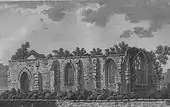 | |||
| 19 Greenside | 55°21′16″N 4°41′09″W | Category B | 37698 | | |||
| 37-41 (Odd) High Street | 55°21′14″N 4°40′54″W | Category C(S) | 37703 | | |||
| High Street, The Tolbooth | 55°21′12″N 4°40′59″W | Category B | 37708 | | |||
| 4 Kirkland Street | 55°21′23″N 4°40′38″W | Category C(S) | 37713 | | |||
| Old Cemetery Gate And Walls | 55°21′14″N 4°40′47″W | Category C(S) | 37717 | | |||
| St John's Cottage | 55°21′23″N 4°40′13″W | Category A | 37718 | | |||
| Welltrees Street Welltrees The Gluepot Bar | 55°20′50″N 4°41′01″W | Category C(S) | 37720 | | |||
| 2 Whitehall The Royal Bank Of Scotland | 55°21′12″N 4°41′01″W | Category B | 37723 | | |||
| Dunduff Farm | 55°24′27″N 4°44′33″W | Category B | 19684 | | |||
| Inn And Adjoining Smithy Culroy | 55°23′43″N 4°39′33″W | Category B | 14302 | | |||
| 96 Ladywell Road (Formerly Weavers Vennel) | 55°21′02″N 4°41′09″W | Category C(S) | 37716 | | |||
| 6, 8 Whitehall | 55°21′11″N 4°41′03″W | Category C(S) | 37725 | | |||
| Nether Culzean | 55°22′07″N 4°39′21″W | Category B | 19685 | | |||
| Sauchrie | 55°23′46″N 4°40′57″W | Category B | 14290 | | |||
| Kirkbride | 55°24′23″N 4°44′45″W | Category B | 14297 | | |||
| Grange | 55°23′33″N 4°39′22″W | Category B | 14304 | | |||
| Doonside Estate, Doonside Dovecot | 55°25′24″N 4°38′02″W | Category B | 47356 | | |||
| 10 Greenside | 55°21′14″N 4°41′06″W | Category C(S) | 37696 | | |||
| 67 High Street Bank Of Scotland | 55°21′13″N 4°40′56″W | Category B | 37707 | | |||
| 6 Kirkland Street | 55°21′23″N 4°40′38″W | Category C(S) | 37714 | | |||
| 2 School Vennel And 82 High Street | 55°21′13″N 4°40′58″W | Category C(S) | 37719 | | |||
| Dovecote, Dunure | 55°24′19″N 4°45′40″W | Category A | 14294 | 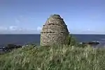 | |||
| 31 Whitehall | 55°21′08″N 4°41′06″W | Category C(S) | 49585 | | |||
| 23 Cassillis Road | 55°21′20″N 4°40′44″W | Category B | 37679 | | |||
| 25-27 (Odd) Cassillis Road | 55°21′20″N 4°40′45″W | Category B | 37680 | | |||
| 24 Cassillis Road | 55°21′21″N 4°40′46″W | Category C(S) | 37684 | | |||
| Cassillis Road Old Parish Church | 55°21′23″N 4°40′41″W | Category B | 37686 | | |||
| Coral Hill West Parish Church | 55°21′02″N 4°41′21″W | Category C(S) | 37689 | | |||
| 49-53 (Odd) High Street | 55°21′14″N 4°40′55″W | Category C(S) | 37705 | | |||
| 88-90 (Even) High Street | 55°21′13″N 4°40′59″W | Category C(S) | 37711 | | |||
| 9 Whitehall | 55°21′11″N 4°41′01″W | Category B | 37722 | | |||
| Dunure House By Harbour | 55°24′30″N 4°45′24″W | Category B | 14295 | | |||
| Dunduff Castle | 55°24′39″N 4°43′52″W | Category B | 14296 | | |||
| Otterden House | 55°23′44″N 4°40′20″W | Category B | 14303 | | |||
| Brae Of Auchendrane With Service Court, Terraces, Gates And Gatepiers | 55°24′13″N 4°38′10″W | Category B | 47336 | | |||
| 1 High Street, Carnegie Free Public Library | 55°21′17″N 4°40′49″W | Category C(S) | 49582 | | |||
| 22 Cassillis Road | 55°21′21″N 4°40′45″W | Category C(S) | 37683 | | |||
| 26 Cassillis Road | 55°21′21″N 4°40′45″W | Category C(S) | 37685 | | |||
| Coral Hill West Parish Manse | 55°21′00″N 4°41′16″W | Category C(S) | 37690 | | |||
| Culzean Road Barns House | 55°21′20″N 4°40′54″W | Category B | 37691 | | |||
| Culzean Road Kincraig | 55°21′17″N 4°41′15″W | Category B | 37692 | | |||
| 32-36 High Street | 55°21′16″N 4°40′54″W | Category C(S) | 37710 | | |||
| West Enoch Farm | 55°21′31″N 4°42′55″W | Category B | 19861 | |
Key
The scheme for classifying buildings in Scotland is:
- Category A: "buildings of national or international importance, either architectural or historic; or fine, little-altered examples of some particular period, style or building type."[1]
- Category B: "buildings of regional or more than local importance; or major examples of some particular period, style or building type, which may have been altered."[1]
- Category C: "buildings of local importance; lesser examples of any period, style, or building type, as originally constructed or moderately altered; and simple traditional buildings which group well with other listed buildings."[1]
In March 2016 there were 47,288 listed buildings in Scotland. Of these, 8% were Category A, and 50% were Category B, with the remaining 42% being Category C.[2]
Notes
- Sometimes known as OSGB36, the grid reference (where provided) is based on the British national grid reference system used by the Ordnance Survey.
• "Guide to National Grid". Ordnance Survey. Retrieved 12 December 2007.
• "Get-a-map". Ordnance Survey. Retrieved 17 December 2007. - Historic Environment Scotland assign a unique alphanumeric identifier to each designated site in Scotland, for listed buildings this always begins with "LB", for example "LB12345".
References
- All entries, addresses and coordinates are based on data from Historic Scotland. This data falls under the Open Government Licence
- "What is Listing?". Historic Environment Scotland. Retrieved 29 May 2018.
- Scotland's Historic Environment Audit 2016 (PDF). Historic Environment Scotland and the Built Environment Forum Scotland. pp. 15–16. Retrieved 29 May 2018.
This article is issued from Wikipedia. The text is licensed under Creative Commons - Attribution - Sharealike. Additional terms may apply for the media files.