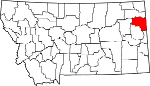
List of mountains in Richland County, Montana
There are at least 11 named mountains in Richland County, Montana.
- Antelope Butte, 47°59′30″N 104°14′08″W, el. 2,405 feet (733 m)[1]
- Bell Hill, 47°38′22″N 104°14′03″W, el. 2,018 feet (615 m)[2]
- Blue Hill, 47°57′10″N 104°25′12″W, el. 2,628 feet (801 m)[3]
- Bull Butte, 47°28′37″N 104°06′04″W, el. 2,480 feet (760 m)[4]
- Flag Butte, 47°48′33″N 104°46′07″W, el. 2,736 feet (834 m)[5]
- Haystack Butte, 48°02′25″N 104°56′57″W, el. 2,408 feet (734 m)[6]
- Lindberg Hill, 47°26′32″N 104°09′22″W, el. 2,543 feet (775 m)[7]
- Lone Butte, 47°53′00″N 104°28′05″W, el. 2,572 feet (784 m)[8]
- The Pyramid, 47°31′21″N 104°13′48″W, el. 2,142 feet (653 m)[9]
- Three Buttes, 48°01′53″N 104°25′32″W, el. 2,503 feet (763 m)[10]
- Three Buttes, 47°43′57″N 104°33′35″W, el. 2,723 feet (830 m)[11]
Notes
- "Antelope Butte". Geographic Names Information System. United States Geological Survey.
- "Bell Hill". Geographic Names Information System. United States Geological Survey.
- "Blue Hill". Geographic Names Information System. United States Geological Survey.
- "Bull Butte". Geographic Names Information System. United States Geological Survey.
- "Flag Butte". Geographic Names Information System. United States Geological Survey.
- "Haystack Butte". Geographic Names Information System. United States Geological Survey.
- "Lindberg Hill". Geographic Names Information System. United States Geological Survey.
- "Lone Butte". Geographic Names Information System. United States Geological Survey.
- "The Pyramid". Geographic Names Information System. United States Geological Survey.
- "Three Buttes". Geographic Names Information System. United States Geological Survey.
- "Three Buttes". Geographic Names Information System. United States Geological Survey.
This article is issued from Wikipedia. The text is licensed under Creative Commons - Attribution - Sharealike. Additional terms may apply for the media files.
