List of places on the Victorian Heritage Register in the City of Latrobe
This is a list of places on the Victorian Heritage Register in the City of Latrobe in Victoria, Australia. The Victorian Heritage Register is maintained by the Heritage Council of Victoria.
The Victorian Heritage Register, as of 2020, lists the following nine state-registered places within the City of Latrobe:[1]
| Place name | Place # | Location | Suburb or Town | Co-ordinates | Built | Stateregistered | Photo |
|---|---|---|---|---|---|---|---|
| Azarole Hawthorn tree | H2135 | Victory Park, Mill St | Traralgon | 38.195880°S 146.541690°E | unknown | 12 February 2009 | |
| Loren | H1283 | Old Gippstown, 211 Lloyd St | Moe | 38.185340°S 146.236290°E | 1854 | 9 January 1997 | 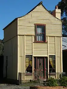 |
| Mechanics Institute and Free Library | H0544 | 12-16 King St | Toongabbie | 38.059000°S 146.622350°E | 1883 | 14 December 1983 | |
| Morwell Power Station and Briquette Factory | H2377 | 412 Commercial Rd | Morwell | 38.250220°S 146.416760°E | 1949 | 1 March 2018 | |
| No. 21 Dredger | H2130 | Ridge Rd | Morwell | 38.243000°S 146.412730°E | 1950-55 | 12 August 2010 | |
| Staplegrove Meat Works | H1666 | 50 Berkleys Rd | Flynn | 38.173300°S 146.700350°E | 1870s | 13 September 2007 | |
| Traralgon Engine Shed and Turntable | H1979 | Queens Pde | Traralgon | 38.198630°S 146.540270°E | 1902 | 10 April 2003 | |
| Traralgon Post Office and Court House | H1488 | 161-165 Franklin St | Traralgon | 38.195130°S 146.537750°E | 1886 | 20 August 1982 |  |
| Yallourn Power Station Administrative Building | H1054 | Yallourn Dve | Yallourn | 38.174660°S 146.348460°E | 1922-23 | 15 March 2001 |
References
- "Latrobe City". Victorian Heritage Database. Heritage Council of Victoria. Retrieved 10 April 2020.
This article is issued from Wikipedia. The text is licensed under Creative Commons - Attribution - Sharealike. Additional terms may apply for the media files.