List of rock formations of New Zealand
This is a list of rock formations in New Zealand based on their aesthetic and cultural importance. New Zealand's geomorphology is formed through an interaction between uplift, erosion and the underlying rock type. Most of the notable examples listed here are formed by selective erosion, for example waves and rivers can more easily erode sandstone than basalt and can also exploit joints or faults in the rock-mass.[1] Some rocks like limestone (Waitomo Caves) and marble (Takaka Hill) can also be dissolved in water which forms a distinctive karst geomorpholohy. Notable rock formations are also formed through constructive processes such as geothermal and volcanic deposits, and sedimentary deposition.
North Island formations
| Photo | Formation | Region | Type | Summary | Location |
|---|---|---|---|---|---|
 |
Cape Kidnappers | Hawke's Bay | Wave erosion, sea stack | 39.647473°S 177.086699°E | |
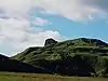 |
Castle Craig Rock | Waikato | Terrestrial erosion | 38°15′35″S 174°49′15″E | |
.JPG.webp) |
Castlepoint | Wellington, Wairarapa | Wave erosion | 40°53′55″S 176°13′14″E | |
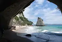 |
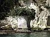
Cathedral Cove | Waikato, Coromandel Peninsula | Wave erosion, cave, sea stack | 36°49′42″S 175°47′24″E | |
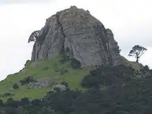 |
The Dome of Saint Paul | Northland, Whangaroa | Terrestrial erosion, igneous rock | 35.050731°S 173.749623°E | |
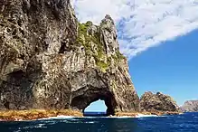 |
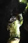
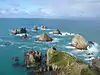
Hole in the Rock | Northland, Piercy Island | Wave erosion, Natural arch | Limestone island with a natural arch. Significant tourist attraction. | 35.165437°S 174.339061°E |
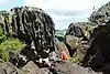 |
Horeke basalts, Wairere Boulders | Northland | Terrestrial erosion, igneous rock | Lava flow broken up as lower strata removed by erosion. Notable corrugation on basalt boulders.[2] | 35.374687°S 173.596301°E |
 |
Kupe's Sail | Wellington, Wairarapa, Palliser Bay | A dipping bed of slightly more resistant rock protruding above weaker rock. | 41.60448°N 175.26616°E | |
 |
Koutu Boulders | Northland | Wave erosion | 35.458139°S 173.414767°E | |
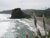 |
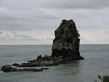
Lion Rock | Auckland, Piha | Wave erosion, sea stack | Prominent islet with shear cliffs of volcanic conglomerate | 36.953685°S 174.465880°E |
 |
Mangapohue Natural Bridge | Waikato | Terrestrial erosion, karst | 38.261043°S 174.899301°E | |
 |
Natural Vase | Waikato, Coromandel Peninsula | Wave erosion | ||
 |
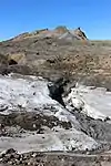
Orakei Korako (including Golden Fleece Terrace and Rainbow Terrace) | Bay of Plenty | Geothermal | Geothermal terraces formed by minerals precipitating as the water cools. | 38°28′25″S 176°08′55″E |
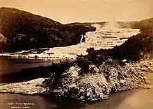 |
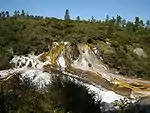
Pink and White Terraces | Bay of Plenty, Mount Tarawera | Geothermal | Significant geothermal terraces formed by minerals precipitating as the water cools.These terraces were thought destroyed by the 1886 eruption of Mount Tarawera, however they may have just been buried.[3] | 38°15′40″S 176°25′50″E |
.jpg.webp) |
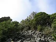
The Pinnacles | Waikato, Coromandel Peninsula | Terrestrial erosion, volcanic rock | Andesite lava spires preserved when the weaker neighboring pyroclastic rocks were eroded.[4] | 37.043223°S 175.726249°E |
 |
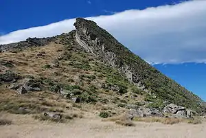
Pinnacle Ridge and Cathedral Rocks | Wanganui-Manawatu, Mount Ruapehu | Terrestrial erosion, volcanic rock | Rock spires of andesite near summit of Mount Ruapehu. | 39°14′30″S 175°34′00″E |
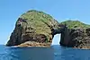 |
Poor Knights Islands | Northland | Wave erosion, natural arch | 35°30′S 174°45′E | |
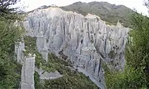 |
Putangirua Pinnacles | Wellington, Wairarapa | Terrestrial erosion, sedimentary rock | 41°27′05″S 175°13′20″E | |
| Te Kaukau Point | Wellington, Wairarapa | Wave erosion | 41°34′20″S 175°25′50″E | ||
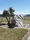
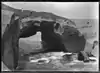
| Three Sisters and Elephant Rock[5] | Taranaki | Wave erosion, sea stacks and natural arch | Notable for their well documented partial destruction from wave erosion. | 38.819608°S 174.580815°E | |
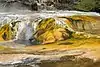 |
Waimangu Volcanic Rift Valley (including Cathedral Rocks and Warbrick Terrace) | Bay of Plenty | Geothermal | 38°17′10″S 176°23′15″E | |
 |
Waro Limestone Reserve | Northland, Hikurangi | Terrestrial erosion, sedimentary rock | 35°35′15″S 174°17′10″E | |
 |
Young Nick's Head | Gisborne | Wave erosion | 38°45′25″S 177°57′50″E | |
South Island formations
| Photo | Formation | Region | Type | Summary | Location |
|---|---|---|---|---|---|
 |
Blackhead | Otago, Dunedin | Wave erosion, volcanic rock and sea stacks | Rock spires with basaltic columnar jointing | 45°55′50″S 170°26′00″E |
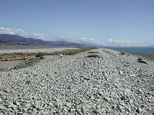 |
Boulder Bank | Nelson | Wave erosion and deposition | 41°14′S 173°18′E | |
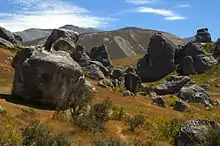 |
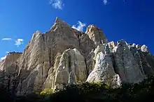
Castle Hill | Canterbury | Terrestrial erosion, sedimentary rock | 43°13′45″S 171°43′00″E | |
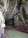 |
Cathedral Caves | Otago, The Catlins | Wave erosion, cave | 46°36′30″S 169°22′50″E | |
 |
Cook's Head Rock | Otago | Wave erosion | 46°12′05″S 170°04′50″E | |
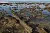 |
Curio Bay | Southland, The Catlins | Wave erosion | Petrified forest[2] | 46°39′45″S 169°05′55″E |
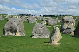 |
Elephant Rocks | Otago, Waitaki Valley | Terrestrial erosion, sedimentary rock | 44°53′35″S 170°39′20″E | |
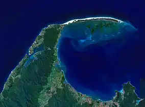 |
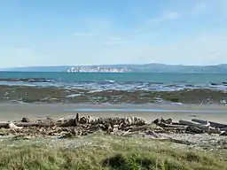
Farewell Spit | Tasman | Wave erosion and deposition | 40°31′S 172°52′E | |
 |
Huriawa Peninsula | Otago, Karitane | Wave erosion, natural arch and sea stacks | 45°38′30″S 170°40′00″E | |
 |
Kaitorete Spit | Canterbury | Wave erosion and deposition | 43°50′S 172°33′E | |
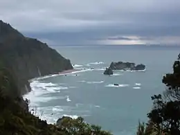 |
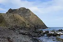
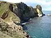
Knight's Point | West Coast | Wave erosion, sea stacks | Cliff and sea stacks formed by combination of uplift on the Alpine Fault and high erosion.[6] | 43°42′45″S 169°13′30″E |
 |
Lovers Leap and The Chasm[7] | Otago, Sandymount | Wave erosion, natural arch | 45.893014°S 170.678977°E | |
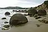 |
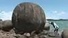
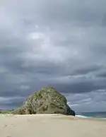
Moeraki Boulders | Otago | Wave erosion | Stong calcite concreations eroded out of a weak marine mudstone. Boulders also present in the cliff face and nearby streams.[2] | 45°20′55″S 170°49′40″E |
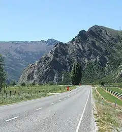 |
Nevis Bluff | Otago, Kawarau Valley | Seismic uplift, river erosion | Steep mica schist cliff face. | 45°02′15″S 168°59′50″E |
 |
Nugget Point | Otago, The Catlins | Wave erosion, sea stacks | Several sea stacks at the end of a prominent headland. The near vertical sandstone bedding creating steep planar cliffs. | 46°26′50″S 169°48′55″E |
| Obelisk (Kopuwai)[8] | Otago, Old Man Range | Freeze thaw weathering | 45°20′31″S 169°12′36″E | ||
 |
The Old Man of the Buller | West Coast, Buller River | 41°57′00″S 172°17′50″E | ||
 |
Omarama Clay Cliffs | Otago, Ahuriri Valley | Glacial erosion | 44°29′20″S 169°52′00″E | |
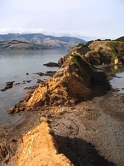 |
Ōnawe Peninsula | Canterbury, Banks Peninsula | Wave erosion | 43°46′30″S 172°55′30″E | |
 |
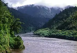
Oparara Basin Arches | West Coast | Terrestrial erosion, natural arch | Ground water erosion along the boundary of the basement granite and overlying limestone has formed caves and archers. | 41°08′45″S 172°11′15″E |
 |
The Organ Pipes | Otago, Dunedin | Terrestrial erosion, volcanic rock | Rock spire with basaltic columnar jointing | 45°48′30″S 170°34′00″E |
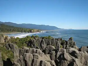 |
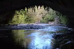
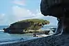
Pancake Rocks | West Coast, Punakaiki | Wave erosion, natural arch | A coastal karst geomorphology. The apparent bedding within the limestone may be due to pressure solution of calcite during burial.[2] | 42°06′50″S 171°19′35″E |
 |
Truman Track[9] | West Coast, Punakaiki | Wave erosion | Sea cliffs in sandstone and mudstone with a raised shore platform. | 42.091935°S 171.338737°E |
 |
Te Anau glacial erratic | Southland, Te Anau | Glacial deposition | A Geological Reserve. During a past glacial advance this boulder was carried c. 50 km from the Fiordland mountains.[10] | 45.524522°S 167.810208°E |
| The Pyramids | Otago, Dunedin | Wave erosion, seas stack | 45°49′25″S 170°43′15″E | ||
 |
Rapanui (Shag Rock) | Canterbury, Christchurch | Wave erosion, Sea Stack | Sea stack partially destroyed in the February 2011 Christchurch earthquake. | 43°33′50″S 172°45′00″E |
.jpg.webp) |
Split Apple Rock | Tasman | Wave erosion, igneous rock | A spheroidal granite block divided on a joint.[11] | 41°01′05″S 173°01′15″E |
 |
Tunnel Beach | Otago, Dunedin | Wave erosion, Natural arch | Sandstone sea cliffs and natural bridge, with man made tunnel. | 45°55′15″S 170°27′30″E |
.jpeg.webp) |
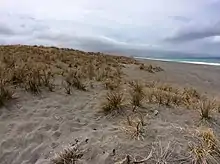
Wharariki Beach | Tasman | Wave erosion, natural arch | 40.502624°S 172.678686°E | |
Maps
Young Nick's Head
Cathedral Cove
Dome of Saint Paul
Waro Limestone Reserve
Putangirua Pinnacles
Cape Kidnappers
Pink and White Terraces
Lion Rock
Wairere Boulders
Hole in the Rock
Koutu Boulders
Kupe's Sail
Orakei Korako
Pinnacle Ridge
Castle Craig Rock & Mangapohue Natural Bridge
Te Kaukau Point
Waimangu Valley
The Pinnacles
Three Sisters and Elephant Rock
Castlepoint
Poor Knights Islands
Blackhead & Tunnel Beach
Kaitorete Spit
Old Man of the Buller
Huriawa Pen.
Split Apple Rock
Oparara River Arches
Rapanui Rock
Pancake Rocks & Trueman Track
Boulder Bank
Moeraki Boulders
Pyramids & Lovers Leap
Organ Pipes
Onawe Pen.
Nugget Pt.
Omarama Clay Cliffs
Cook's Head
Elephant Rocks
Curio Bay
Cathedral Caves
Castle Hill
Te Anau glacial erratic
Wharariki Beach
Farewell Spit
Knights Point
Obelisk
See also
References
- Cotton, Charles Andrew (1949). Geomorphology: an introduction to the study of landforms. Wiley.
- Thornton, Jocelyn (2009). The Field Guide to New Zealand Geology: An Introduction to Rocks, Minerals and Fossils. Penguin. ISBN 9780143202592.
- Bunn and Nolden, Rex and Sascha (December 2016). "Te Tarata and Te Otukapuarangi: Reverse engineering Hochstetter's Lake Rotomahana Survey to map the Pink and White Terrace locations". Journal of New Zealand Studies. NS23: 37–53.
- William), Hayward, Bruce W. (Bruce (1971). The geology and eruptive history of the Table Mountain region, Coromandel Peninsula (Thesis). ResearchSpace@Auckland.
- "Memory is all that's left of Elephant Rock, now trunk-less". Stuff. Retrieved 21 November 2018.
- Cooper, Alan F.; Kostro, Fabian (2006). "A tectonically uplifted marine shoreline deposit, Knights Point, Westland, New Zealand". New Zealand Journal of Geology and Geophysics. 49 (2): 203–216. doi:10.1080/00288306.2006.9515160. ISSN 0028-8306. S2CID 128895227.
- "Hidden Otago". hiddenotago.co.nz. Retrieved 21 November 2018.
- "History and culture". www.doc.govt.nz. Retrieved 12 December 2018.
- Wilson, Kerry-Jayne (2013). West Coast Walking: A Naturalist's Guide. Canterbury University Press. ISBN 9781927145425.
- Hayward, Bruce; Hayward, Bruce; Taonga, New Zealand Ministry for Culture and Heritage Te Manatu. "Glacial erratic at Te Anau". Retrieved 19 November 2018.
- "Split Apple Rock: Sitting pretty just off..." The Earth Story. Retrieved 21 November 2018.
This article is issued from Wikipedia. The text is licensed under Creative Commons - Attribution - Sharealike. Additional terms may apply for the media files.