Mount Cargill
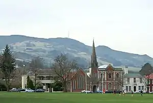
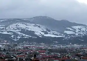
Mount Cargill, known in Māori as Kapukataumahaka,[1] is a volcanic outcrop which dominates the skyline of northern Dunedin, New Zealand.
The peak is named for Captain William Cargill, an early leader of the Province of Otago. Māori legend tells of the mountain showing the profile of a prominent warrior, and indeed from Dunedin Buttar's Peak and Mount Cargill between them do form the outline of a reclining figure, with the nearby Buttar's Peak being the head and Mount Cargill the body.
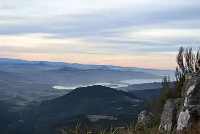
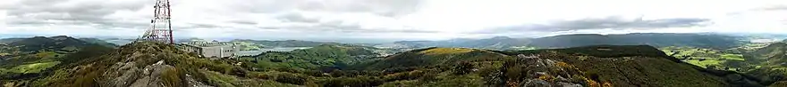
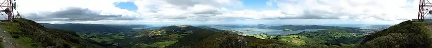
Panoramic views of Dunedin and its surrounding area are visible from the summit, making it a popular, if difficult to access, site. A single rough road ascends to the peak, and several popular walking tracks also ascend the slopes.
Mount Cargill is topped by a telecommunications station and mast, the Mount Cargill Transmitting Station. The mast is Dunedin's tallest man-made structure.
Geography
Mt. Cargill is situated some 15 kilometres (9 miles) north of the city centre, and dominates the city's northern skyline. It rises to a height of 676 metres (2,218 ft). To the north and east of Mount Cargill's peak are several smaller peaks including Mount Zion, Mount Holmes and (most notably) Buttar's Peak.
A rough road from the end of Pine Hill Road provides vehicular access to the summit, and several walking tracks also lead to the top, notably a 4-kilometre (2.5 mi) walk from Bethune's Gully in North East Valley at the northern end of Dunedin's urban area and a 6-kilometre (3.7 mi) walk through Graham's Bush, which starts in Sawyers Bay close to Port Chalmers. These tracks pass through regenerating native bush and volcanic outcrops before a sharp climb along the northern flank immediately below the summit.[2]
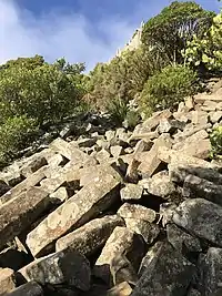
The tracks pass two significant points of interest. One of these is a prominent formation of columnar jointed basalt known as the Organ Pipes.[3] Similar outcrops are found elsewhere in the Dunedin area, at Blackhead near Waldronville and at Second Beach, Saint Clair. The second point of interest is the small temperate cloud forest which dominates the vegetation of the upper slopes. Though not a true cloud forest, in that it is not tropical, it bears many of the hallmarks of true cloud forest, with abundant moss and fern cover under thick low canopy. The cloud forest is protected within a 1.8-square-kilometre (0.69 sq mi) reserve, which includes the peak of the mountain as well as several secondary peaks. Although the tracks are easy (but steep), care should be taken by walkers, as the weather conditions on Mount Cargill are notoriously unpredictable and can change very rapidly.
The peak is, along with the similarly high Flagstaff one of the highest points surrounding Dunedin, and as such, it is a popular lookout. From the summit, views can be obtained of the entire Dunedin urban area, as well as a considerable stretch of open countryside and much of Otago's coastline, from Shag Point near Palmerston to Nugget Point in The Catlins. Particularly notable is the view of the Otago Peninsula and Otago Harbour, the entire length of which can be seen from the summit.
Geology
Mount Cargill, and the nearby smaller peaks are among the youngest parts of the massive extinct Dunedin Volcano and was formed between 16 and 10 million years ago. Its peak comprises a nepheline phonolite dome, an intrusion through earlier pyroclastics and phonolite flows, suggesting that the volcanic origins of the peak were as a pyroclastic cone, followed by a plugging with the nepheline dome.[4]
Buttar's Peak and Mt. Zion are similar, smaller domes. Mt. Holmes is a more distinct plug, featuring the columnar jointed basalt of the Organ Pipes.[5]
Transmitting station
The Mount Cargill transmitting station sits atop the mountain, broadcasting television and FM radio to Dunedin and the eastern Otago area. The station was completed in 1970, transmitting television channel DNTV2 (now part of TVNZ 1) and replacing the original station at Highcliff.[6] The station features a 104.6-metre (343 ft) mast,[2] the tallest structure in Dunedin.
The following television stations and radio stations broadcast from Mount Cargill:[7][8][9]
| Television Station | Transmit Channel | Transmit Frequency | Band | Power (kW) |
|---|---|---|---|---|
| World TV digital | 28 | 530.0 MHz | UHF | 25 |
| Sky digital | 30 | 546.0 MHz | UHF | 25 |
| MediaWorks digital | 32 | 562.0 MHz | UHF | 25 |
| TVNZ digital | 34 | 578.0 MHz | UHF | 25 |
| Kordia digital | 36 | 594.0 MHz | UHF | 25 |
| Māori Television digital | 38 | 610.0 MHz | UHF | 25 |
| Radio stations | Transmit Channel | Transmit Frequency | Band | Power (kW) |
| ZM | 88.6 MHz | VHF | 8 | |
| The Hits | 89.4 MHz | VHF | 8 | |
| The Sound | 90.2 MHz | VHF | 8 | |
| Radio One | 91.0 MHz | VHF | 2.5 | |
| The Edge | 91.8 MHz | VHF | 100 | |
| RNZ Concert | 92.6 MHz | VHF | 32 | |
| The Rock | 93.4 MHz | VHF | 8 | |
| Life FM | 94.2 MHz | VHF | 1 | |
| Radio Hauraki | 95.8 MHz | VHF | 16 | |
| Magic Talk | 96.6 MHz | VHF | 40 | |
| More FM | 97.4 MHz | VHF | 40 | |
| The Breeze | 98.2 MHz | VHF | 40 | |
| Magic Music | 99.8 MHz | VHF | 2.5 | |
| More FM | 100.6 MHz | VHF | 4 | |
| Coast | 104.6 MHz | VHF | 8 | |
| Otago Access Radio | 105.4 MHz | VHF | 8 | |
| Flava | 106.2 MHz | VHF | 8 |
Former analogue television frequencies
The following frequencies were used until 29 April 2013, when Wharite switched off analogue broadcasts (see Digital changeover dates in New Zealand).
| TV Channel | Transmit Channel | Transmit Frequency | Band | Power (kW) |
|---|---|---|---|---|
| TV One | 2 | 55.25 MHz | VHF | 160 |
| TV2 | 4 | 175.25 MHz | VHF | 1000 |
| TV3 | 9 | 210.25 MHz | VHF | 100 |
| Four | 11 | 224.25 MHz | VHF | 100 |
| Māori Television | 44 | 655.25 MHz | UHF | 100 |
| Prime | 60 | 783.25 MHz | UHF | 100 |
| Channel 9 Dunedin | 62 | 799.25 MHz | UHF | 1.6 |
References
- Place names Archived 2012-04-26 at the Wayback Machine on Kāti Huirapa Runaka ki Puketeraki website, viewed 2012-01-04
- Hamel, A. (2008). Dunedin tracks and trails. Dunedin:Silver Peaks Press. pp. 5.14-5.17
- "Mount Cargill and Organ Pipes". Retrieved 2020-10-29.
- McDougall, Ian; Coombs, D. S. (1973). "Potassium-argon ages for the Dunedin volcano and outlying volcanics". New Zealand Journal of Geology and Geophysics. 16 (2): 179–188. doi:10.1080/00288306.1973.10431451. ISSN 0028-8306.
- Price, R. C.; Coombs, D. S. (1975). "Phonolitic lava domes and other features of the Dunedin Volcano, East Otago". Journal of the Royal Society of New Zealand. 5 (2): 133–152. doi:10.1080/03036758.1975.10419368.
- "Parliamentary Debates (Hansard)". 351. New Zealand Parliament. 28 June 1967: 1394. Cite journal requires
|journal=(help) - "Archived copy". Archived from the original on 2007-10-15. Retrieved 2007-10-15.CS1 maint: archived copy as title (link)
- "Tuning - Channel 9". Archived from the original on 2010-06-05. Retrieved 2010-08-24.
- "Dunedin/Mount Cargill FM transmitter info". Retrieved 2010-08-24.
- "Search Licences". www.rsm.govt.nz.
Sources
External links
 Media related to Mount Cargill at Wikimedia Commons