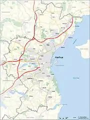
List of towns and cities in Aarhus Municipality
Statistics Denmark defines towns or cities as areas with more than 200 residents in a continuous settlement with no more than 200 meters between residential structures. In 2016 there were 20 such areas in Aarhus Municipality, the largest being the city of Aarhus with some 260.000 inhabitants while some 50.000 people lived in urban areas elsewhere in the municipality. In 2013 Beder and Malling were officially counted as a single conurbation for the first time.[1] Towns in the municipality are generally considered satellites of Aarhus.

Municipal map
Population by year[1]
| Name | 2010 | 2011 | 2012 | 2013 | 2014 | 2015 | 2016 | Coords |
|---|---|---|---|---|---|---|---|---|
| Aarhus Municipality | 306650 | 310956 | 314545 | 319094 | 323893 | 326246 | 330639 | 56°09′N 10°12′E |
| Aarhus | 242914 | 249709 | 252213 | 256018 | 259754 | 261570 | 264716 | 56°09′N 10°12′E |
| Lystrup | 10027 | 10363 | 10380 | 10376 | 10362 | 10341 | 10378 | 56°14′15.4″N 10°14′10.8″E |
| Beder-Malling | 0 | 0 | 0 | 8131 | 8194 | 8325 | 8365 | 56°02′58.3″N 10°11′59.6″E |
| Løgten | 6207 | 6334 | 6687 | 6967 | 7061 | 7335 | 7704 | 56°16′04.2″N 10°18′29.0″E |
| Mårslet | 4379 | 4481 | 4530 | 4772 | 4810 | 4877 | 4881 | 56°04′07.3″N 10°09′44.8″E |
| Harlev | 3508 | 3563 | 3648 | 3688 | 3691 | 3718 | 3707 | 56°08′42.4″N 9°59′49.9″E |
| Solbjerg | 3139 | 3144 | 3270 | 3446 | 3505 | 3551 | 3646 | 56°02′28.1″N 10°05′23.4″E |
| Hjortshøj | 2867 | 2876 | 2982 | 3047 | 3298 | 3463 | 3561 | 56°14′54.1″N 10°16′11.1″E |
| Sabro | 2474 | 2501 | 2640 | 2741 | 2807 | 2825 | 2928 | 56°12′41.7″N 10°02′12.5″E |
| Trige | 2701 | 2738 | 2748 | 2799 | 2847 | 2864 | 2869 | 56°15′04.9″N 10°08′36.4″E |
| Elev | 932 | 986 | 1014 | 1010 | 1110 | 1188 | 1215 | 56°14′22.9″N 10°11′51.7″E |
| Spørring | 927 | 946 | 953 | 936 | 965 | 976 | 986 | 56°17′51.4″N 10°08′52.5″E |
| Lisbjerg | 789 | 812 | 807 | 811 | 839 | 838 | 857 | 56°13′17.0″N 10°09′58.0″E |
| Studstrup | 890 | 891 | 883 | 879 | 853 | 854 | 851 | 56°15′28.6″N 10°20′30.7″E |
| Hårup | 758 | 775 | 767 | 763 | 749 | 763 | 806 | 56°17′11.1″N 10°13′04.1″E |
| Mejlby | 320 | 339 | 448 | 436 | 447 | 432 | 454 | 56°18′03.1″N 10°12′44.8″E |
| Mundelstrup | 430 | 441 | 464 | 399 | 386 | 396 | 395 | 56°11′51.8″N 10°03′51.1″E |
| Ormslev | 304 | 311 | 327 | 324 | 329 | 349 | 340 | 56°07′31.8″N 10°03′35.0″E |
| Borum | 364 | 356 | 355 | 329 | 326 | 330 | 321 | 56°11′16.5″N 10°00′45.0″E |
| Todbjerg | 227 | <200 | <200 | <200 | <200 | <200 | 204 | 56°16′04.1″N 10°12′27.1″E |
| Beder | 4332 | 4350 | 4372 | ** | ** | ** | ** | Beder-Malling since 2013 |
| Malling | 3462 | 3538 | 3694 | ** | ** | ** | ** | Beder-Malling since 2013 |
| Stavtrup | 3729 | * | * | * | * | * | * | Part of Aarhus since 2011 |
- Stavtrup was incorporated in Aarhus in 2011
- In 2013 Malling and Beder officially merged to form the new town of Beder-Malling
- Stavtrup was incorporated in Aarhus in 2011
References
- "BY1: Folketal 1. januar efter byområde, alder og køn" (in Danish). Danmarks Statistik. Retrieved 16 August 2015.
This article is issued from Wikipedia. The text is licensed under Creative Commons - Attribution - Sharealike. Additional terms may apply for the media files.