Listed buildings in Stevns Municipality
This is a list of listed buildings in Stevns Municipality, Denmark.
List
4600 Køge
| Listing name | Image | Location | Coordinates | Description |
|---|---|---|---|---|
| Slotsgade 3: Stiftskontoret | .jpg.webp) | Slotsgade 3, 4600 Køge | 55°24′3.01″N 12°12′38.42″E | [1] |
| Slotsgade 3, 4600 Køge | 55°24′3.01″N 12°12′38.42″E | [2] | ||
| Slotsgade 4: Vallø Castle (Vallø Adelige Stift) | 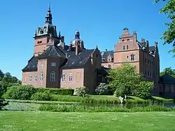 | Slotsgade 4, 4600 Køge | 55°24′8.09″N 12°12′39.69″E | [3] |
| Slotsgade 9: Lægeboligen | Slotsgade 9, 4600 Køge | 55°23′59.56″N 12°12′36.67″E | [4] | |
| Slotsgade 9, 4600 Køge | 55°23′59.56″N 12°12′36.67″E | [5] | ||
| Betjentboligen | Slotsgade 10, 4600 Køge | 55°24′3.73″N 12°12′37.06″E | Half timbered house from c. 1725[6] | |
| Slotsgade 10, 4600 Køge | 55°24′3.73″N 12°12′37.06″E | Later extension[7] | ||
| Slotsgade 12: Old Rectory, Vallø | Slotsgade 12, 4600 Køge | 55°24′2.93″N 12°12′37.54″E | Rectory from c. 1738[8] | |
| Vallø Old Rectory | Branddamsvej 1, 4600 Køge | 55°23′55.21″N 12°14′8.74″E | [9] | |
| Branddamsvej 1, 4600 Køge | 55°23′55.21″N 12°14′8.74″E | [10] | ||
| Branddamsvej 1, 4600 Køge | 55°23′55.21″N 12°14′8.74″E | [11] | ||
| Branddamsvej 1, 4600 Køge | 55°23′55.21″N 12°14′8.74″E | [12] | ||
4653 Karise
| Listing name | Image | Location | Coordinates | Description |
|---|---|---|---|---|
| Juellinge | Juellingevej 2, 4653 Karise | 55°18′7.12″N 12°14′5.31″E | Nain building[13] | |
| Juellingevej 2, 4653 Karise | 55°18′7.12″N 12°14′5.31″E | [14] | ||
| Juellingevej 2, 4653 Karise | 55°18′7.12″N 12°14′5.31″E | [15] | ||
4660 Store Heddinge
| Listing name | Image | Location | Coordinates | Description | source |
|---|---|---|---|---|---|
| Store Heddinge Savings Bank | Algade 11, 4660 Store Heddinge | 55°18′37.18″N 12°23′21.06″E | Bank building from 1925 designed by G.B. Hagen | Ref | |
| Gjorslev | 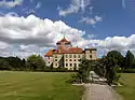 | Gjorslevvej 20, 4660 Store Heddinge | 55°21′14.41″N 12°22′50.63″E | Ref | |
|
| Gjorslevvej 20, 4660 Store Heddinge | 55°21′14.41″N 12°22′50.63″E | Ref | ||
| Stevns Lighthouse | 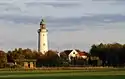 | Fyrvej 2, 4660 Store Heddinge | 1878 | New lighthouse | Ref |
| Fyrvej 2, 4660 Store Heddinge | 1818 | Old lighthouse | Ref | ||
| Ting- og Arresthus | 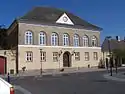 | Algade 8, 4660 Store Heddinge | 55°18′34.65″N 12°23′21.02″E | Ref | |
4672 Klippinge
| Listing name | Image | Location | Coordinates | Description |
|---|---|---|---|---|
| Andreassens Hospital | Borgergade 11, 4672 Klippinge | 55°22′1.02″N 12°20′21.66″E | Hospital building from 1742[16] | |
| Druebjerggård | Tåstrupvej 31, 4672 Klippinge | 55°20′9.14″N 12°17′5.95″E | [17] | |
| Magleby Kirkelade, Lindencrones Stiftelse | Kirkevænget 2, 4672 Klippinge | 55°21′47.56″N 12°20′16.05″E | [18] | |
| Trine's House | Tåstrupvej 33, 4672 Klippinge | 55°20′8.87″N 12°17′8.19″E | [19] | |
4673 Rødvig Stevns
| Listing name | Image | Location | Coordinates | Description |
|---|---|---|---|---|
| Lille Heddinge Rytterskole | Ryttervej 2, 4673 Rødvig Stevns | 55°16′24.61″N 12°23′21.83″E | Rytterskole from 1722[20] | |
| Østervang | Broveshøjvej 19, 4673 Rødvig Stevns | 55°16′24.27″N 12°23′39.06″E | [21] | |
References
- https://www.kulturarv.dk/fbb/sagvis.pub?sag=7630134
- https://www.kulturarv.dk/fbb/sagvis.pub?sag=7630134
- https://www.kulturarv.dk/fbb/sagvis.pub?sag=7630143
- https://www.kulturarv.dk/fbb/sagvis.pub?sag=7630148
- https://www.kulturarv.dk/fbb/sagvis.pub?sag=7630148
- https://www.kulturarv.dk/fbb/sagvis.pub?sag=7630140
- https://www.kulturarv.dk/fbb/sagvis.pub?sag=7630140
- https://www.kulturarv.dk/fbb/sagvis.pub?sag=7630137
- https://www.kulturarv.dk/fbb/sagvis.pub?sag=7630129
- https://www.kulturarv.dk/fbb/sagvis.pub?sag=7630129
- https://www.kulturarv.dk/fbb/sagvis.pub?sag=7630129
- https://www.kulturarv.dk/fbb/sagvis.pub?sag=7630129
- https://www.kulturarv.dk/fbb/sagvis.pub?sag=1534269
- https://www.kulturarv.dk/fbb/sagvis.pub?sag=1534269
- https://www.kulturarv.dk/fbb/sagvis.pub?sag=1534269
- https://www.kulturarv.dk/fbb/sagvis.pub?sag=1534283
- https://www.kulturarv.dk/fbb/sagvis.pub?sag=1534289
- https://www.kulturarv.dk/fbb/sagvis.pub?sag=1534279
- https://www.kulturarv.dk/fbb/sagvis.pub?sag=1534291
- https://www.kulturarv.dk/fbb/sagvis.pub?sag=1534266
- https://www.kulturarv.dk/fbb/sagvis.pub?sag=1534300
External links
| Wikimedia Commons has media related to Listed buildings in Stevns Kommune. |
This article is issued from Wikipedia. The text is licensed under Creative Commons - Attribution - Sharealike. Additional terms may apply for the media files.