Lomita, San Diego
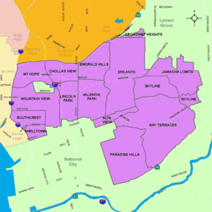
Lomita, also known as Lomita Village, is an urban neighborhood in the southeastern area of San Diego, California. It is bounded by Meadowbrook Drive to the west, Skyline Drive to the south, Cardiff Street to the east, and Jamacha Road to the north. Neighboring communities are Encanto, Paradise Hills, the city of Lemon Grove and the unincorporated community of Spring Valley. Major thoroughfares in the neighborhood include San Vicente Street and Worthington Avenue. The neighborhood is part of the Skyline-Paradise Hills Community Planning Area.[2]
Lomita, San Diego
Lomita Village, Jamacha-Lomita | |
|---|---|
| Lomita | |
.jpg.webp) 2014 aerial photo of the border of Jamacha-Lomita and Spring Valley | |
| Nickname(s): | |
 Lomita is located in the southeastern area of the city of San Diego | |
 Lomita, San Diego Location within Southeast San Diego | |
| Coordinates: 32.7087°N 117.0286°W | |
| Country | |
| State | |
| County | |
| City | |
| ZIP | 92114 |
Background
Lomita Village was largely built in the early 1950s and held a large military family population.[3] Lomita is a largely residential district, with some small-scale commercial development.[4]
Geography
The Skyline-Paradise Hills Community as a whole makes up approximately 4,500 acres. Much like the surrounding neighborhoods of Bay Terraces, Skyline, and Paradise Hills, Lomita is comprised predominantly of low-density single-family homes spread across the hilly area. A major geographic feature is Paradise Valley, which runs on an east-west axis through the middle of the community and gives rise to the Paradise Creek, which flows into San Diego Bay. Lomita, along with Jamacha, Skyline, and North Bay Terrace, are directly north of Paradise Valley.[5]
Demographics
Demographic statistics are only available for Lomita in conjunction with bordering Jamacha. Jamacha-Lomita is very diverse. Combined, the demographics for Jamacha-Lomita are as follows: Hispanic-Latino are the largest group at 51.1%, followed by African-Americans at 17.7%, Asian at 13.6%, non-Hispanic Whites at 13.0%, Mixed race at 3.9% and others at 0.7%.[6]
References
- "Skyline Piru (San Diego)". United Gangs. Retrieved 2020-11-21.
- ""Community Profiles: Skyline-Paradise Hills"". City of San Diego. Retrieved 2020-11-18.
- Lomita Village. City of San Diego.
- Skyline-Paradise Hills community plan. City of San Diego.
- "Skyline-Paradise Hills Community Plan". Scoutred. Retrieved 2020-11-25.
- ""Race and Ethnicity in Jomacha-Lomita, San Diego, California"". Statistical Atlas. Retrieved 2020-11-21.
