Loveland Pass
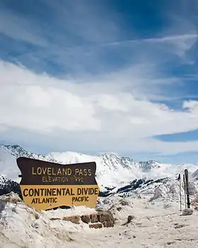
Loveland Pass is a high mountain pass in north-central Colorado, at an elevation of 11,990 feet (3,655 m) above sea level in the Rocky Mountains of the Western United States.
| Loveland Pass | |
|---|---|
 Loveland Pass in late March 2005 | |
| Elevation | 11,990 ft (3,655 m)[1] |
| Traversed by | |
| Location | Clear Creek / Summit counties, Colorado, U.S. |
| Range | Front Range |
| Coordinates | 39°39′49″N 105°52′45″W |
| Topo map | USGS Loveland Pass |
Background
It is located on the Continental Divide in the Front Range, west of Denver on U.S. Highway 6 (US 6). The twisty road is considered to be especially treacherous during the winter months. A steep, steady 6.7% grade, along with numerous hairpin turns on either side, make it difficult to snowplow the road regularly.
Loveland is the highest mountain pass in Colorado that regularly stays open during a snowy winter season.[2] When the Eisenhower Tunnel opened in March 1973, it allowed motorists on Interstate 70 (I-70) to avoid crossing the pass directly. Trucks that cannot pass through the tunnel (those carrying hazardous materials and those over 13 feet 11 inches (4.24 m) in height) must still take US 6 across Loveland Pass, 800 vertical feet (240 m) above the tunnel. The same is true for bicyclists, pedestrians, and those drivers who wish to stop along the road to admire the scenery.
Loveland Ski Area is located north west of the pass, and Arapahoe Basin is on the south/southeast side. The pass itself is a popular destination for backcountry skiers. Occasionally during the winter, the pass road may be closed by a blizzard and all traffic must use the tunnel, even the normally forbidden HAZMAT-carrying vehicles. In the event of less serious winter storms, chain restrictions are often imposed. At the Loveland Pass parking lot, visitors can access trails to the summits of Mount Sniktau and other nearby mountain peaks.[3][4]
The pass is named for William A.H. Loveland, the president of the Colorado Central Railroad and a resident of Golden during the late 19th century. The city of Loveland, in Larimer County near Fort Collins, is also named after him.[5]
Incidents
Plane crash
On a clear Friday in early October 1970, a plane crash occurred about two miles (3.2 km) north of the summit, and only nine of the 40 on board survived. The plane carried members of the Wichita State University football team, as well as coaches, administrators, and boosters. The cause was attributed to several pilot errors.
Gallery
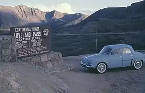 Loveland Pass, August 1964
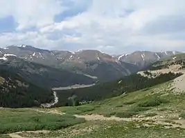 Looking east atop Loveland Pass in July 2007
See also
References
- "Loveland Pass". Geographic Names Information System. United States Geological Survey. Retrieved January 26, 2011.
- "CODOT: Avalanche Information Q & A". Colorado Department of Transportation. Retrieved October 24, 2017.
- "Mount Sniktau". Climbing, Hiking and Mountaineering. SummitPost.org. Retrieved November 30, 2012.
- "Mount Sniktau". Hiking in Colorado. Retrieved November 30, 2012.
- Dawson, John Frank. Place names in Colorado: why 700 communities were so named, 150 of Spanish or Indian origin. Denver: The J. Frank Dawson Publishing Co. p. 33.
- "Five Snowboarders Dead in Colorado Avalanche". Yahoo!-ABC News Network. April 20, 2013. Archived from the original on March 4, 2016. Retrieved December 26, 2016.
- Lazar, Brian (April 24, 2013). "2013/04/20 - Colorado - Sheep Creek, north of Loveland Pass". Colorado Avalanche Information Center. Retrieved October 31, 2019.
