Luray, Kansas
Luray is a city in Russell County, Kansas, United States.[6] As of the 2010 census, the city population was 194.[7]
Luray, Kansas | |
|---|---|
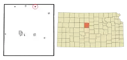 Location within Russell County and Kansas | |
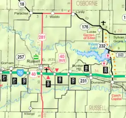 KDOT map of Russell County (legend) | |
| Coordinates: 39°6′50″N 98°41′29″W | |
| Country | United States |
| State | Kansas |
| County | Russell |
| Founded | 1870s |
| Incorporated | 1904 |
| Area | |
| • Total | 0.33 sq mi (0.86 km2) |
| • Land | 0.33 sq mi (0.86 km2) |
| • Water | 0.00 sq mi (0.00 km2) |
| Elevation | 1,562 ft (476 m) |
| Population | |
| • Total | 194 |
| • Estimate (2019)[3] | 184 |
| • Density | 554.22/sq mi (213.95/km2) |
| Time zone | UTC-6 (CST) |
| • Summer (DST) | UTC-5 (CDT) |
| ZIP code | 67649 |
| Area code | 785 |
| FIPS code | 20-43250 [4] |
| GNIS ID | 0472534 [5] |
History
Luray was established as the community of Lura in the 1870s. In 1887, the spelling of the town's name was changed to Luray.[8] Luray incorporated as a city in 1904.[9]
Geography
Luray is located at 39°6′50″N 98°41′29″W (39.114003, -98.691413)[10] at an elevation of 1,562 feet (476 m).[5] Located at the junction of U.S. Route 281 and Kansas Highway 18 (K-18) in north-central Kansas, Luray is 118 miles (190 km) northwest of Wichita, 218 miles (351 km) west of Kansas City, and 18 miles (29 km) northeast of Russell, the county seat.[6][11][12]
Located in the Smoky Hills region of the Great Plains, Luray sits on the north side of Wolf Creek, a tributary of the Saline River.[6][11] Coon Creek, a tributary of Wolf Creek, flows southeast along the eastern edge of the community.[11]
According to the United States Census Bureau, the city has a total area of 0.32 square miles (0.83 km2), all of it land.[13]
Climate
The climate in this area is characterized by hot, humid summers and generally mild to cool winters. According to the Köppen Climate Classification system, Luray has a humid subtropical climate, abbreviated "Cfa" on climate maps.[14]
Demographics
| Historical population | |||
|---|---|---|---|
| Census | Pop. | %± | |
| 1910 | 341 | — | |
| 1920 | 475 | 39.3% | |
| 1930 | 464 | −2.3% | |
| 1940 | 392 | −15.5% | |
| 1950 | 351 | −10.5% | |
| 1960 | 328 | −6.6% | |
| 1970 | 303 | −7.6% | |
| 1980 | 295 | −2.6% | |
| 1990 | 261 | −11.5% | |
| 2000 | 203 | −22.2% | |
| 2010 | 194 | −4.4% | |
| 2019 (est.) | 184 | [3] | −5.2% |
| U.S. Decennial Census | |||
2010 census
As of the 2010 census, there were 194 people, 94 households, and 61 families residing in the city. The population density was 646.7 people per square mile (249.7/km2). There were 134 housing units at an average density of 446.7 per square mile (167.5/km2). The racial makeup of the city was 97.9% White and 2.1% from two or more races. Hispanics and Latinos of any race were 1.5% of the population.[7]
There were 94 households, of which 17.0% had children under the age of 18 living with them, 58.5% were married couples living together, 1.1% had a male householder with no wife present, 5.3% had a female householder with no husband present, and 35.1% were non-families. 31.9% of all households were made up of individuals, and 17.0% had someone living alone who was 65 years of age or older. The average household size was 2.06, and the average family size was 2.48.[7]
In the city, the population was spread out, with 14.4% under the age of 18, 7.3% from 18 to 24, 17.5% from 25 to 44, 30.9% from 45 to 64, and 29.9% who were 65 years of age or older. The median age was 50.7 years. For every 100 females, there were 100 males. For every 100 females age 18 and over, there were 100 males age 18 and over.[7]
The median income for a household in the city was $36,563, and the median income for a family was $57,500. The per capita income for the city was $29,168. Males had a median income of $39,375 versus $42,813 for females. 1.5% of families and 5.6% of the population were below the poverty line, including 6.3% of those under age 18 and 3.9% of those age 65 or over.[7]
2000 census
As of the census[4] of 2000, there were 203 people, 105 households, and 57 families residing in the city. The population density was 665.1 people per square mile (252.8/km2). There were 134 housing units at an average density of 439.0 per square mile (166.9/km2). The racial makeup of the city was 97.54% White, 0.49% Native American, and 1.97% from two or more races. Hispanic or Latino of any race were 0.49% of the population.
There were 105 households, out of which 17.1% had children under the age of 18 living with them, 44.8% were married couples living together, 8.6% had a female householder with no husband present, and 44.8% were non-families. 42.9% of all households were made up of individuals, and 21.0% had someone living alone who was 65 years of age or older. The average household size was 1.93 and the average family size was 2.59.
In the city the population was spread out, with 16.7% under the age of 18, 4.9% from 18 to 24, 21.7% from 25 to 44, 25.6% from 45 to 64, and 31.0% who were 65 years of age or older. The median age was 51 years. For every 100 females, there were 75.0 males. For every 100 females age 18 and over, there were 76.0 males.
Economy
As of 2012, 58.9% of the population over the age of 16 was in the labor force. 0.0% was in the armed forces, and 58.9% was in the civilian labor force with 56.0% being employed and 2.9% unemployed. The composition, by occupation, of the employed civilian labor force was: 37.1% in management, business, science, and arts; 25.9% in natural resources, construction, and maintenance; 14.7% in production, transportation, and material moving; 14.7% in sales and office occupations; and 7.8% in service occupations. The three industries employing the largest percentages of the working civilian labor force were: educational services, and health care and social assistance (18.1%); professional, scientific, and management, and administrative and waste management services (17.2%); and manufacturing (17.2%).[7]
The cost of living in Luray is relatively low; compared to a U.S. average of 100, the cost of living index for the community is 78.0.[15] As of 2012, the median home value in the city was $33,500, the median selected monthly owner cost was $807 for housing units with a mortgage and $385 for those without, and the median gross rent was $288.[7]
Government
Luray is a city of the third class with a mayor-council form of government. The city council consists of five members, and it meets on the first Wednesday of each month.[16]
Luray lies within Kansas's 1st U.S. Congressional District. For the purposes of representation in the Kansas Legislature, the city is located in the 36th district of the Kansas Senate and the 109th district of the Kansas House of Representatives.[16]
Education
The community is served by Sylvan–Lucas USD 299 public school district, based in Sylvan Grove, Kansas.[17]
Previously, the city was served by Luray High School. The former school building that served as the Luray School and Luray-Lucas Elementary still stands at the corner of 4th Street and Russell County Avenue, in the northwest corner of the town. Lucas and Luray schools united in 1977 forming Lucas-Luray schools. Lucas-Luray was then united with Sylvan Unified schools in 2010 to form Sylvan-Lucas Unified.[18]
The Luray High School mascot was Luray Panthers.[19] Lucas-Luray High School mascot was the Cougars. Sylvan-Lucas is the Mustangs.[20]
The Luray Panthers won the Kansas State High School 8-Man Football championship in 1975.[21]
Infrastructure
Transportation
K-18 runs east-west along the northern edge of the city. U.S. Route 281, a north-south route, approaches Luray from the west concurrently with K-18, then turns north.[11] Bunker Hill-Luray Road, a paved north-south county road, enters the city from the south.[22]
Utilities
The city government provides electricity to local residents. Gorham Telephone provides landline telephone service and offers cable television and internet access.[23] Most residents use natural gas for heating fuel; service is provided by Kansas Gas Service.[15][23]
Media
Luray is in the Wichita-Hutchinson, Kansas television market.[24]
Culture
Events
The city of Luray holds an annual community festival, Friendship Day, on the sunday of Labor Day weekend. It includes a parade, an art show, golf and horseshoe tournaments, free barbecue, and homemade ice cream.[25] Annually since 1938, a local Methodist church has held another community event, the Luray Methodist Men's Fish Fry, on the third Friday evening of each March. Men from the church prepare and serve fried fish with trimmings and cherry pie, typically attracting hundreds from the surrounding area.[26]
References
- "2019 U.S. Gazetteer Files". United States Census Bureau. Retrieved July 24, 2020.
- "U.S. Census website". United States Census Bureau. Retrieved 2012-07-06.
- "Population and Housing Unit Estimates". United States Census Bureau. May 24, 2020. Retrieved May 27, 2020.
- "U.S. Census website". United States Census Bureau. Retrieved 2008-01-31.
- "US Board on Geographic Names". United States Geological Survey. 2007-10-25. Retrieved 2008-01-31.
- "2003-2004 Official Transportation Map" (PDF). Kansas Department of Transportation. 2003. Retrieved 2010-12-12.
- "U.S. Census website". United States Census Bureau. Retrieved 2011-08-18.
- Kansas State Historical Society (1916). Biennial Report of the Board of Directors of the Kansas State Historical Society. Kansas State Printing Plant. pp. 280.
- "Thirteenth Census of the United States : 1910 - V~1 Population". United States Census Bureau. Retrieved 2014-09-11.
- "US Gazetteer files: 2010, 2000, and 1990". United States Census Bureau. 2011-02-12. Retrieved 2011-04-23.
- "General Highway Map - Russell County, Kansas" (PDF). Kansas Department of Transportation. 2010-10-01. Retrieved 2010-12-12.
- "City Distance Tool". Geobytes. Archived from the original on 2010-10-05. Retrieved 2010-10-23.
- "US Gazetteer files 2010". United States Census Bureau. Archived from the original on 2012-01-25. Retrieved 2012-07-06.
- Climate Summary for Luray, Kansas
- "Luray, Kansas". City-Data.com. Retrieved 2014-09-11.
- "Luray". Directory of Kansas Public Officials. The League of Kansas Municipalities. Retrieved 2014-09-11.
- "USD 299 - History". USD 299. Retrieved 2011-08-20.
- "Kansas K-12 Reports". Kansas State Department of Education. Retrieved 30 December 2016.
- "Luray Panthers Continue Undefeated", The Salina Journal, 10 January 1971, p.16.
- "History". USD 299. Retrieved 31 December 2016.
- "Football". KSHSAA. Retrieved 1 January 2017.
- "Kansas Road Map Travel Guide". MilebyMile.com. 2009. Archived from the original on 2011-09-27. Retrieved 2010-12-11.
- "Utilities". Russell County, Kansas Economic Development & CVB. Retrieved 2014-09-11.
- "Kansas". TV Market Maps. EchoStar Knowledge Base. Archived from the original on 2011-07-26. Retrieved 2014-09-11.
- "Northwest Kansas Special Events". Northwest Kansas Travel Council, Inc. Retrieved 2011-08-21.
- "Events in Luray". Retrieved 2011-08-21.
- "Area Attractions". Russell Area Chamber of Commerce. Archived from the original on 2011-07-27. Retrieved 2011-08-23.
Further reading
External links
| Wikimedia Commons has media related to Luray, Kansas. |
Municipalities and communities of Russell County, Kansas, United States | ||
|---|---|---|
| Cities | 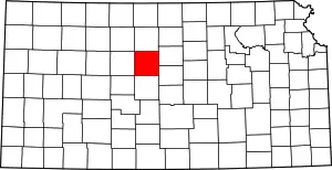 Map of Kansas highlighting Russell County | |
| Unincorporated communities | ||
| Ghost towns | ||
| Townships | ||
| Footnotes | ‡This populated place also has portions in an adjacent county or counties | |
| ||
