Lwówek Śląski County
Lwówek Śląski County (Polish: powiat lwówecki) is a unit of territorial administration and local government (powiat) in Lower Silesian Voivodeship, south-western Poland. It came into being on January 1, 1999, as a result of the Polish local government reforms passed in 1998. The county covers an area of 709.9 square kilometres (274.1 sq mi). Its administrative seat is the town of Lwówek Śląski, and it also contains the towns of Gryfów Śląski, Mirsk, Wleń and Lubomierz.
Lwówek Śląski County
Powiat lwówecki | |
|---|---|
 Flag  Coat of arms | |
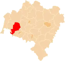 Location within the voivodeship | |
| Coordinates: 51°7′N 15°35′E | |
| Country | |
| Voivodeship | Lower Silesian |
| Seat | Lwówek Śląski |
| Gminas | |
| Area | |
| • Total | 709.94 km2 (274.11 sq mi) |
| Population (2019-06-30[1]) | |
| • Total | 45,975 |
| • Density | 65/km2 (170/sq mi) |
| • Urban | 23,129 |
| • Rural | 22,846 |
| Car plates | DLW |
| Website | https://powiatlwowecki.pl/ |
As of 2019 the total population of the county is 45,975, the most populated towns are Lwówek Śląski with 8,869 inhabitants and Gryfów Śląski with 6,636 inhabitants.
Neighbouring counties
Lwówek Śląski County is bordered by Lubań County to the west, Bolesławiec County to the north, Złotoryja County to the east and Jelenia Góra County to the south. It also borders the Czech Republic to the south.
Administrative division
The county is subdivided into five gminas (all of them urban-rural, centred on the five towns). These are listed in the following table, in descending order of population.
| Gmina | Type | Area (km²) |
Population (2019) |
Seat |
| Gmina Lwówek Śląski | urban-rural | 240.4 | 17,239 | Lwówek Śląski |
| Gmina Gryfów Śląski | urban-rural | 66.6 | 9,697 | Gryfów Śląski |
| Gmina Mirsk | urban-rural | 186.6 | 8,622 | Mirsk |
| Gmina Lubomierz | urban-rural | 130.4 | 6,192 | Lubomierz |
| Gmina Wleń | urban-rural | 86.0 | 4,225 | Wleń |
References
- "Population. Size and structure and vital statistics in Poland by territorial divison in 2019. As of 30th June". stat.gov.pl. Statistics Poland. 2019-10-15. Retrieved 2020-02-14.
Seat: Lwówek Śląski | ||
| Urban-rural gminas | | |
| City counties |
|  |
|---|---|---|
| Land counties | ||