Lyndeborough, New Hampshire
Lyndeborough /ˈlaɪndˌbʌroʊ/ is a town in Hillsborough County, New Hampshire, United States. The population was 1,683 at the 2010 census.[1]
Lyndeborough, New Hampshire | |
|---|---|
Town | |
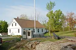 1846 Town Hall | |
 Seal | |
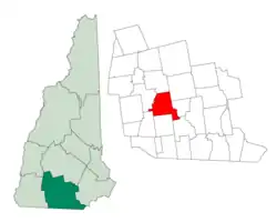 Location in Hillsborough County, New Hampshire | |
| Coordinates: 42°54′27″N 71°45′59″W | |
| Country | United States |
| State | New Hampshire |
| County | Hillsborough |
| Incorporated | 1764 |
| Villages | Lyndeborough South Lyndeborough |
| Government | |
| • Board of Selectmen | Mark A. Chamberlain, Chair Rick McQuade Fred G. Douglas |
| • Town Administrator | Russ Boland |
| Area | |
| • Total | 30.5 sq mi (79.1 km2) |
| • Land | 30.4 sq mi (78.8 km2) |
| • Water | 0.1 sq mi (0.3 km2) 0.38% |
| Elevation | 883 ft (269 m) |
| Population (2010) | |
| • Total | 1,683 |
| • Density | 55/sq mi (21/km2) |
| Time zone | UTC-5 (Eastern) |
| • Summer (DST) | UTC-4 (Eastern) |
| ZIP code | 03082 |
| Area code(s) | 603 |
| FIPS code | 33-44580 |
| GNIS feature ID | 0873655 |
| Website | town |
History
Originally granted by the Massachusetts General Court to veterans of New England's first war with Canada from Salem, Massachusetts, the area was known as Salem-Canada. John Cram and his family were the first settlers, and established a sawmill in the community in 1736.[2] The name Lyndeborough resulted from a re-grant to a group of people that included Benjamin Lynde, who later became Chief Justice of Massachusetts. This group of proprietors never lived in Lyndeborough and may never have visited the community. For instance, while serving as a proprietor of Lyndeborough, Judge Lynde lived in Massachusetts, where he presided in Suffolk County over the trial stemming from the Boston Massacre.[3]
The town has been home to the Lafayette Artillery Company (founded 1804) since 1833. The town office building, Citizens' Hall (opened 1889), is listed on the National Register of Historic Places, as is the Lyndeborough Center Historic District, which consists of the Congregational Church (circa 1836), Town Hall (1846), and remnants of the Town Pound (1774).
Geography
According to the United States Census Bureau, the town has a total area of 30.5 square miles (79 km2), of which 30.4 square miles (79 km2) is land and 0.1 square miles (0.26 km2) is water, comprising 0.38% of the town.[4] The highest point in Lyndeborough is just shy of 1,800 feet (550 m) above sea level, where the east ridge of North Pack Monadnock Mountain crosses the town's western border. Notable summits in town include Winn Mountain (1,686 ft or 514 m), Rose Mountain (1,730 ft or 530 m), and The Pinnacle (1,703 ft or 519 m). The town is crossed by state route 31.
Adjacent municipalities
- Francestown, New Hampshire (north)
- New Boston, New Hampshire (northeast)
- Mont Vernon, New Hampshire (east)
- Milford, New Hampshire (southeast)
- Wilton, New Hampshire (south)
- Temple, New Hampshire (southwest)
- Greenfield, New Hampshire (west)
Demographics
| Historical population | |||
|---|---|---|---|
| Census | Pop. | %± | |
| 1790 | 1,280 | — | |
| 1800 | 976 | −23.7% | |
| 1810 | 1,074 | 10.0% | |
| 1820 | 1,168 | 8.8% | |
| 1830 | 1,147 | −1.8% | |
| 1840 | 1,033 | −9.9% | |
| 1850 | 968 | −6.3% | |
| 1860 | 823 | −15.0% | |
| 1870 | 820 | −0.4% | |
| 1880 | 818 | −0.2% | |
| 1890 | 657 | −19.7% | |
| 1900 | 686 | 4.4% | |
| 1910 | 660 | −3.8% | |
| 1920 | 428 | −35.2% | |
| 1930 | 399 | −6.8% | |
| 1940 | 452 | 13.3% | |
| 1950 | 552 | 22.1% | |
| 1960 | 594 | 7.6% | |
| 1970 | 789 | 32.8% | |
| 1980 | 1,070 | 35.6% | |
| 1990 | 1,294 | 20.9% | |
| 2000 | 1,585 | 22.5% | |
| 2010 | 1,683 | 6.2% | |
| 2017 (est.) | 1,716 | [5] | 2.0% |
| U.S. Decennial Census[6] | |||
As of the census[7] of 2000, there were 1,585 people, 560 households, and 420 families residing in the town. The population density was 51.0 people per square mile (19.7/km2). There were 587 housing units at an average density of 18.9 per square mile (7.3/km2). The racial makeup of the town was 98.17% White, 0.19% African American, 0.13% Native American, 0.32% Asian, 0.38% from other races, and 0.82% from two or more races. Hispanic or Latino of any race were 1.64% of the population.
There were 560 households, out of which 37.1% had children under the age of 18 living with them, 67.7% were married couples living together, 4.8% had a female householder with no husband present, and 25.0% were non-families. 16.4% of all households were made up of individuals, and 5.7% had someone living alone who was 65 years of age or older. The average household size was 2.83 and the average family size was 3.20.
In the town, the population was spread out, with 26.9% under the age of 18, 6.3% from 18 to 24, 32.6% from 25 to 44, 27.3% from 45 to 64, and 6.9% who were 65 years of age or older. The median age was 38 years. For every 100 females, there were 102.9 males. For every 100 females age 18 and over, there were 99.8 males.
The median income for a household in the town was $59,688, and the median income for a family was $70,223. Males had a median income of $37,941 versus $29,327 for females. The per capita income for the town was $27,169. About 1.2% of families and 3.3% of the population were below the poverty line, including 3.0% of those under age 18 and 8.4% of those age 65 or over.
Notable inhabitants
- William Barron, United States Marshal for the District of Vermont[8][9]
- Eddie Mottau, guitarist
- Willard Parker, pioneering surgeon
Sites of interest
References
- United States Census Bureau, U.S. Census website, 2010 Census figures. Retrieved March 23, 2011.
- New Hampshire Economic and Labor Market Information Profile Bureau
- Coolidge, Austin J.; John B. Mansfield (1859). A History and Description of New England. Boston, Massachusetts: A.J. Coolidge. pp. 562.
coolidge mansfield history description new england 1859.
- "Geographic Identifiers: 2010 Demographic Profile Data (G001) – Lyndeborough town, New Hampshire". United States Census Bureau. Retrieved November 14, 2011.
- "Annual Estimates of the Resident Population: April 1, 2010 to July 1, 2017 (PEPANNRES): Minor Civil Divisions – New Hampshire". Archived from the original on February 13, 2020. Retrieved November 15, 2018.
- "Census of Population and Housing". Census.gov. Retrieved June 4, 2016.
- "U.S. Census website". United States Census Bureau. Retrieved 2008-01-31.
- "New Hampshire Births and Christenings Index, 1714-1904, Entry for William Barron". Ancestry.com. Lehi, UT: Ancestry.com, LLC. Retrieved February 2, 2020.
- McKeen, Silas (1875). A History of Bradford, Vermont. Montpelier, VT: J. D. Clark & Son. pp. 191–193 – via Internet Archive.
External links
- Town of Lyndeborough official website
- J. A. Tarbell Library
- New Hampshire Economic and Labor Market Information Bureau Profile
Places adjacent to Lyndeborough, New Hampshire | ||||||||||
|---|---|---|---|---|---|---|---|---|---|---|
| ||||||||||
Municipalities and communities of Hillsborough County, New Hampshire, United States | ||
|---|---|---|
| Cities | 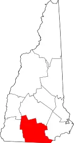 Map of New Hampshire highlighting Hillsborough County | |
| Towns | ||
| CDPs | ||
| Other villages | ||
| ||
| Authority control |
|---|