Mönichkirchen
Mönichkirchen is a market town in the district of Neunkirchen in the south of the Austrian state of Lower Austria with a population of 607 inhabitants (1.1.2013).
Mönichkirchen | |
|---|---|
 Coat of arms | |
 Mönichkirchen Location within Austria | |
| Coordinates: 47°30′N 16°2′E | |
| Country | Austria |
| State | Lower Austria |
| District | Neunkirchen |
| Government | |
| • Mayor | Andreas Graf |
| Area | |
| • Total | 16.31 km2 (6.30 sq mi) |
| Elevation | 967 m (3,173 ft) |
| Population (2018-01-01)[2] | |
| • Total | 606 |
| • Density | 37/km2 (96/sq mi) |
| Time zone | UTC+1 (CET) |
| • Summer (DST) | UTC+2 (CEST) |
| Postal code | 2872 |
| Area code | 02649 |
| Website | www.moenichkirchen.at |
Geography
Mönichkirchen is situated on the east side of the Wechsel mountain (1,743 m) in the south-east Industrieviertel near the border with Styria. The size of the village is 16.27 km². 68.34% of the area is forested.
Population
| Year | Pop. | ±% |
|---|---|---|
| 1869 | 479 | — |
| 1880 | 546 | +14.0% |
| 1890 | 540 | −1.1% |
| 1900 | 526 | −2.6% |
| 1910 | 615 | +16.9% |
| 1923 | 579 | −5.9% |
| 1934 | 662 | +14.3% |
| 1939 | 646 | −2.4% |
| 1951 | 669 | +3.6% |
| 1961 | 752 | +12.4% |
| 1971 | 782 | +4.0% |
| 1981 | 741 | −5.2% |
| 1991 | 721 | −2.7% |
| 2001 | 623 | −13.6% |
| 2011 | 597 | −4.2% |
Sports
There are two sports clubs at Mönichkirchen:
- Winter sports club Mönichkirchen
- Soccer club FC Mönichkirchen
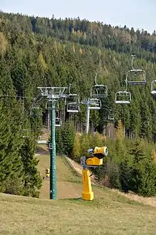
Around the village of Mönichkirchen there is a skiing resort that is joined by several lifts to the adjacent skiing resort of Mariensee (village of Aspangberg-Sankt Peter). The total length of ski-slopes of both resorts is about 13 km. Both villages operate three chair lifts and one drag lift.
During summer the region is commonly used for hiking and climbing.
References
- "Dauersiedlungsraum der Gemeinden Politischen Bezirke und Bundesländer - Gebietsstand 1.1.2018". Statistics Austria. Retrieved 10 March 2019.
- "Einwohnerzahl 1.1.2018 nach Gemeinden mit Status, Gebietsstand 1.1.2018". Statistics Austria. Retrieved 9 March 2019.
| Authority control |
|---|