M6 motorway (Hungary)
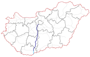
The M6 motorway (Hungarian: M6-os autópálya) is a north-south motorway in Hungary running along the Danube connecting Budapest to the seat of Baranya county Pécs, and further south to the Croatian border.
| |
|---|---|
| M6-os autópálya | |
 | |
| Route information | |
| Part of | |
| Length | 193 km (120 mi) 212 km (132 mi) planned |
| Major junctions | |
| From | |
| To | Ivándárda |
| Location | |
| Counties | Pest, Fejér, Tolna, Baranya |
| Major cities | Budapest, Érd, Dunaújváros, Paks, Szekszárd, Mohács |
| Highway system | |
_Otszogletu_kek_tabla.svg.png.webp)

M6 near Ráckeresztúr

M6 124km
The southernmost Bóly - Ivándárda (border crossing with Croatia) section will be built last, at the same time as the connecting segment of the A5 in Croatia, the completion of the A5 is scheduled for 2023. [1]
Municipalities
The M6 motorway runs through the following municipalities:
- Budapest, Érd, Százhalombatta
- Ercsi, Ráckeresztúr, Besnyő, Beloiannisz, Iváncsa, Adony, Kulcs, Rácalmás, Dunaújváros, Baracs, Daruszentmiklós, Előszállás
- Dunaföldvár, Bölcske, Paks, Dunaszentgyörgy, Fadd, Tengelic, Tolna, Fácánkert, Szedres, Szekszárd, Őcsény, Decs, Sárpilis, Várdomb, Alsónyék, Bátaszék
- Véménd, Palotabozsok, Szebény, Szűr, Himesháza, Székelyszabar, Kisnyárád, Lánycsók, Babarc
Openings timeline
- Budapest; M0 – Érdi-tető (7 km): 2008.09.23.
- Érdi-tető – Dunaújváros; M8 (68 km): 2006.06.11.
- Dunaújváros; M8 – Bóly; M60 (118 km): 2010.03.31.
Junctions, exits and rest areas
- Distance from Zero Kilometre Stone (Adam Clark Square) in Budapest in kilometres.
| M0 (Budapest) – Ivándárda (212 km) | ||||
| 15 km | Győr, Nagykanizsa / Szeged, Nyíregyháza Budapest International Airport | Budapest bypass | ||
| 18 km | Érd east / Budapest-Nagytétény | |||
| 20 km | Érd-Ófalu | |||
| 22 km | Érdi-tető | |||
| 25 km | Százhalombatta north | |||
| 29 km | Százhalombatta south | |||
| 31 km | Keresztúri rest area | |||
| 34 km | Ráckeresztúr, Martonvásár / Ercsi | 6204 | ||
| 40 km | Fácános rest area | |||
| 45 km | Besenyő, Pusztaszabolcs / Beloiannisz | 6205 | ||
| 50 km | Iváncsa / Pusztaszabolcs, Velence | 6207 | ||
| 55 km | Adony / Perkáta | 6208 | ||
| 57 km | Szentmihályi rest area | |||
| 62 km | Kulcs, Rácalmás | |||
| 67 km | Dunaújváros north / Székesfehérvár | |||
| 70 km | Dunaújváros / Mezőfalva, Sárbogárd | 6219 | ||
| 71 km | Újvárosi rest area | |||
| 75 km | Dunaújváros south, Szolnok / Szentgotthárd | M8 | ||
| 83 km | Dunaföldvár north / Daruszentmiklós, Seregélyes | 6228 | ||
| 87 km | Dunaföldvár, Solt / Előszállás, Nagykanizsa | |||
| 92 km | Dunaföldvári rest area | |||
| 98 km | Dunaföldvár south, Paks north (Gabonásvölgy junction) | |||
| Gyűrűs-árok | ||||
| Vörösmalmi-árok | ||||
| 106 km | Paks / Németkér, Cece | 6231 | ||
| 108 km | Paksi rest area | |||
| 114 km | Paks south | 6232 | ||
| 120 km | Szentgyörgyi rest area | |||
| 124 km | Tengelic / Dunaszentgyörgy, Fadd | 6234 | ||
| 131 km | Szedres | 631 | ||
| 134 km | Fácánkerti rest area | |||
| 138 km | Tolna | |||
| 142 km | Szombathely, Nagykanizsa, Kaposvár / Szeged | M9 turns toward -> Szombathely or Szeged | ||
| Sió River | ||||
| 147 km | Szekszárd Centrum | 5113 | ||
| 151 km | Szekszárd south / Őcsény | 5114 | ||
| 155 km | Szentgyörgyi rest area | |||
| 164 km | Bonyhád / Bátaszék, Baja | |||
| 165 km | Geresdi rest area | |||
| 167-68 km | Bátaszék Tunnel "A" | Tunnel - 1331 m | ||
| 169 km | Belső-réti patak Viaduct | Bridge - 280 m | ||
| 169 km | Geresd Tunnel "B" | Tunnel - 399 m | ||
| 170 km | Belső-réti patak Viaduct | Bridge - 313 m | ||
| 170-71 km | Baranya Tunnel "C" | Tunnel - 865 m | ||
| 172 km | Véménd Tunnel "D" | Tunnel - 418 m | ||
| 173 km | Palotabozsoki-vízfolyás Viaduct | Bridge - 481 m | ||
| Véménd, Pécsvárad / Palotabozsok, Somberek | 5606 | |||
| Szebény Viaduct | Bridge - 830 m | |||
| 181 km | Szebényi rest area | |||
| Csele patak Viaduct | Bridge - 450 m | |||
| Himesházai-árok Viaduct | Bridge - 491 m | |||
| 191 km | Lánycsók, Mohács / Babarc | |||
| 193 km | Pécs, Barcs | M60 turns toward -> | ||
| Signs | Distance | Destinations | Note |
|---|---|---|---|
| (196 km) | Nagynyárád, Bóly - East | ||
| (210 km) | Ivándárda, Kislippó | ||
| Ivándárda / Branjin Vrh border crossing | |||
| Osijek, |
Toll
From February 1, 2015, the M6 motorway is fully charged. The motorway can be used instead of the national sticker with the following county stickers:
| Type of vignette | Available section |
|---|---|
| Pest County | between M0 expressway junction and Ráckeresztúr (15 km – 34 km) |
| Fejér County | between Százhalombatta north and Paks north (25 km – 98 km) |
| Tolna County | between M8 motorway junction and Pécsvárad (Somberek) (75 km – 173 km) |
| Baranya County | between Bátaszék and Bóly west (163 km – 191 km) |
Significant artifacts
From Budapest to the Croatian border, the M6 motorway features the following bridges, tunnels or covered cuts:
- Viaduct
- Belső-réti patak Viaduct (Belső-réti patak völgyhíd I.; 280 m or 920 ft)
- Belső-réti patak Viaduct (Belső-réti patak völgyhíd II.; 313 m or 1,027 ft)
- Palotabozsoki-vízfolyás Viaduct (Palotabozsoki-vízfolyás völgyhíd; 481 m or 1,578 ft)
- Szebény Viaduct (Szebényi völgyhíd; 830 m or 2,720 ft)
- Csele patak Viaduct (Csele-patak völgyhíd; 450 m or 1,480 ft)
- Himesházai árok Viaduct (Himesházai árok völgyhíd; 491 m or 1,611 ft)
- Tunnel
- Bátaszék Tunnel (Bátaszék alagút "A"; 1,331 m or 4,367 ft) – Longest tunnel in Hungary
- Geresd Tunnel (Geresd alagút "B"; 399 m or 1,309 ft)
- Baranya Tunnel (Baranya alagút "C"; 865 m or 2,838 ft)
- Véménd Tunnel (Véménd alagút "D"; 418 m or 1,371 ft)
European Route
| Name | Route | |
| 197 km | ||
References
- "A5 Brochure 2018" (PDF). Retrieved 29 January 2019.
External links
| Wikimedia Commons has media related to Autópálya M6. |
- National Toll Payment Services Plc. (in Hungarian, some information also in English)
- National Infrastructure Developer Ltd. (in Hungarian)
- Exit list of M6 in motorways-exitlists.com
- Construction works of the new section
This article is issued from Wikipedia. The text is licensed under Creative Commons - Attribution - Sharealike. Additional terms may apply for the media files.