Maer, Cornwall
Maer is a coastal hamlet in north Cornwall, England, United Kingdom. It is situated one mile (1.6 km) northeast of Bude at grid reference SS 205 075[1] in the civil parish of Bude-Stratton (where the 2011 census population is included.).
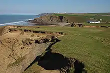
Maer Cliff, Cornwall
The National Trust maintains Maer Down and Maer Cliff immediately west of the hamlet. The South West Coast Path runs along the clifftop past Maer.[1]
References
- Ordnance Survey: Landranger map sheet 190 Bude & Clovelly ISBN 978-0-319-23145-6
Cornwall Portal | |
| Unitary authorities | |
| Major settlements |
|
| Rivers | |
| Topics | |
This article is issued from Wikipedia. The text is licensed under Creative Commons - Attribution - Sharealike. Additional terms may apply for the media files.