Magallanes, Sorsogon
Magallanes, officially the Municipality of Magallanes, is a 2nd class municipality in the province of Sorsogon, Philippines. According to the 2015 census, it has a population of 37,038 people. [3]
Magallanes | |
|---|---|
| Municipality of Magallanes | |
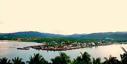 Aerial view of Magallanes | |
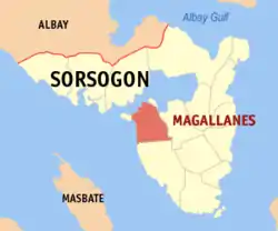 Map of Sorsogon with Magallanes highlighted | |
OpenStreetMap 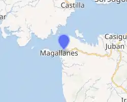
| |
.svg.png.webp) Magallanes Location within the Philippines | |
| Coordinates: 12°50′N 123°51′E | |
| Country | |
| Region | Bicol Region (Region V) |
| Province | Sorsogon |
| District | 1st district |
| Founded | 1567 |
| Named for | Fernando Magallanes |
| Barangays | 34 (see Barangays) |
| Government | |
| • Type | Sangguniang Bayan |
| • Mayor | Augusto Manuel M. Ragragio |
| • Vice Mayor | Allen A. Arambulo |
| • Representative | Evelina G. Escudero |
| • Electorate | 22,949 voters (2019) |
| Area | |
| • Total | 150.09 km2 (57.95 sq mi) |
| Elevation | 24 m (79 ft) |
| Population | |
| • Total | 37,038 |
| • Density | 250/km2 (640/sq mi) |
| • Households | 7,470 |
| Demonym(s) | Magalleño |
| Economy | |
| • Income class | 3rd municipal income class |
| • Poverty incidence | 45.04% (2015)[4] |
| • Revenue | ₱101,106,151.90 (2016) |
| Time zone | UTC+8 (PST) |
| ZIP code | 4705 |
| PSGC | |
| IDD : area code | +63 (0)56 |
| Climate type | tropical rainforest climate |
| Native languages | Sorsoganon Tagalog |
| Website | www |
According to renowned historians and anthropologists such as Domingo Abella, Luis Camara Dery, Merito Espinas, F. Mallari, Norman Owen, Mariano Goyena del Prado, et al., Magallanes is also the present location of the ancient settlement of Ibalong.[5][6][7][8][9][10][11]
History
In 1569, the Jimenez-Orta expedition landed at Barangay Ginangra near the village of Gibal-ong, the site where the first mass in the island of Luzon was said, the site of the first Christian settlement. Magallanes started as settlement called Parina, a name derived from the hardwood tree reputed to be so durable as to last for centuries that was known to abound in the place long before it became a barrio of Pueblo de Casiguran under the old province of Albay.
This settlement was not spared from sporadic sorties launched by punitive bands from the south, that in 1854 one group of that band ravage Ginangra and took as hostage one family from the village. As a counter-measure, the Spanish Comandancia of Parina constructed a watchtowers in such strategic places as Telegrapo and Bagatao which were equipped with cannons and manned around the clock. Cannon also were mounted in Cañonera the present site of Binisitahan del Norte at the mouth of Incarizan River.
On July 16, 1860 the name Parina was changed to Magallanes in honor of the Portuguese who discovered the Philippines island in 1521 Ferdinand Magellan.[12] Magallanes was officially declared a pueblo with Don Manuel de Castro as its first appointed governadorcillo. In 1864 the Parish of our Lady of Mt. Carmel was canonically established with Rev. Fr. Higino de Castro as its first pastor. It was during this year that the first census was conducted resulting to a total count of 1400 inhabitants. Moreover, the town was split into six cabeseras each of which was entrusted to the administrative supervision of a cebeja de barangay.
Pursuant to the decree of the Spanish Crown, new official with new corresponding titles were elected. Don Juan de Castro was chosen as the first Capitan Municipal in 1894. In 1901 the municipality elected its first set of official under the American. Don Inocencio M. Mella was elected Presidente Municipal under the Malolos Constitution. [13]
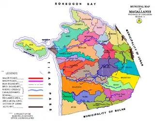
Barangays
Magallanes is politically subdivided into 34 barangays.
- Aguada Norte
- Aguada Sur
- Anibong
- Bacalon
- Bacolod
- Banacud
- Biga
- Behia
- Binisitahan del Norte
- Binisitahan del Sur
- Biton
- Bulala
- Busay
- Caditaan
- Cagbolo
- Cagtalaba
- Cawit Extension
- Cawit Proper
- Ginangra
- Hubo
- Incarizan
- Lapinig
- Magsaysay
- Malbog
- Pantalan
- Pawik
- Pili
- Poblacion
- Salvacion
- Santa Elena
- Siuton
- Tagas
- Tulatula Norte
- Tulatula Sur
Demographics
| Year | Pop. | ±% p.a. |
|---|---|---|
| 1903 | 4,921 | — |
| 1918 | 10,012 | +4.85% |
| 1939 | 15,412 | +2.08% |
| 1948 | 17,982 | +1.73% |
| 1960 | 18,144 | +0.07% |
| 1970 | 23,896 | +2.79% |
| 1975 | 23,101 | −0.68% |
| 1980 | 25,765 | +2.21% |
| 1990 | 24,754 | −0.40% |
| 1995 | 28,707 | +2.81% |
| 2000 | 31,315 | +1.88% |
| 2007 | 34,418 | +1.31% |
| 2010 | 35,443 | +1.07% |
| 2015 | 37,038 | +0.84% |
| Source: Philippine Statistics Authority [3] [14] [15][16] | ||
| Barangay | Population (2007) | Population (2010) |
|---|---|---|
| 1,540 | 1,533 | |
| 1,111 | 1,142 | |
| 434 | 471 | |
| 604 | 603 | |
| 1,012 | 992 | |
| 1,340 | 1,375 | |
| 1,152 | 1,147 | |
| 2,321 | 2,336 | |
| 835 | 871 | |
| 684 | 647 | |
| 1,973 | 1,982 | |
| 478 | 497 | |
| 460 | 486 | |
| 3,151 | 3,157 | |
| 939 | 1,047 | |
| 511 | 539 | |
| 1,420 | 1,591 | |
| 1,018 | 1,051 | |
| 629 | 715 | |
| 809 | 802 | |
| 1,362 | 1,360 | |
| 680 | 692 | |
| 243 | 239 | |
| 342 | 382 | |
| 1,245 | 1,249 | |
| 647 | 660 | |
| 1,293 | 1,302 | |
| 613 | 617 | |
| 888 | 1,041 | |
| 1,063 | 1,073 | |
| 1,703 | 1,828 | |
| 508 | 511 | |
| 767 | 860 | |
| 643 | 645 |
Climate
| Climate data for Magallanes, Sorsogon | |||||||||||||
|---|---|---|---|---|---|---|---|---|---|---|---|---|---|
| Month | Jan | Feb | Mar | Apr | May | Jun | Jul | Aug | Sep | Oct | Nov | Dec | Year |
| Average high °C (°F) | 27 (81) |
28 (82) |
29 (84) |
31 (88) |
31 (88) |
30 (86) |
29 (84) |
29 (84) |
29 (84) |
29 (84) |
29 (84) |
28 (82) |
29 (84) |
| Average low °C (°F) | 22 (72) |
21 (70) |
22 (72) |
23 (73) |
24 (75) |
25 (77) |
25 (77) |
25 (77) |
25 (77) |
24 (75) |
23 (73) |
23 (73) |
24 (74) |
| Average precipitation mm (inches) | 65 (2.6) |
44 (1.7) |
42 (1.7) |
39 (1.5) |
87 (3.4) |
150 (5.9) |
184 (7.2) |
153 (6.0) |
163 (6.4) |
154 (6.1) |
127 (5.0) |
100 (3.9) |
1,308 (51.4) |
| Average rainy days | 13.9 | 9.2 | 11.0 | 12.5 | 19.6 | 24.3 | 26.5 | 25.0 | 25.5 | 24.4 | 19.4 | 15.1 | 226.4 |
| Source: Meteoblue [17] | |||||||||||||
Economy

Magallanes is primary considered a coastal town as 24 of its 34 barangays are situated along the seashore and with the abundant marine resource, the natives take to the sea daily for their food and livelihood.
Marine and fishpond fishing are the town's prime industry despite large agricultural lands being engaged as well in crop and livestock production. Fish drying is a common practice among the locals after which the produce is sold to neighboring towns. For the fishpond culture, they are able to produce milkfish, tilapia, prawns and mud crab. The variety of ways the marine and inland fishing produce are processed include sardine in oil, bangus in oil, dried posit, dilis tuyo, daing and tinapa.
Sardine and Bangus in Oil are OTOP products processed by the Magallanes Food Products[18][19] while the dried and smoke fish are processed by the Bacolod Women's Cooperative and by the fish folks themselves.
Crops production of rice, corn, coconut, fruit trees, vegetables and root cops make an abundant produce for the town. Of these crops, coconut accounts about 96.15% making it the dominant major product.[20]
References
- Municipality of Magallanes | (DILG)
- "Province: Sorsogon". PSGC Interactive. Quezon City, Philippines: Philippine Statistics Authority. Retrieved 12 November 2016.
- Census of Population (2015). "Region V (Bicol Region)". Total Population by Province, City, Municipality and Barangay. PSA. Retrieved 20 June 2016.
- "PSA releases the 2015 Municipal and City Level Poverty Estimates". Quezon City, Philippines. Retrieved 1 January 2020.
- Abella, D. (1954). Bikol Annals: A Collection of Vignettes of Philippine History. Manila.
- Dery, L. C. (1991). From Ibalon to Sorsogon : A Historical Survey of Sorsogon Province to 1905. Quezon City: New Day Publishers.
- Espinas, M. (1996). The Ibalong : The Bikol Folk Epic-fragment. Manila: University of Santo Tomas Publishing House.
- Mallari, F. (1990). Ibalon Under Storm and Siege : Essays on Bicol History: 1565-1860. Cagayan de Oro City.
- Owen, N. (1999). The Bikol blend : Bikolanos and Their History. Quezon City: New Day Publishers.
- Prado, M. G. (1981). Ibalon : Ethnohistory of the Bikol Region. Legazpi City: AMS Press.
- Reyes, J. C. (January–February 1979). The Ibalen Epic - A Window to Bicols Pre-history. Boletin Eclesiastico de Filipinas v. 53 nos. 590-591, pp. 61-92.
- page 24, Tracing from Solsogon to Sorsogon, 2nd Edition (2007), ISBN 978-971-814-099-4
- based on the unpublished work of Ma. Terera Carranza Hadap
- Census of Population and Housing (2010). "Region V (Bicol Region)". Total Population by Province, City, Municipality and Barangay. NSO. Retrieved 29 June 2016.
- Censuses of Population (1903–2007). "Region V (Bicol Region)". Table 1. Population Enumerated in Various Censuses by Province/Highly Urbanized City: 1903 to 2007. NSO.
- "Province of Sorsogon". Municipality Population Data. Local Water Utilities Administration Research Division. Retrieved 17 December 2016.
- "Magallanes, Sorsogon : Average Temperatures and Rainfall". Meteoblue. Retrieved 29 December 2018.
- http://www.ourchurch.com/member/m/magallanesfoods/
- http://www.magallanes-sorsogon.com.ph/index.php/tourism/products-delicacies
- DTI OTOP Province of Sorsogon Business Profile & Directory, 2009 page 21
External links
- Magallanes Profile at PhilAtlas.com
- Philippine Standard Geographic Code
- Philippine Census Information
- Local Governance Performance Management System
Places adjacent to Magallanes, Sorsogon | ||||||||||
|---|---|---|---|---|---|---|---|---|---|---|
| ||||||||||
Sorsogon City (capital) | |
| Municipalities | |
| Component city | |
| Authority control |
|
|---|