Magnolia, Delaware
Magnolia is a town in Kent County, Delaware, United States. It is part of the Dover, Delaware Metropolitan Statistical Area. Recent estimates put the population at around 235, however, the population was 225 at the 2010 census.[4]
Magnolia, Delaware | |
|---|---|
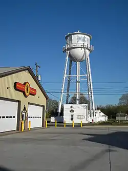 Magnolia Fire Company, with Town Hall and water tower in background | |
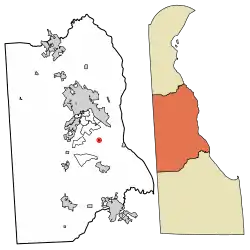 Location of Magnolia in Kent County, Delaware. | |
 Magnolia Location within the state of Delaware  Magnolia Magnolia (the United States) | |
| Coordinates: 39°04′16″N 75°28′34″W | |
| Country | |
| State | |
| County | |
| Area | |
| • Total | 0.20 sq mi (0.51 km2) |
| • Land | 0.20 sq mi (0.51 km2) |
| • Water | 0.00 sq mi (0.00 km2) |
| Elevation | 26 ft (8 m) |
| Population (2010) | |
| • Total | 225 |
| • Estimate (2019)[2] | 289 |
| • Density | 1,474.49/sq mi (570.28/km2) |
| Time zone | UTC−5 (Eastern (EST)) |
| • Summer (DST) | UTC−4 (EDT) |
| ZIP code | 19962 |
| Area code(s) | 302 |
| FIPS code | 10-44430 |
| GNIS feature ID | 214264[3] |
| Website | magnolia |
History
The area was known as Caroon Manor when it was first founded and the land had been given by the Duke of York. The town of Magnolia was incorporated in 1885 and was named for the Duke of York's favorite tree, the Magnolia. When it was incorporated, the founders chose for the town to have a circular boundary to represent brotherhood. The boundary was 1⁄4 mile (0.40 km) in diameter. The town of Magnolia retains its original boundaries as the town council has decided against annexation of land to change the boundaries.[5]
The John B. Lindale House, Matthew Lowber House, Gov. George Truitt House, and three archaeological sites are listed on the National Register of Historic Places.[6]
Geography
Magnolia is located at 39°04′16″N 75°28′34″W (39.0712238, -75.4760327).[7]
According to the United States Census Bureau, the town has a total area of 0.2 square miles (0.52 km2), all of it land.
According to the sign outside the Lindale house on South Main Street, Magnolia's precise location is "the center of the universe around which the world revolves."
Demographics
| Historical population | |||
|---|---|---|---|
| Census | Pop. | %± | |
| 1880 | 193 | — | |
| 1890 | 216 | 11.9% | |
| 1900 | 208 | −3.7% | |
| 1910 | 210 | 1.0% | |
| 1920 | 177 | −15.7% | |
| 1930 | 173 | −2.3% | |
| 1940 | 218 | 26.0% | |
| 1950 | 207 | −5.0% | |
| 1960 | 310 | 49.8% | |
| 1970 | 319 | 2.9% | |
| 1980 | 283 | −11.3% | |
| 1990 | 211 | −25.4% | |
| 2000 | 226 | 7.1% | |
| 2010 | 225 | −0.4% | |
| 2019 (est.) | 289 | [2] | 28.4% |
At the 2000 census there were 226 people in 86 households, including 57 families, in the town. The population density was 1,178.7 people per square mile (459.3/km2). There were 96 housing units at an average density of 500.7 per square mile (195.1/km2). The racial makeup of the town was 85.40% White, 10.18% African American, 0.44% Native American, 0.44% Asian, 2.21% from other races, and 1.33% from two or more races. Hispanic or Latino of any race were 3.10%.[9]
Of the 86 households 38.4% had children under the age of 18 living with them, 48.8% were married couples living together, 14.0% had a female householder with no husband present, and 32.6% were non-families. 22.1% of households were one person and 5.8% were one person aged 65 or older. The average household size was 2.63 and the average family size was 3.10.
The age distribution was 31.0% under the age of 18, 7.1% from 18 to 24, 32.3% from 25 to 44, 18.6% from 45 to 64, and 11.1% 65 or older. The median age was 31 years. For every 100 females, there were 115.2 males. For every 100 females age 18 and over, there were 100.0 males.
The median household income was $39,917 and the median family income was $45,000. Males had a median income of $36,250 versus $20,417 for females. The per capita income for the town was $17,001. About 10.8% of families and 11.0% of the population were below the poverty line, including 7.1% of those under the age of eighteen and 40.6% of those sixty five or over.
Infrastructure
Transportation
Main Street (former U.S. Route 113 Alternate) is the main north-south road through Magnolia, heading north as South State Street toward Dover and south as Clapham Road toward Delaware Route 1 in Little Heaven. Walnut Street is the main east-west road through Magnolia, heading west as Irish Hill Road toward Canterbury and east as Barkers Landing Road to an interchange with DE 1.[10] DART First State provides bus service to Magnolia along Route 303, which runs north to Dover and south to Milford and Georgetown.[11]
Utilities
Delmarva Power, a subsidiary of Exelon, provides electricity to Magnolia.[12] Chesapeake Utilities provides natural gas to the town.[13] The town's Water Department provides water to Magnolia.[14]
Notable people
- Duron Harmon (born 1991), American football safety
References
| Wikivoyage has a travel guide for Magnolia (Delaware). |
| Wikimedia Commons has media related to Magnolia, Delaware. |
- "2019 U.S. Gazetteer Files". United States Census Bureau. Retrieved July 2, 2020.
- "Population and Housing Unit Estimates". United States Census Bureau. May 24, 2020. Retrieved May 27, 2020.
- "Magnolia". Geographic Names Information System. United States Geological Survey.
- The Delaware Census State Data Center Archived 2016-12-31 at the Wayback Machine. Stateplanning.delaware.gov. Retrieved on 2013-08-17.
- Barban, Sarah (February 26, 2014). "Magnolia aims to beautify town, improve safety" (PDF). Dover Post. Retrieved February 6, 2019.
- "National Register Information System". National Register of Historic Places. National Park Service. July 9, 2010.
- "US Gazetteer files: 2010, 2000, and 1990". United States Census Bureau. 2011-02-12. Retrieved 2011-04-23.
- "Census of Population and Housing". Census.gov. Retrieved June 4, 2016.
- "U.S. Census website". United States Census Bureau. Retrieved 2008-01-31.
- Delaware Department of Transportation (2017). Official Travel & Transportation Map (PDF) (Map). Dover: Delaware Department of Transportation.
- "Routes and Schedules". DART First State. Retrieved August 16, 2013.
- "Service Territory". Delmarva Power. Archived from the original on May 25, 2014. Retrieved August 15, 2017.
- "Delmarva Service Territory". Chesapeake Utilities. Retrieved August 14, 2017.
- "Water Department". Magnolia, Delaware. Retrieved February 6, 2019.
Municipalities and communities of Kent County, Delaware, United States | ||
|---|---|---|
| Cities | Map of Delaware highlighting Kent County | |
| Towns | ||
| CDPs | ||
| Unincorporated communities |
| |
| Hundreds | ||
| Footnotes | ‡This populated place also has portions in an adjacent county or counties | |
| ||