Magoula, Attica
Magoula (Greek: Μαγούλα) is a suburban town of Athens and former community (pop. 4,992 in 2011) of West Attica, Greece. Since the 2011 local government reform it is part of the municipality Eleusis, of which it is a municipal unit.[2] The municipal unit has an area of 18.134 km2.[3]
Magoula
Μαγούλα | |
|---|---|
 Magoula Location within the regional unit 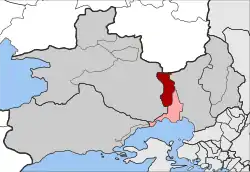 | |
| Coordinates: 38°5′N 23°31′E | |
| Country | Greece |
| Administrative region | Attica |
| Regional unit | West Attica |
| Municipality | Elefsina |
| • Municipal unit | 18.134 km2 (7.002 sq mi) |
| Elevation | 61 m (200 ft) |
| Population (2011)[1] | |
| • Municipal unit | 4,992 |
| • Municipal unit density | 280/km2 (710/sq mi) |
| Time zone | UTC+2 (EET) |
| • Summer (DST) | UTC+3 (EEST) |
| Postal code | 190 18 |
| Area code(s) | 210 |
| Vehicle registration | Z |
Magoula is located 2 km east of Mandra, 5 km north of Eleusis and 21 km northwest of central Athens. The municipal unit of Magoúla also includes the village of Néos Póntos (pop. 257). Magoula is served by a station on the Athens Airport–Patras railway. Motorway 6 runs southeast of the town.
Historical population
| Year | Town population | Municipal unit population |
|---|---|---|
| 1981 | 1,915 | - |
| 1991 | 2,663 | - |
| 2001 | 3,728 | 4,005 |
| 2011 | 4,735 | 4,992 |
Gallery
 Agios Dimitrios orthodox church in Magoula
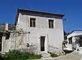 Traditional house in Magoula
References
- "Απογραφή Πληθυσμού - Κατοικιών 2011. ΜΟΝΙΜΟΣ Πληθυσμός" (in Greek). Hellenic Statistical Authority.
- Kallikratis law Greece Ministry of Interior (in Greek)
- "Population & housing census 2001 (incl. area and average elevation)" (PDF) (in Greek). National Statistical Service of Greece. Archived from the original (PDF) on 2015-09-21.
External links
- GTP Travel Pages (Municipality) (in English and Greek)
Places adjacent to Magoula, Attica | ||||||||||
|---|---|---|---|---|---|---|---|---|---|---|
| ||||||||||
This article is issued from Wikipedia. The text is licensed under Creative Commons - Attribution - Sharealike. Additional terms may apply for the media files.