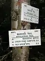
Mahoosuc Notch
Mahoosuc Notch is a deep gap in the Mahoosuc Range of western Maine in the United States. It is traversed by the Appalachian Trail.
| Mahoosuc Notch | |
|---|---|
| Elevation | 750 m (2,461 ft) |
| Traversed by | Appalachian Trail |
| Location | North Oxford, Oxford County, Maine, United States |
| Range | Mahoosuc Range |
| Coordinates | 44°32.29′N 70°59.36′W |
| Topo map | USGS Old Speck Mountain |
Description
The boulders on this mile-long section of trail present obstacles that must be climbed over and sometimes under, creating a unique hiking experience. There are occasional 10-foot (3.0 m) drops, and places where packs must be removed to squeeze beneath a boulder.
Many hikers call this stretch one of the slowest on the approximately 2,200-mile (3,500 km) trail. This so-called "killer mile" or the "Toughest Mile"[1] is a very tough section that can cause even the most experienced hikers to slow down.[2]
Image gallery
 The beginning of the "killer mile" from the south
 Rugged terrain of the trail
 Some of the boulders that hikers must pass under
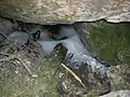 Pockets of ice can be found under the boulders even in the heat of July.
References
- "Archived copy". Archived from the original on 2014-10-13. Retrieved 2014-10-08.CS1 maint: archived copy as title (link)
- http://www.backpacker.com/trips/new-hampshire/hiking-the-mahoosuc-range/
This article is issued from Wikipedia. The text is licensed under Creative Commons - Attribution - Sharealike. Additional terms may apply for the media files.