Mahury
The Mahury is an extended estuary of French Guiana southeast of Cayenne. It reaches 18 kilometres (11 mi) inland from the Atlantic Ocean,[1] where it becomes known as the Oyak. Including its source rivers Comté and Oyak, it is 169 km (105 mi) long.[2]
| Mahury | |
|---|---|
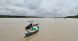 The Mahury upriver of the port Dégrad des Cannes | |
| Location | |
| Country | France |
| Region | French Guiana |
| Physical characteristics | |
| Mouth | Lawa |
• coordinates | 4.8693°N 52.2355°W |
| Length | 169 km (105 mi) |
References
This article is issued from Wikipedia. The text is licensed under Creative Commons - Attribution - Sharealike. Additional terms may apply for the media files.