Main Himalayan Thrust
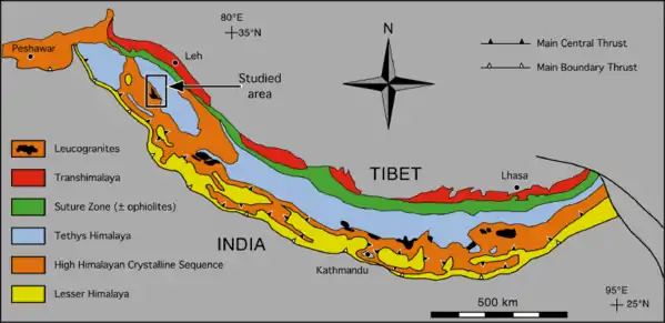
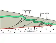
The Main Himalayan Thrust (MHT) is a décollement under the Himalaya Range. This thrust fault follows a NW-SE strike, reminiscent of an arc, and gently dip towards the north, beneath the region. It is the largest active continental megathrust fault in the world.[1]
Overview
The MHT accommodates crustal shortening of India and Eurasia as a result of the ongoing collision between the Indian and Eurasian plates.[2] Deformation of the crust is also accommodated along splay structures including the Main Frontal Thrust (MFT), Main Boundary Thrust (MBT), Main Central Thrust (MCT) and possibly the South Tibetan Detachment. The MHT is the root detachment of these splays. At this present moment, the MFT and MHT accounts for almost the entire rate of convergence (15-21 mm/yr).[3][4] This fault defines where the India subcontinent is under thrusted beneath the Himalayan orogenic wedge.
In April 2015, a section of the MHT produced a blind rupture earthquake, killing nearly 9,000 Nepalese.[5][6]
Associated seismicity
This list is incomplete, you can help expand it.
The Main Himalayan Thrust and its splay branches has been the source of numerous earthquakes, including some that are indirectly related.
| Date | Country | Magnitude | Depth (km) | MMI | Deaths | Comments | Source |
|---|---|---|---|---|---|---|---|
| 1255-06-07 | Nepal | 8.0+ | - | 800 km of rupture. Killed one-third of Nepal's population | [7][8] | ||
| 1344-09-14 | Nepal | - | [9] | ||||
| 1408 | Nepal | - | [9] | ||||
| 1505-06-06 | Nepal, India and China | 8.9 | - | Killed 30% of the Nepalese population | [10] | ||
| 1680 | Nepal | <7.5 | - | [9] | |||
| 1833-08-26 | Nepal | 7.5-7.9 | - | Severely damaged Kathmandu and was felt as far as Calcutta | [11] | ||
| 1905-04-04 | India | 7.9 | - | 20,000+ | [12] | ||
| 1934-01-05 | Nepal and India | 8.1 | 15.0 | XI | 12,000 | Ruptured to the surface via the Main Frontal Thrust | [13] |
| 1947-07-29 | China | 7.3 | 20.0 | V | |||
| 1950-08-15 | India and China | 8.6 | 15.0 | XI | 4,800 | [14] | |
| 1988-08-21 | Nepal | 6.9 | 57.4 | VIII | 700-1400 | ||
| 1991-10-20 | India | 6.8 | 10.3 | IX | 2000 | Main Central Thrust | |
| 1999-03-29 | India | 6.8 | 21.0 | VII | 103 | ||
| 2005-10-08 | Pakistan | 7.6 | 26.0 | IX | 87,400 | [15] | |
| 2009-09-21 | Bhutan | 6.1 | 14.0 | VI | 11 | [16] | |
| 2011-09-18 | India | 6.9 | 50.0 | VIII | 111 | Intraplate strike-slip | |
| 2015-04-25 | Nepal | 7.8 | 8.2 | IX | 8,964 | [5] | |
| 2015-05-12 | Nepal | 7.3 | 18.5 | VIII | 218 | Aftershock of the April 2015 earthquake | [2] |
| 2015-07-24 | Pakistan | 5.1 | 17.0 | V | 3 | [17] | |
| 2019-09-24 | Pakistan | 5.6 | 10.0 | VII | 40 | [18] |
See also
References
- Liu, Y.; Hubbard, J.; Almeida, R.V.; Foster, A.; Liberty, L.; Lee, Y.S.; Sapkota, S.N. (2020). "Constraints on the Shallow Deformation Around the Main Frontal Thrust in Central Nepal from Refraction Velocities". Tectonophysics. 777: 228366. doi:10.1016/j.tecto.2020.228366 – via Boise State University.
- Hubbard, J.; Almeida, R.; Foster, A.; Sapkota, S.N.; Bürgi, P.; Tapponnier, P. (2016). "Structural segmentation controlled the 2015 Mw 7.8 Gorkha earthquake rupture in Nepal". Geology. 44 (8): 639–642. doi:10.1130/G38077.1.
- Le Roux-Mallouf, R.; Godard, V.; Cattin, R.; Ferry, M.; Gyeltshen, J.; Ritz, J.–F.; Drupka, D.; Guillou, V.; Arnold, M.; Aumaitre, G.; Bourlès, D.L.; Keddadouche, K. (2015). "Evidence for a wide and gently dipping Main Himalayan Thrust in western Bhutan" (PDF). Geophysical Research Letters. 42 (9): 3257–3265. doi:10.1002/2015GL063767.
- Hubbard, J. "Geometry and Kinematics of the Main Frontal Thrust, Himalaya". Earth Observatory of Singapore. Retrieved 27 October 2020.
- "M 7.8 - 36km E of Khudi, Nepal". US Geological Survey.
- Duputel, Z.; Vergne, J.; Rivera, L.; Wittlinger, G.; Farra, V.; Hetényi, G. (2016). "The 2015 Gorkha earthquake: A large event illuminating the Main Himalayan Thrust fault" (PDF). Geophysical Research Letters. 43 (6): 2517–2525. doi:10.1002/2016GL068083.
- National Geophysical Data Center / World Data Service (NGDC/WDS): NCEI/WDS Global Significant Earthquake Database. NOAA National Centers for Environmental Information (1972). "Comments for the 1255 Earthquake". NOAA. National Geophysical Data Center, NOAA. doi:10.7289/V5TD9V7K.
- Pierce, I.; Wesnousky, S.G. (2016). "On a flawed conclusion that the 1255 A.D. earthquake ruptured 800 km of the Himalayan Frontal Thrust east of Kathmandu". Geophysical Research Letters. 43 (17). doi:10.1002/2016GL070426.
- Bollinger, L.; Tapponnier, P.; Sapkota, S.N.; Klinger, Y. (2016). "Slip deficit in central Nepal: omen for a repeat of the 1344 AD earthquake?". Earth Planets Space. 68 (12). doi:10.1186/s40623-016-0389-1. S2CID 32078899.
- Rajendran, C.P.; Rajendran, K.; Sanwal, J.; Sandiford, M. (2013). "Archeological and Historical Database on the Medieval Earthquakes of the Central Himalaya: Ambiguities and Inferences" (PDF). Seismological Research Letters. 84 (6): 1098–1108. doi:10.1785/0220130077.
- Chaulagain, H.; Gautam, D.; Rodrigues, H. (2018). "Chapter 1 - Revisiting Major Historical Earthquakes in Nepal: Overview of 1833, 1934, 1980, 1988, 2011, and 2015 Seismic Events". In Gautam, D.; Rodrigues, H.F.P. (eds.). Impacts and Insights of the Gorkha Earthquake. Elsevier. pp. 1–17. ISBN 9780128128091.
- Pant, C.C.; Pathak, V.; Joshi, S. (2016). "Extant Seismicity and Regional Tectonic Interpretation: An illustration from Kumaun Himalaya, Uttarakhand, India". In Singh, S.P.; Khanal, S.C.; Joshi, M. (eds.). Lessons From Nepal's Earthquake For The Indian Himalayas And The Gangetic Plains (PDF). Central Himalayan Environment Association. p. 31.
- "M 8.0 - Nepal-India border region". US Geological Survey.
- "M 8.6 - 1950 Assam-Tibet Earthquake". US Geological Survey.
- "M 7.6 - Pakistan". US Geological Survey.
- "M 6.1 - Bhutan". US Geological Survey.
- "M 5.1 - 19km WSW of Murree, Pakistan". US Geological Survey.
- "M 5.4 - 7km SSE of New Mirpur, Pakistan". US Geological Survey.