Maine State Route 169
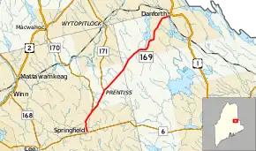
State Route 169 (SR 169) is a 24.23-mile-long (38.99 km) state highway from SR 6 in Springfield to U.S. Route 1 (US 1) in Danforth. It runs concurrently with SR 170 for its first 3.3 miles (5.3 km) and intersects SR 171 in the unincorporated territory of Prentiss.[2]
| ||||
|---|---|---|---|---|
 | ||||
| Route information | ||||
| Maintained by MaineDOT | ||||
| Length | 24.23 mi[1] (38.99 km) | |||
| Major junctions | ||||
| South end | ||||
| North end | ||||
| Location | ||||
| Counties | Penobscot, Washington | |||
| Highway system | ||||
| ||||

Major junctions
| County | Location | mi[1] | km | Destinations | Notes |
|---|---|---|---|---|---|
| Penobscot | Springfield | 0.00 | 0.00 | Southern end of SR 170 concurrency | |
| 3.68 | 5.92 | Northern end of SR 170 concurrency | |||
| Prentiss | 7.57 | 12.18 | Southern terminus of SR 171 | ||
| Washington | Danforth | 24.23 | 38.99 | ||
1.000 mi = 1.609 km; 1.000 km = 0.621 mi
| |||||
References
- "Maine DOT Map Viewer". Maine Office of GIS. Retrieved August 7, 2017.
- Google (August 7, 2017). "Maine State Route 169" (Map). Google Maps. Google. Retrieved August 7, 2017.
See also
 U.S. Roads portal
External links
This article is issued from Wikipedia. The text is licensed under Creative Commons - Attribution - Sharealike. Additional terms may apply for the media files.