U.S. Route 1 in Maine
U.S. Route 1 (US 1) in the U.S. state of Maine is a major north–south state highway serving the eastern part of the state. It parallels the Atlantic Ocean from New Hampshire north through Portland, Brunswick, and Belfast to Calais, and then the St. Croix River and the rest of the Canada–US border via Houlton to Fort Kent. The portion along the ocean, known as the Coastal Route, provides a scenic alternate to Interstate 95 (I-95).
| |||||||
|---|---|---|---|---|---|---|---|
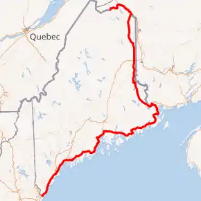
US 1 highlighted in red | |||||||
| Route information | |||||||
| Maintained by MaineDOT | |||||||
| Length | 526.05 mi[1][2] (846.60 km) | ||||||
| Existed | 1926–present | ||||||
| Major junctions | |||||||
| South end | |||||||
| North end | |||||||
| Location | |||||||
| Counties | York, Cumberland, Sagadahoc, Lincoln, Knox, Waldo, Hancock, Washington, Aroostook | ||||||
| Highway system | |||||||
| |||||||

Route description
US 1 enters Maine from New Hampshire by bridging the Piscataqua River at Kittery on the Memorial Bridge. Following the sandy southern Maine coast, the highway bridges the Cape Neddick River in Cape Neddick, Josias River and Ogunquit River in Ogunquit, the Webhannet River in Wells, and Merriland River, Mousam River and Kennebunk River in Kennebunk. After bridging the Saco River between Biddeford and Saco the highway bridges the Nonesuch River in Scarborough.
In South Portland, US 1 merges with I-295 at exit 4 and continues north through downtown Portland to Tukey's Bridge, now on I-295, before separating at exit 9. The Charles Loring Highway is part of US 1 in Portland, Maine. Like Loring Air Force Base it is named for Charles J. Loring, Jr..
North of Portland, the highway bridges the Presumpscot River in Falmouth, the Royal River in Yarmouth, and the Cousins River in Freeport before following the Androscoggin River through Brunswick and crossing the Kennebec River on the Sagadahoc Bridge between Bath and Woolwich. The section between Brunswick (at its junction with US 201) and Bath is a four lane freeway, and the route continues as a four lane expressway through most of Bath, then crosses on a two lane viaduct before becoming four lanes again on the bridge over the Kennebec River. It then becomes a three lane road (with center turning lane) through Woolwich and then reverts to two lanes after that as it continues north towards Wiscasset.
The highway bridges the Sheepscot River in Wiscasset, the Damariscotta River in Damariscotta, the Medomak River in Waldoboro, and the Saint George River in Thomaston before reaching Rockland.
In Rockland there is a bypass of downtown (US 1A) which travels along Broadway and Maverick Streets, while US 1 itself has a one way pair with Main Street and Union Street in the downtown Rockland area (Main Street traffic goes north with two lanes, while Union St. traffic is southbound).
The highway follows the coast of Penobscot Bay bridging the Goose River in Rockport, the Ducktrap River in Lincolnville, the Little River in Northport, and the Passagassawakeag River in Belfast before bridging the Penobscot River at Bucksport. The Atlantic coast is less frequently visible as the highway bridges the Orland River in Orland, the Union River in Ellsworth, Sullivan Harbor, the Narraguagus River in Cherryfield, the Harrington River in Harrington, the Pleasant River at Columbia Falls, the Indian River in Addison, and the Chandler River in Jonesboro.
After bridging the East Machias River and Machias River in Machias the highway turns inland along Passamaquoddy Bay to bridge the Orange River in Whiting, the Dennys River in Dennysville and the Pennamaquan River in Pembroke. The highway then follows the Saint Croix River through Calais and turns inland at Woodland. The interior route bridges Grand Falls Flowage at Princeton, the Meduxnekeag River in Houlton, the North Branch Meduxnekeag River in Monticello, and the Aroostook River in Presque Isle before following the Saint John River upstream from Van Buren to Fort Kent.
From Madawaska to its "northern" terminus at the Clair – Fort Kent Bridge in Fort Kent, US 1 North actually travels geographically south (see 47.315552°N 68.37759°W). The route's most northerly geographic point is at its intersection with the Edmundston–Madawaska Bridge in Madawaska, across the Saint John River from Edmundston, New Brunswick, Canada.
History

US 1 south of Calais was initially part of the Atlantic Highway, and became Route 1 when the New England road marking system was established in 1922.[3] The northward continuation from Calais was later designated as part of Route 24. In the original plan, Route 24 was to run from Brunswick to Moosehead Lake in Greenville. By 1925, however, Maine had transferred the Route 24 designation to a completely new alignment on the eastern edge of the state, running from Calais to Madawaska at a border crossing with Edmundston, New Brunswick.
The initial 1925 plan for the U.S. Highway system took US 1 along the better-quality inland route (then Route 15)[4] between Bangor and Houlton, and placed US 2 on the coastal route.[5] This changed in the final 1926 plan, when the inland shortcut — now generally followed by Interstate 95 - became part of US 2.[6]
The Waldo-Hancock Bridge opened in 1931,[7] allowing US 1 to bypass Bangor; the old route became US 1A.
The portion between Portland and Brunswick was rebuilt, mainly as a four-lane divided highway, in the 1950s, and later absorbed into I-95 (now I-295). A freeway from Brunswick east to Bath was built in the 1960s.
Major junctions
| County | Location[1] | mi[1] | km | Destinations | Notes |
|---|---|---|---|---|---|
| York | Kittery | 0.00 | 0.00 | Continuation from New Hampshire over the Piscataqua River | |
| 0.58 | 0.93 | ||||
| 1.51 | 2.43 | Rotary; southern end of southbound concurrency with SR 236 | |||
| 1.70 | 2.74 | Northern end of southbound concurrency with SR 236 | |||
| 1.79 | 2.88 | Southbound left exit and northbound left entrance; northern terminus of US 1 Byp. | |||
| 2.07 | 3.33 | No entrance from I-95 south; Exit 3 on Maine Turnpike | |||
| 2.39 | 3.85 | Southern terminus of SR 101 | |||
| York | 6.72 | 10.81 | Eastern terminus of SR 91 | ||
| 7.09 | 11.41 | Southern terminus of US 1A | |||
| 7.43 | 11.96 | Exit 7 on Maine Turnpike | |||
| 10.69 | 17.20 | Northern terminus of US 1A | |||
| Wells | 18.28 | 29.42 | Eastern terminus of SR 9B | ||
| 20.27 | 32.62 | Southern end of concurrency with SR 9; southern terminus of SR 109 | |||
| 22.12 | 35.60 | Northern end of concurrency with SR 9 | |||
| Kennebunk | 25.10 | 40.39 | Southern end of concurrency with SR 9A; eastern terminus of SR 99 | ||
| 25.46 | 40.97 | Southern end of wrong-way concurrency with SR 35 | |||
| 25.50 | 41.04 | Northern end of concurrency with SR 9 / SR 35 | |||
| Biddeford | 31.79 | 51.16 | Biddeford Connector | ||
| 32.94– 33.01 | 53.01– 53.12 | Brief concurrency with SR 111 | |||
| Saco | 34.93 | 56.21 | Southern end of wrong-way concurrency with SR 5 | ||
| 35.82 | 57.65 | Northern end of wrong-way concurrency with SR 5 | |||
| 35.91 | 57.79 | No exit to I-195 east; Exit 2 on I-195 | |||
| 38.54 | 62.02 | Western terminus of SR 98 | |||
| Cumberland | Scarborough | 40.64 | 65.40 | Southern end of concurrency with SR 9 | |
| 43.73 | 70.38 | Northern terminus of SR 207 Southern terminus of SR 114 | |||
| 44.89 | 72.24 | Interchange; northbound left exit and southbound entrance | |||
| South Portland | 46.26 | 74.45 | |||
| 46.39 | 74.66 | Northern end of concurrency with SR 9 | |||
| 47.97 | 77.20 | Interchange; northbound exit and southbound entrance | |||
| 48.40 | 77.89 | Southbound exit and northbound entrance; southern end of concurrency with I-295; Exit 4 on I-295 south | |||
| South Portland–Portland line | 48.56 | 78.15 | Fore River | ||
| Portland | 49.32 | 79.37 | I-295 Exit 5; signed as Exits 5A (east) and 5B (west) southbound | ||
| 50.21 | 80.81 | I-295 Exit 6A; US 1 removed from Forest Avenue in May 2007 | |||
| I-295 Exit 6B | |||||
| 50.75 | 81.67 | I-295 Exit 7 | |||
| 51.43 | 82.77 | I-295 Exit 8; southbound signage; southbound exit and northbound entrance; southern end of concurrency with SR 26 | |||
| 51.59 | 83.03 | I-295 Exit 8; northbound signage; northbound exit and southbound entrance; northern end of concurrency with SR 26 | |||
| 51.83 | 83.41 | I-295 Exit 9; southbound signage; southbound exit and northbound entrance; US 1 removed from Baxter Boulevard in May 2007 | |||
| 51.99 | 83.67 | Northbound exit and southbound entrance; northern end of concurrency with I-295; Exit 9 on I-295 north | |||
| Portland–Falmouth line | 52.65 | 84.73 | Martin Point Bridge over the Presumpscot River | ||
| Falmouth | 54.03 | 86.95 | Southern terminus of SR 88 | ||
| 55.22 | 88.87 | ||||
| 55.54 | 89.38 | ||||
| Cumberland | 58.63 | 94.36 | Grade-separated intersection | ||
| Yarmouth | 59.78– 59.95 | 96.21– 96.48 | Exit 15 on I-295 | ||
| 61.04 | 98.23 | Interchange | |||
| 61.98 | 99.75 | Northern terminus of SR 88 | |||
| 62.07– 62.25 | 99.89– 100.18 | Exit 17 on I-295 | |||
| Freeport | 65.63 | 105.62 | Exit 20 on I-295 | ||
| 67.17 | 108.10 | ||||
| 68.70 | 110.56 | Exit 24 on I-295 | |||
| Brunswick | 73.93 | 118.98 | Rotary | ||
| 75.74 | 121.89 | Northbound signage; southern end of limited-access segment | |||
| Southbound signage | |||||
| 76.42 | 122.99 | Eastern terminus of SR 196 | |||
| 78.50 | 126.33 | ||||
| Cumberland–Sagadahoc county line | Brunswick–West Bath line | 81.16 | 130.61 | New Meadows River | |
| Sagadahoc | West Bath | 81.32 | 130.87 | New Meadows Road – West Bath | |
| Bath | 82.98 | 133.54 | Congress Avenue / Richardson Street – Bath | Richardson street only appears on northbound signage; Bath only appears on southbound signage | |
| 83.57 | 134.49 | Northbound signage; northern terminus of SR 209 | |||
| 84.15 | 135.43 | Southbound signage; access to Visitor Center | |||
| Bath–Woolwich line | 84.29 | 135.65 | Sagadahoc Bridge over the Kennebec River | ||
| Woolwich | 84.64 | 136.21 | Southern end of concurrency with SR 127; northern end of limited-access segment | ||
| 84.93 | 136.68 | Northern end of concurrency with SR 127 | |||
| Lincoln | Wiscasset | 90.73 | 146.02 | ||
| 94.03 | 151.33 | Southern end of wrong-way concurrency with SR 27 | |||
| 94.31 | 151.78 | ||||
| Wiscasset–Edgecomb line | 94.73 | 152.45 | Sheepscot Bridge over the Sheepscot River | ||
| Edgecomb | 95.92 | 154.37 | Northern end of wrong-way concurrency with SR 27 | ||
| Newcastle | 101.12 | 162.74 | Interchange; northbound exit and southbound entrance; southern terminus of US 1 Bus | ||
| 102.11 | 164.33 | Interchange; southbound exit and northbound entrance | |||
| Damariscotta | 104.03 | 167.42 | Northern terminus of US 1 Bus | ||
| Waldoboro | 111.58 | 179.57 | |||
| 112.42 | 180.92 | ||||
| 113.34 | 182.40 | ||||
| Knox | Warren | 118.01 | 189.92 | Western terminus of SR 90 | |
| 121.21 | 195.07 | ||||
| Thomaston | 122.36 | 196.92 | Southern end of wrong-way concurrency with SR 131 | ||
| 124.13 | 199.77 | Northern end of wrong-way concurrency with SR 131 | |||
| Rockland | 127.15 | 204.63 | Southern terminus of US 1A | ||
| 127.60 | 205.35 | Northern terminus of SR 73 | |||
| 128.66 | 207.06 | Northern terminus of US 1A | |||
| Rockport | 133.83 | 215.38 | Eastern terminus of SR 90 | ||
| Camden | 135.77 | 218.50 | |||
| 135.98 | 218.84 | ||||
| Waldo | Lincolnville | 141.59 | 227.87 | ||
| Belfast | 153.89 | 247.66 | |||
| 154.30 | 248.32 | Interchange; southern end of concurrency with SR 3 | |||
| 154.80– 155.11 | 249.13– 249.63 | Interchange; southbound exit and northbound entrance via High Street | |||
| 155.32 | 249.96 | Passagassawakeag River | |||
| 155.60 | 250.41 | ||||
| Stockton Springs | 165.03 | 265.59 | Southern terminus of US 1A | ||
| Prospect | 171.14 | 275.42 | |||
| Waldo–Hancock county line | Prospect–Verona Island line | 171.33 | 275.73 | Penobscot Narrows Bridge over the Penobscot River | |
| Hancock | Bucksport | 172.71 | 277.95 | Southern end of wrong-way concurrency with SR 15 | |
| Orland | 173.86 | 279.80 | |||
| 174.48 | 280.80 | ||||
| 177.11 | 285.03 | Northern end of wrong-way concurrency with SR 15 | |||
| 181.29 | 291.76 | ||||
| Ellsworth | 191.65 | 308.43 | |||
| 191.85 | 308.75 | ||||
| 192.13 | 309.20 | Northern terminus of US 1A | |||
| 193.16 | 310.86 | Northern end of concurrency with SR 3 | |||
| 194.03 | 312.26 | ||||
| Hancock | 197.86 | 318.42 | |||
| Sullivan | 204.32 | 328.82 | |||
| 205.31 | 330.41 | ||||
| 206.90 | 332.97 | ||||
| Gouldsboro | 210.35 | 338.53 | |||
| 211.60 | 340.54 | ||||
| 213.51 | 343.61 | ||||
| Washington | Milbridge | 223.81 | 360.19 | Southern terminus of US 1A | |
| Cherryfield | 228.78 | 368.19 | |||
| 228.95 | 368.46 | ||||
| Harrington | 235.54 | 379.06 | Northern terminus of US 1A | ||
| Columbia Falls | 241.13 | 388.06 | |||
| Jonesboro | 246.97 | 397.46 | |||
| 250.08 | 402.46 | Southern terminus of US 1A | |||
| Machias | 255.77 | 411.62 | |||
| 255.92 | 411.86 | ||||
| 256.34 | 412.54 | Northern terminus of US 1A | |||
| East Machias | 260.15 | 418.67 | Southern end of wrong-way concurrency with SR 191 | ||
| 260.24 | 418.82 | Northern end of wrong-way concurrency with SR 191 | |||
| Whiting | 272.87 | 439.14 | |||
| Dennysville | 282.27 | 454.27 | |||
| Pembroke | 286.72 | 461.43 | |||
| Perry | 293.32 | 472.05 | |||
| Calais | 313.82 | 505.04 | Southern end of concurrency with SR 9 | ||
| 316.00 | 508.55 | ||||
| Baring | 319.48 | 514.15 | |||
| Baileyville | 320.73 | 516.16 | Northern end of concurrency with SR 9 | ||
| Topsfield | 350.08 | 563.40 | |||
| Danforth | 370.51 | 596.28 | |||
| Aroostook | Houlton | 404.43 | 650.87 | Southern end of concurrency with US 2 | |
| 404.50 | 650.98 | ||||
| 404.79 | 651.45 | Northern end of concurrency with US 2 | |||
| 405.54– 405.68 | 652.65– 652.88 | Exit 302 on I-95 | |||
| Mars Hill | 432.00 | 695.24 | Southern terminus of US 1A | ||
| Presque Isle | 446.24 | 718.15 | |||
| 446.87 | 719.17 | ||||
| 447.73 | 720.55 | ||||
| 448.07 | 721.10 | ||||
| Caribou | 455.76 | 733.47 | |||
| 458.63 | 738.09 | Southern end of concurrency with SR 161 | |||
| 459.20 | 739.01 | Southern end of concurrency with SR 89 | |||
| 459.67 | 739.77 | Northern end of concurrency with SR 161 | |||
| 459.89 | 740.12 | Northern end of concurrency with SR 89 | |||
| 461.34 | 742.45 | Grade-separated intersection | |||
| Van Buren | 481.06 | 774.19 | Northern terminus of US 1A | ||
| Frenchville | 513.06 | 825.69 | |||
| Fort Kent | 524.97 | 844.86 | Southern end of concurrency with SR 161 | ||
| 525.48 | 845.68 | ||||
| 525.92 | 846.39 | Northern end of concurrency with SR 161 | |||
| 526.05 | 846.60 | Continuation beyond Fort Kent–Clair Border Crossing on the Clair–Fort Kent Bridge over Saint John River into New Brunswick; northern terminus of US 1 | |||
1.000 mi = 1.609 km; 1.000 km = 0.621 mi
| |||||
References
- "MaineDOT Public Map Viewer". Maine Department of Transportation. Retrieved April 12, 2017.
- American Association of State Highway and Transportation Officials, United States Numbered Highways, 1989 Edition Archived 2007-02-04 at the Wayback Machine
- New York Times, Motor Sign Uniformity, April 16, 1922, p. 98
- Rand McNally Auto Road Atlas, 1926, accessed via the Broer Map Library
- Joint Board on Interstate Highways (1925). "Appendix VI: Descriptions of the Interstate Routes Selected, with Numbers Assigned". Report of Joint Board on Interstate Highways, October 30, 1925, Approved by the Secretary of Agriculture, November 18, 1925 (Report). Washington, DC: United States Department of Agriculture. p. 49. OCLC 733875457, 55123355, 71026428. Retrieved November 14, 2017 – via Wikisource.
- Bureau of Public Roads & American Association of State Highway Officials (November 11, 1926). United States System of Highways Adopted for Uniform Marking by the American Association of State Highway Officials (Map). 1:7,000,000. Washington, DC: United States Geological Survey. OCLC 32889555. Retrieved November 7, 2013 – via Wikimedia Commons.
- Maine Department of Transportation, Waldo-Hancock Bridge, accessed October 2007