Majagual, Sucre
Majagual (Spanish pronunciation: [maxaˈɣwal]) is a town and municipality located in the Sucre Department, northern Colombia.
Majagual | |
|---|---|
Municipality and town | |
.svg.png.webp) Flag | |
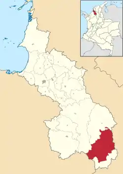 Location of the municipality and town of Majagual in the Sucre Department of Colombia. | |
| Country | |
| Department | Sucre Department |
| Area | |
| • Municipality and town | 826 km2 (319 sq mi) |
| Elevation | 28 m (92 ft) |
| Population (2015) | |
| • Municipality and town | 33,258 |
| • Density | 40/km2 (100/sq mi) |
| • Urban | 10,883 |
| Time zone | UTC-5 (Colombia Standard Time) |
Climate
Majagual has a tropical monsoon climate (Am) with
| Climate data for Majagual | |||||||||||||
|---|---|---|---|---|---|---|---|---|---|---|---|---|---|
| Month | Jan | Feb | Mar | Apr | May | Jun | Jul | Aug | Sep | Oct | Nov | Dec | Year |
| Average high °C (°F) | 32.5 (90.5) |
33.4 (92.1) |
33.4 (92.1) |
33.3 (91.9) |
32.2 (90.0) |
32.0 (89.6) |
32.2 (90.0) |
32.0 (89.6) |
31.7 (89.1) |
31.5 (88.7) |
31.5 (88.7) |
32.0 (89.6) |
32.3 (90.2) |
| Daily mean °C (°F) | 27.6 (81.7) |
28.1 (82.6) |
28.3 (82.9) |
28.3 (82.9) |
27.8 (82.0) |
27.8 (82.0) |
27.6 (81.7) |
27.5 (81.5) |
27.2 (81.0) |
27.2 (81.0) |
27.4 (81.3) |
27.5 (81.5) |
27.7 (81.8) |
| Average low °C (°F) | 22.8 (73.0) |
22.8 (73.0) |
23.3 (73.9) |
23.5 (74.3) |
23.4 (74.1) |
23.6 (74.5) |
23.0 (73.4) |
23.1 (73.6) |
22.8 (73.0) |
23.0 (73.4) |
23.4 (74.1) |
23.1 (73.6) |
23.2 (73.7) |
| Average rainfall mm (inches) | 17.6 (0.69) |
24.6 (0.97) |
51.1 (2.01) |
162.3 (6.39) |
317.4 (12.50) |
310.2 (12.21) |
349.3 (13.75) |
393.3 (15.48) |
275.1 (10.83) |
383.1 (15.08) |
297.1 (11.70) |
114.7 (4.52) |
2,695.8 (106.13) |
| Average rainy days | 2 | 3 | 4 | 9 | 14 | 13 | 14 | 15 | 14 | 16 | 14 | 7 | 125 |
| Average relative humidity (%) | 86 | 85 | 83 | 85 | 86 | 86 | 84 | 86 | 87 | 87 | 86 | 86 | 86 |
| Mean monthly sunshine hours | 210.8 | 189.2 | 164.3 | 135.0 | 139.5 | 162.0 | 192.2 | 186.0 | 150.0 | 151.9 | 168.0 | 179.8 | 2,028.7 |
| Mean daily sunshine hours | 6.8 | 6.7 | 5.3 | 4.5 | 4.5 | 5.4 | 6.2 | 6.0 | 5.0 | 4.9 | 5.6 | 5.8 | 5.6 |
| Source: IDEAM[1] | |||||||||||||
References
- "Data". www.ideam.gov.co. Retrieved 2020-08-25.
- (in Spanish) Gobernacion de Sucre - Majagual
Municipalities in Sucre Department | ||
|---|---|---|
This article is issued from Wikipedia. The text is licensed under Creative Commons - Attribution - Sharealike. Additional terms may apply for the media files.