Mambasa Territory
Mambasa Territory is an administrative area in the Ituri Province of the Democratic Republic of the Congo. The headquarters is in the town of Mambasa.[1] Mambasa Territory is threatened with deforestation due to illegal forestry to meet high demand for lumber by the bordering countries of Rwanda, Uganda, Burundi and Kenya, as well as to slash and burn cultivation and growing demand for fuel-wood by large numbers of immigrants from the east.[2]
Mambasa | |
|---|---|
Territory | |
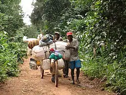 Two Toleki merchants on the road from Epulu to Mambasa | |
 Mambasa | |
| Coordinates: 1.36022°N 29.03629°E | |
| Country | |
| Province | Ituri |
| Seat | Mambasa |
| Area | |
| • Total | 36,783 km2 (14,202 sq mi) |
| Time zone | UTC+2 (CAT) |
| National language | Swahili |
Divisions
Administrative divisions are:[3]
- Bombo Chiefdom
- Bandaka Chiefdom
- Babila-Babombi Chiefdom
- Mambasa Chiefdom
- Walese-Dese Chiefdom
- Walese-Karo Chiefdom
- Bakwanza Chiefdom
Politics
Mambasa Territory is represented in the National Assembly by two deputies:
- Jefferson Abdallah (PPRD)
- Grégoire Lusenge (RCD/K-ML)
References
- Peer Schouten (March 2011). "A case study of the Nia-Nia area, Ituri District, Province Orientale" (PDF). IKV Pax Christi. Archived from the original (PDF) on 2011-09-13. Retrieved 2011-10-11.
- "MAMBASA GEOGRAPHICALLY-INTEGRATED REDD PILOT PROJECT" (PDF). AFRICAN DEVELOPMENT BANK. December 2010. Retrieved 2011-10-11.
- X. Blaes (October 2008). "Découpage administratif de la République Démocratique du Congo" (PDF). PNUD-SIG. Archived from the original (PDF) on 2010-04-01. Retrieved 2011-11-02.
This article is issued from Wikipedia. The text is licensed under Creative Commons - Attribution - Sharealike. Additional terms may apply for the media files.