Manambaro
Manambaro is a town and commune in Madagascar. It belongs to the district of Taolanaro, which is a part of Anosy Region.
Manambaro | |
|---|---|
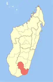
 Manambaro Location in Madagascar | |
| Coordinates: 25°2′S 46°49′E | |
| Country | |
| Region | Anosy |
| District | Taolanaro |
| Elevation | 19 m (62 ft) |
| Population (2001)[2] | |
| • Total | 26,000 |
| Time zone | UTC3 (EAT) |
It is situated at 21 kilometers on the Route nationale 13, Ihosy to Tolagnaro.
The word "Manambaro" means "has a lot of varo". "Varo" is a large and tall tree which was peculiar of the Anosy region and has been almost extinct or has disappeared now from charcoal makers. Very few are noted in Analapatsy.
The population of the commune was estimated to be approximately 26,000 in the 2001 commune census.[2] The census of 2018 from the 12 "fokontany" or smallest divisions of communes gave the number of inhabitants as 42,047.
In addition to primary schooling, the town offers secondary education at both junior and senior levels. The town provides access to hospital services (Manambaro Lutheran Hospital and a first level government clinic or CSB1) to its citizens. Fifty percent of the commune's population are farmers. The most important crop is rice; other important products include cassava and lychee. An additional 15% of Manambaro's population receives their livelihood from raising livestock and another 20% from fishing. Industry and services provide employment for 5% and 10% of the population, respectively. [2]
A new slaughter house for cows is under construction 5 km from the village centre. It is called BOVIMA or "Bonne Vianne Malgache".
References and notes
- Estimated based on DEM data from Shuttle Radar Topography Mission
- "ILO census data". Cornell University. 2002. Retrieved 2008-05-04.