Manistee Lake, Michigan
Manistee Lake is an unincorporated community and census-designated place (CDP) in Kalkaska County in the U.S. state of Michigan. At the 2010 census, the CDP had a population of 456. Manistee Lake is located within Coldsprings Township to the north and a small portion extending south into Excelsior Township.[1]
Manistee Lake, Michigan | |
|---|---|
.jpg.webp) View of the lake along County Road 612 | |
%252C_Kalkaska_County%252C_MI.png.webp) Location within Kalkaska County | |
 Manistee Lake Location within the state of Michigan  Manistee Lake Manistee Lake (the United States) | |
| Coordinates: 44°47′03″N 85°01′16″W | |
| Country | United States |
| State | Michigan |
| County | Kalkaska |
| Townships | Coldsprings and Excelsior |
| Area | |
| • Total | 4.94 sq mi (12.8 km2) |
| • Land | 3.56 sq mi (9.2 km2) |
| • Water | 1.38 sq mi (3.6 km2) |
| Elevation | 1,194 ft (364 m) |
| Population | |
| • Total | 456 |
| • Density | 128.2/sq mi (49.5/km2) |
| Time zone | UTC-5 (Eastern (EST)) |
| • Summer (DST) | UTC-4 (EDT) |
| ZIP code(s) | 49646 (Kalkaska) |
| Area code(s) | 231 |
| GNIS feature ID | 2583751[2] |
.jpg.webp)
History
The community of Manistee Lake was listed as a newly-organized census-designated place for the 2010 census, meaning it now has officially defined boundaries and population statistics for the first time.[3] The CDP is organized for statistical purposes only and has no legal status as an incorporated municipality.
Geography
According to the United States Census Bureau, the Manistee Lake CDP has an area of 4.94 square miles (12.79 km2), of which 3.56 square miles (9.22 km2) is land and 1.38 square miles (3.57 km2) (27.93%) is water.[1]
The community surrounds Manistee Lake. The majority of the community and population is located within Coldsprings Township, which contains 4.18 square miles (10.83 km2) of total area. A smaller portion extends to the south in Excelsior Township.[3]
References
- "2010 Census Gazetteer Files - Places: Michigan". U.S. Census Bureau. Retrieved February 25, 2017.
- "Manistee Lake Census Designated Place". Geographic Names Information System. United States Geological Survey.
- "Michigan: 2010 Population and Housing Unit Counts 2010 Census of Population and Housing" (PDF). 2010 United States Census. United States Census Bureau. September 2012. p. 27 Michigan. Retrieved September 8, 2020.
Municipalities and communities of Kalkaska County, Michigan, United States | ||
|---|---|---|
| Village | 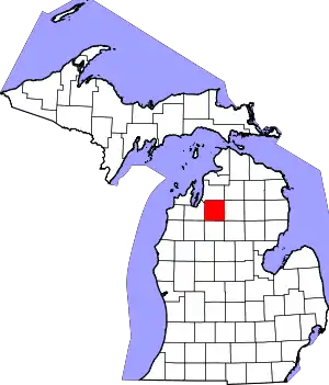 Map of Michigan highlighting Kalkaska County.svg | |
| Civil townships | ||
| CDPs | ||
| Other unincorporated communities | ||
| ||