Manono, Democratic Republic of the Congo
Manono is a town and territory in Tanganyika Province, Democratic Republic of the Congo.
Manono | |
|---|---|
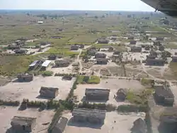 Manono from the air | |
 Manono | |
| Coordinates: 7.294704°S 27.454491°E | |
| Country | Democratic Republic of the Congo |
| Province | Tanganyika |
| Territory | Manono |
| Climate | Aw |
| National language | Swahili |
Location and economy
Manono lies on the western bank of the Lukushi, a tributary of the Luvua River. The town is a river port, with barges bringing cargo from Lubumbashi.[1] Manono is also connected to a disused railway line[1][2] to Muyumba[3]. Economic activity is centered on mining, with the surrounding area containing approximately 100 million tonnes of minerals, including spodumene (lithium), columbite, tin and tantalite.[1][4] The collapse of the world tin price in the 1980s severely hit the town's economy.[1] However, since 2017 exploration has been underway for lithium minerals and tin at the historical tin mine in the Manono - Kitotolo region with mining expected to commence in 2019 inclusive of hydrolelectric and road access upgrades...[5]
Climate
Manono has a tropical savanna climate (Köppen: Aw).
| Climate data for Manono | |||||||||||||
|---|---|---|---|---|---|---|---|---|---|---|---|---|---|
| Month | Jan | Feb | Mar | Apr | May | Jun | Jul | Aug | Sep | Oct | Nov | Dec | Year |
| Daily mean °C (°F) | 25.0 (77.0) |
25.2 (77.4) |
25.7 (78.3) |
25.8 (78.4) |
25.4 (77.7) |
24.2 (75.6) |
24.4 (75.9) |
25.5 (77.9) |
26.5 (79.7) |
26.1 (79.0) |
25.2 (77.4) |
24.8 (76.6) |
25.3 (77.5) |
| Average precipitation mm (inches) | 172 (6.8) |
146 (5.7) |
199 (7.8) |
122 (4.8) |
17 (0.7) |
2 (0.1) |
0 (0) |
6 (0.2) |
44 (1.7) |
90 (3.5) |
161 (6.3) |
181 (7.1) |
1,140 (44.7) |
| Source: Climate-Data.org[6] | |||||||||||||
Civil war
Manono was seriously affected by the Second Congo War (1998-2003), with many buildings destroyed. Rally for Congolese Democracy rebels and allied Rwandan soldiers took control of Manono in 1999.[7][8] A hydro-electric power plant used to provide electricity, however it was destroyed during the war. The town used to have a brewery which supplied the surrounding region, however it was destroyed during the war.[1]
Recent times
The UN carried out arms decommissioning in 2008, offering to accept guns in exchange for a bicycle. The scheme was successful in removing weapons.[9] The town is served by the Manono Airport.[10] Manono has a cathedral which was built by Belgian missionaries, and was severely damaged during the war.[1]
References
- "Beer and normality in DR Congo". BBC News. 2008-11-27. Retrieved 2009-03-23.
- National Geographic Atlas of the World: Revised Sixth Edition, National Geographic Society, 1992
- The Great Soviet Encyclopedia, 3rd Edition (1970-1979).
- "Manono, Katanga (Shaba), Democratic Republic of Congo (Zaïre)". mindat.org. Retrieved 2009-03-23.
- "Manono Project". AVZ Minerals Limited. Retrieved 2018-02-22.
- "Climate: Manono". Climate-Data.org. Retrieved 12 April 2014.
- "IRIN Update 688 for 8 June [19990608]". UN Office for the Coordination of Humanitarian Affairs. 1999-06-08. Retrieved 2009-03-23.
- "Southern African News Features". sardc.net. 2000-10-01. Archived from the original on 2013-02-22. Retrieved 2009-03-23.
- "The tragedy of Congo". guardian.co.uk. 2008-11-04. Retrieved 2009-03-23.
- "Manono Airport (MNO) Details - Democratic Republic Of Congo". world-airport-codes.com. Archived from the original on 2008-12-31. Retrieved 2009-03-23.