Mariato District
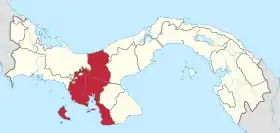
Created in 2001, Mariato District is a district (distrito) in the southeastern corner of Veraguas Province in Panama. The district seat is the town of Llano del Catival, also known simply as Mariato.
Mariato District | |
|---|---|
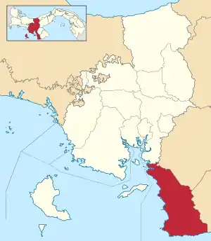 | |
 Mariato District Location of the district capital in Panama | |
| Coordinates: 7°39′N 81°0′W | |
| Country | |
| Province | Veraguas Province |
| Capital | Mariato |
| Region | Azuero |
| Area | |
| • Total | 533 sq mi (1,381 km2) |
| Population (2019) | |
| • Total | 5,564 |
| official estimate[1] | |
| Time zone | UTC-5 (ETZ) |
Geographically, the district totaling 1,381 km² comprises the west-facing coast of the Azuero peninsula fronting the Gulf of Montijo. It shares the peninsula with Los Santos and Herrera Province, separated by a crest of low mountains, the Macizo de Azuero. The highest peak is Cerro Hoya (1,559 m) in the far south.[2]
Punta Mariato at the southern tip of the district also holds the title as the southernmost point of North America.
Mariato is thinly populated with only 5,564 residents (2019 official estimate),[3] dispersed over 149 settlements. The district seat, Llano del Catival, is the largest population center with 2,490 people (2010), accounting for 43% of the entire district.[4]
Administrative divisions
Mariato District is divided administratively into the following corregimientos:
References
- Instituto Nacional de Estadística y Censo, Panama.
- "Parque Nacional Cerro Hoya". Archived from the original on 2011-09-29. Retrieved 2011-12-09.
- Instituto Nacional de Estadística y Censo, Panama.
- "Archived copy" (PDF). Archived from the original (PDF) on 2012-05-13. Retrieved 2011-12-08.CS1 maint: archived copy as title (link)