Marmaton Township, Bourbon County, Kansas
Marmaton Township is a township in Bourbon County, Kansas, USA. As of the 2000 census, its population was 815.
Marmaton Township | |
|---|---|
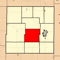 Location in Bourbon County | |
| Coordinates: 37°48′45″N 094°49′21″W | |
| Country | United States |
| State | Kansas |
| County | Bourbon |
| Area | |
| • Total | 56.11 sq mi (145.34 km2) |
| • Land | 56.04 sq mi (145.14 km2) |
| • Water | 0.08 sq mi (0.2 km2) 0.14% |
| Elevation | 820 ft (250 m) |
| Population (2000) | |
| • Total | 815 |
| • Density | 14.5/sq mi (5.6/km2) |
| GNIS feature ID | 0474758 |
History
Marmaton is a corruption of Marmiton, a French name given by fur traders meaning "scullion".[1]
Geography
Marmaton Township covers an area of 56.11 square miles (145.3 km2) and contains one city, Redfield, and the unincorporated community of Marmotan. According to the USGS, it contains two cemeteries: Marmaton and Woods.
The largest section of scenic Hollister Wildlife Area, containing portions of Pawnee Creek and Elm Creek, is located in the south. Bunion Creek, Cedar Creek, Chambers Branch, Paint Creek and Robinson Branch also run through the township.
Transportation
Marmaton Township is the site of Fort Scott Municipal Airport, a municipally-owned general aviation airport and landing strip.
Further reading
References
- Robley, T. F. (1894). History of Bourbon County, Kansas: To the Close of 1865. Press of the Monitor book & printing Company. pp. 98.
External links
- City-Data.com
- Bourbon County Maps: Current, Historic Collection
Municipalities and communities of Bourbon County, Kansas, United States | ||
|---|---|---|
| Cities | 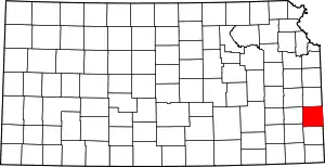 Map of Kansas highlighting Bourbon County | |
| Unincorporated communities | ||
| Townships | ||
| ||