Masonville, Colorado
Masonville is an unincorporated community and a U.S. Post Office in Larimer County, Colorado, United States. The Masonville Post Office has the ZIP Code 80541.[2]
Masonville, Colorado | |
|---|---|
 General store in Masonville | |
 Masonville Location in Colorado  Masonville Location in the United States | |
| Coordinates: 40°29′14″N 105°12′36″W | |
| Country | |
| State | |
| County | Larimer[1] |
| Elevation | 5,387 ft (1,642 m) |
| Time zone | UTC-7 (MST) |
| • Summer (DST) | UTC-6 (MDT) |
| ZIP code[2] | 80541 |
| Area code(s) | 970 |
| GNIS feature ID | 0204676 |
Geography
Masonville is located at 40°29′14″N 105°12′36″W (40.487171,-105.210056).
References
- "US Board on Geographic Names". United States Geological Survey. 2007-10-25. Retrieved 2008-01-31.
- "ZIP Code Lookup". United States Postal Service. January 2, 2007. Archived from the original (JavaScript/HTML) on November 23, 2010. Retrieved January 2, 2007.
Municipalities and communities of Larimer County, Colorado, United States | ||
|---|---|---|
| Cities | 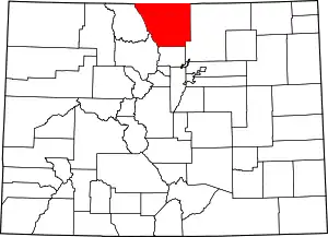 Map of Colorado highlighting Larimer County | |
| Towns | ||
| CDPs | ||
| Unincorporated communities | ||
| Ghost towns |
| |
| Footnotes | ‡This populated place also has portions in an adjacent county or counties | |
| ||
This article is issued from Wikipedia. The text is licensed under Creative Commons - Attribution - Sharealike. Additional terms may apply for the media files.