Matafao Peak
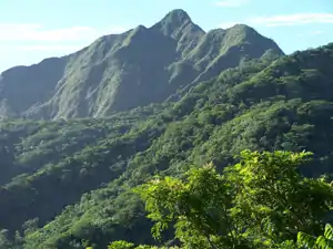
Matafao Peak (Samoan: Fa’asi’usi’uga o Matafao) is a mountain in American Samoa, on the island of Tutuila.[1][2] With an elevation of 653 meters (2,142 ft), it is the highest peak on Tutuila Island.[3][4] The mountain, like Rainmaker Mountain across Pago Pago Harbor, is a remnant of a volcanic plug and is part of the volcanic origins of the island. The mountain can be hiked from the high point of the Pago Pago-to-Fagasa Road. It is designated a National Natural Landmark above the 492-foot level,[5] an area known as Matafao Peak National Natural Landmark.
| Matafao Peak | |
|---|---|
 | |
| Highest point | |
| Elevation | 653 m (2,142 ft) |
| Prominence | 653 m (2,142 ft) |
| Coordinates | 14°17′41.64″S 170°42′7.92″W |
| Geography | |
 Matafao Peak | |
The name “Matafao” is said to refer to the fact that, from its peak, in fair weather, one can see as far as Mount Fao on Upolu Island.[6]
References
- U.S. Geological Survey Geographic Names Information System: Matafao Peak
- "Matafao Peak". Retrieved 13 April 2017.
- Schyma, Rosemarie (2013). Südsee. DuMont Reiseverlag. Page 260. ISBN 9783770176946.
- Hills, J.W. (2010). O upu muamua i le Tala i le Lalolagi mo e ua faatoa a'oa'oina u lea mataupu: Elementary Geography. Nabu Press. Page 59. ISBN 9781147952896.
- Swaney, Deanna (1994). Samoa: Western & American Samoa: a Lonely Planet Travel Survival Kit. Lonely Planet Publications. Pages 176-177. ISBN 9780864422255.
- Krämer, Augustin (2000). The Samoa Islands. University of Hawaii Press. Page 436. ISBN 9780824822194.
This article is issued from Wikipedia. The text is licensed under Creative Commons - Attribution - Sharealike. Additional terms may apply for the media files.
