Matamoros Municipality, Chihuahua
Matamoros is one of the 67 municipalities of Chihuahua, in northern Mexico. The municipal seat lies at Mariano Matamoros (aka "Villa Matamoros"). The municipality covers an area of 1,139.5 km².
Matamoros | |
|---|---|
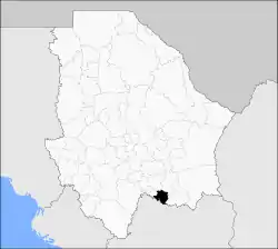 Municipality of Matamoros in Chihuahua | |
Matamoros Location in Mexico | |
| Coordinates: 26°45′49″N 105°34′56″W | |
| Country | |
| State | Chihuahua |
| Municipal seat | Mariano Matamoros |
| Area | |
| • Total | 1,139.5 km2 (440.0 sq mi) |
| Population (2010) | |
| • Total | 4,499 |
| • Density | 3.9/km2 (10/sq mi) |
As of 2010, the municipality had a total population of 4,499,[1] up from 4,304 as of 2005.[2]
The municipality had 109 localities, the largest of which (with 2010 population in parentheses) was: Mariano Matamoros (2,615), classified as urban.[1]
Geography
Towns and villages
The municipality has 46 localities. The largest are:
| Name | Population (2005) | |
|---|---|---|
| Mariano Matamoros | 2,256 | |
| El Veranito | 509 | |
| Santa Rosalía | 345 | |
| Ciénega de Ceniceros | 312 | |
| Total Municipality | 4,304 |
References
- "Matamoros". Catálogo de Localidades. Secretaría de Desarrollo Social (SEDESOL). Retrieved 23 April 2014.
- "Matamoros". Enciclopedia de los Municipios de México. Instituto Nacional para el Federalismo y el Desarrollo Municipal. Archived from the original on June 17, 2011. Retrieved October 13, 2008.
Chihuahua (capital) | ||
| Cities | 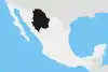 | |
| Municipalities | ||
| Metropolitan areas |
| |
| History | ||
| Sights | ||
| Other topics | ||
This article is issued from Wikipedia. The text is licensed under Creative Commons - Attribution - Sharealike. Additional terms may apply for the media files.