Matangi, New Zealand
Matangi (Māori: Mātangi) is a settlement in the Waikato District on the eastern border of Hamilton. It is surrounded by many lifestyle blocks, but the village centre has Matangi School (opened 1910, with 141 students and 6 teachers),[1] a garage, Four Square, takeaway and café, Matangi Hall, St David’s church and Matangi recreation reserve.[2]
Matangi | |
|---|---|
Village | |
 Matangi | |
| Coordinates: 37°49′S 175°25′E | |
| Elevation | 50 m (160 ft) |
| Population (2013 census) | |
| • Territorial | 2,157 |
| Time zone | UTC+12 (NZST) |
| • Summer (DST) | UTC+13 (NZDT) |
Demographics
Matangi had these census results:[3]
| Year | Population | Households | Average income |
|---|---|---|---|
| 2001 | 1,557 | 489 | $22,300 |
| 2006 | 1,791 | 597 | $29,100 |
| 2013 | 2,157 | 735 | $38,200 |
Geology
The area lies on Matangi soils,[4] formed on the edge of the Komakorau Bog and the Waikato's alluvial plains of sands and gravels.[5]
History
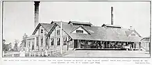
Sir George Grey Special Collections, Auckland Libraries, AWNS-19191120-38-1
The natural vegetation would have been mostly have been a mixed bush of totara, matai, rimu, kahikatea, titoki, tawa, and rewarewa. Virtually nothing remains of it.[6] Te Iti o Hauā marae, of Ngāti Haua, Ngāti Paretekawa and Ngāti Ngutu, is 3 km (1.9 mi) east of Matangi on Tauwhare Rd.[7] These original owners lost most of their land to confiscation or sales following the 1860s New Zealand wars.[8]
In 1884, the Cambridge branch opened with a station at Tamahere, renamed Matangi in 1906.[9] A creamery opened in 1885, then cheese factories and, in 1917, they amalgamated to form the New Zealand Dairy Association Group.[10] Further amalgamation followed and in 1919 New Zealand Co-operative Dairy Company Ltd opened its new dairy factory to produce dried milk for Glaxo. At the time it was the largest in the country, able to deal with 25,000 imp gal (110,000 l) a day.[11] It was an early customer of the Central Waikato Electric Power Board in 1921, when 12 local households were also connected.[12] From 1919 until its closure in 1987, the Matangi dairy factory also produced milk powder, condensed milk and cheese.[10]
Further rail sidings were added, along with a stationmaster and maintenance crews. In 1902, the first Matangi post office opened and in 1906, a telegram service was added, the school in 1910, bulk stores, marshalling yards and a community hall followed. After closure of the dairy factory, the post office and telephone exchange also closed.[2]
More recently, relaxation of subdivision rules have changed Matangi from a rural community to an area of rural residential development for Hamilton commuters.[13]
Marae
The local marae, Te Iti a Hauā Marae or Tauwhare Marae, is a meeting place of the Ngāti Hauā hapū of Ngāti Te Oro, Ngāti Te Rangitaupi, Ngāti Waenganui and Ngāti Werewere, and is affiliated with Waikato Tainui.[14] It includes the Hauā meeting house.[15]
In October 2020, the Government committed $734,311 from the Provincial Growth Fund to upgrade the marae and 4 other Ngāti Hauā marae, creating 7 jobs.[16]
Education
Matangi School is a co-educational state primary school,[17][18] with a roll of 184 as of March 2020.[19]
See also
Neighbouring areas | |
|---|---|
References
- "Welcome to Matangi School | Matangi School". www.matangi.school.nz. Retrieved 4 January 2016.
- "Matangi community". Waikato District Council.
- "2013 Census map – QuickStats about a place". www.stats.govt.nz. Retrieved 4 January 2016.
- "The Survey:- Soil Descriptions". www.nzsoils.org.nz. Retrieved 4 January 2016.
- Lowe, D. J. (2010). "Introduction to the landscapes and soils of the Hamilton Basin" (PDF).
- Theresa M. Downs, Bruce D. Clarkson, Beverley R. Clarkson (2007). "Indigenous Vegetation Types of Hamilton Ecological District" (PDF). Centre for Biodiversity and Ecology Research The University of Waikato.
- "Welcome to Māori Maps". www.maorimaps.com. Retrieved 4 January 2016.
- Taonga, New Zealand Ministry for Culture and Heritage Te Manatu. "Confiscation of Māori land". www.teara.govt.nz. Retrieved 4 January 2016.
- "Matangi Post Office". Waikato Argus. 17 June 1914. p. 2. Retrieved 7 January 2016.
- MOWBRAY, HARRY and ANDREW (2004). "MATANGI FACTORY HISTORIC PLACES TRUST RESTORATION PROPOSAL". Waikato District Council.
- "Dried Milk Industry". New Zealand Herald. 13 November 1919. p. 8. Retrieved 2 January 2016.
- Gilson, Chris (2005). Wiring up the Waikato. WEL Networks.
- Wright, Jason (2006). "Change in local places: the experience of a peri-urban community" (PDF). Department of Geography University of Waikato.
- "Te Kāhui Māngai directory". tkm.govt.nz. Te Puni Kōkiri.
- "Māori Maps". maorimaps.com. Te Potiki National Trust.
- "Marae Announcements" (Excel). growregions.govt.nz. Provincial Growth Fund. 9 October 2020.
- "Official School Website". matangi.school.nz.
- "Ministry of Education School Profile". educationcounts.govt.nz. Ministry of Education.
- "Education Review Office Report". ero.govt.nz. Education Review Office.