Matauri Bay
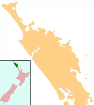
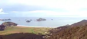
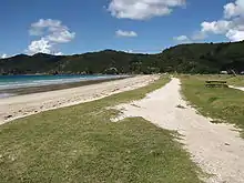
Matauri Bay (Māori: Mātauri) is a bay in New Zealand, situated 30 km north of Kerikeri, in Whangaroa county, just north of the Bay of Islands. It has over a kilometre of white sand and crystal clear water, making it a popular summer destinations for surfers, divers, fishers and holidymakers.
Demographics
| Year | Pop. | ±% p.a. |
|---|---|---|
| 2006 | 1,104 | — |
| 2013 | 1,026 | −1.04% |
| 2018 | 1,344 | +5.55% |
| Source: [1] | ||
The statistical area of Whakarara, which at 169.49 square km is much larger than this locality, covers the area east of Whangaroa Harbour. Whakarara had a population of 1,344 at the 2018 New Zealand census, an increase of 318 people (31.0%) since the 2013 census, and an increase of 240 people (21.7%) since the 2006 census. There were 465 households. There were 663 males and 678 females, giving a sex ratio of 0.98 males per female. Of the total population, 273 people (20.3%) were aged up to 15 years, 207 (15.4%) were 15 to 29, 588 (43.8%) were 30 to 64, and 273 (20.3%) were 65 or older. Figures may not add up to the total due to rounding.
Ethnicities were 56.7% European/Pākehā, 58.9% Māori, 4.2% Pacific peoples, 1.8% Asian, and 1.3% other ethnicities. People may identify with more than one ethnicity.
The percentage of people born overseas was 11.4, compared with 27.1% nationally.
Although some people objected to giving their religion, 43.3% had no religion, 35.0% were Christian, and 12.7% had other religions.
Of those at least 15 years old, 126 (11.8%) people had a bachelor or higher degree, and 249 (23.2%) people had no formal qualifications. The median income was $21,900. The employment status of those at least 15 was that 387 (36.1%) people were employed full-time, 198 (18.5%) were part-time, and 57 (5.3%) were unemployed.[1]
History and culture
Early history
Some of the first Polynesian navigators to New Zealand landed at Matauri Bay. It was a site of early Maori contact with Europeans, such as with the missionary Samuel Marsden in 1814.
Rainbow Warrior
The Rainbow Warrior was given a final resting place near Matauri Bay, at the Cavalli Islands. It has become a living reef, attracting marine life and recreational divers.
The idea was first proposed by the New Zealand Underwater Association. It seemed a fitting end for a ship that had spent its time protecting the marine environment.
It was towed north with a patched hull on 2 December 1987. Ten days later, a crowd of well-wishers looked on as it was given a traditional Māori burial. Now home to a complex ecosystem, the Rainbow Warrior has become a popular dive destination. The local Māori community maintains its guardianship and conservation. In a few years, the Rainbow Warrior became an integral part of the environment it helped protect.
Marae
The Matauri Bay area has two marae. Mātauri or Te Tāpui Marae and Ngāpuhi meeting house is a meeting place of the Ngāpuhi hapū of Ngāti Kura and Ngāti Miru, and the Ngāpuhi / Ngāti Kahu ki Whaingaroa hapū of Ngāti Kura. Te Ngaere Marae and Ngāi Tupango te Hapū meeting house is a meeting place of the Ngāpuhi / Ngāti Kahu ki Whaingaroa hapū of Ngaitupango.[2][3]
Education
Matauri Bay School is a contributing primary (years 1-6) school[4] with a roll of 72 students as of March 2020.[5] It opened in 1954.
Te Kura Kaupapa Māori o Whangaroa is a composite (years 1-13) school[6] with a roll of 50 students as of March 2020.[5] It is a Kura Kaupapa Māori school which teaches fully in the Māori language.
Both schools are coeducational.
A Māori school was established at Te Ngaere in 1876, but student numbers fluctuated as local people moved to seek an income on the gumfields. In 1890, attendance at the school ceased, and the building was dragged to the top of the hill by a bullock team to make it more accessible. Changing its name to Whakarara School, it remained open until Matauri Bay School replaced it.[7]
Notes
| Wikimedia Commons has media related to Matauri Bay. |
- "Statistical area 1 dataset for 2018 Census". Statistics New Zealand. March 2020. Whakarara (101800). 2018 Census place summary: Whakarara
- "Te Kāhui Māngai directory". tkm.govt.nz. Te Puni Kōkiri.
- "Māori Maps". maorimaps.com. Te Potiki National Trust.
- Education Counts: Matauri Bay School
- "New Zealand Schools Directory". New Zealand Ministry of Education. Retrieved 26 April 2020.
- Education Counts: Te Kura Kaupapa Māori o Whangaroa
- Sale, E. V. (1986). Whangaroa. p. 136. ISBN 0-473-00387-2.