Matsuzaki, Shizuoka
Matsuzaki (松崎町, Matsuzaki-chō) is a town located in on the southwest coast of Izu Peninsula in Kamo District, Shizuoka Prefecture, Japan. As of 31 July 2019, the town had an estimated population of 6,563 in 2969 households,[1] and a population density of 77 persons per km². The total area of the town is 85.23 square kilometres (32.91 sq mi). Sakuramochi is a noted local specialty. Matsuzaki is listed as one of The Most Beautiful Villages in Japan.[2]
Matsuzaki
松崎町 | |
|---|---|
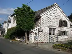 Namakokabe-style house typical of Matsuzaki | |
 Flag  Seal | |
| |
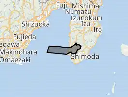
 Location of Matsuzaki in Shizuoka Prefecture | |
 Matsuzaki | |
| Coordinates: 34°45′N 138°47′E | |
| Country | Japan |
| Region | Chūbu Tōkai |
| Prefecture | Shizuoka |
| District | Kamo |
| Area | |
| • Total | 85.23 km2 (32.91 sq mi) |
| Population (July 31, 2019) | |
| • Total | 6,563 |
| • Density | 77/km2 (200/sq mi) |
| Time zone | UTC+9 (Japan Standard Time) |
| - Tree | Pine |
| - Flower | Farfugium |
| Phone number | 0558-42-1111 |
| Address | 301-1 Miyauchi, Matsuzaki-chō, Kamo-gun, Shizuoka-ken 410-3696 |
| Website | Official website |
Geography
Matsuzaki is located on the southwest coast of Izu Peninsula, facing Suruga Bay on the Pacific Ocean. It is a hilly region with an indented ria coastline. The area has numerous hot springs. Warmed by the warm Kuroshio Current, the area enjoys a warm maritime climate with hot, humid summers and mild, cool winters. Parts of the town are within the borders of Fuji-Hakone-Izu National Park.
Demographics
Per Japanese census data,[3] the population of Matsuzaki has been in slow decline over the past 50 years.
| Year | Pop. | ±% |
|---|---|---|
| 1940 | 11,480 | — |
| 1950 | 14,162 | +23.4% |
| 1960 | 12,183 | −14.0% |
| 1970 | 10,425 | −14.4% |
| 1980 | 10,013 | −4.0% |
| 1990 | 9,266 | −7.5% |
| 2000 | 8,515 | −8.1% |
| 2010 | 7,642 | −10.3% |
Climate
The city has a climate characterized by hot and humid summers, and relatively mild winters (Köppen climate classification Cfa). The average annual temperature in Matsuzaki is 16.4 °C. The average annual rainfall is 2035 mm with September as the wettest month. The temperatures are highest on average in August, at around 26.6 °C, and lowest in January, at around 7.1 °C.[4]
History
During the Edo period, all of Izu Province was tenryō territory under direct control of the Tokugawa shogunate, and the area now comprising Matsuzaki Town consisted of 21 villages. With the establishment of the modern municipalities system of the early Meiji period in 1889, the area was divided into 11 villages within Kamo District, and 10 villages within Naka District. After the abolishment of Naka District, all 21 villages were reunited under Kamo District. Matsuzaki Village was elevated to town status in 1901. The town annexed neighboring Nakagawa Village in 1955 and Iwashina Village in 1956.
Around March 31, 2010, the city of Shimoda and three municipalities in Kamo District (Kawazu, Matsuzaki, and Minamiizu) were scheduled to merge.[5] However, the merger backed out.
Economy
The economy of Matsuzaki is dominated by commercial fishing, forestry and the tourist industry centered on hot spring resorts. Some 64% of the area is forest.
Education
Matsuzaki has one public elementary school and one public junior high school operated by the town government. The town has one public high school operated by the Shizuoka Prefectural Board of Education.
Transportation
Highway
Notable people from Matsuzaki
- Irie Chōhachi - artist
- Kondō Heisaburō - pharmacologist
- Yoda Benzō - Hokkaido pioneer
- Rentarō Mikuni - actor
Gallery
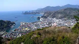 Downtown Matsuzaki
_s2.jpg.webp) Port of Kumomi and Mount Eboshi
Port of Kumomi and Mount Eboshi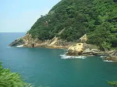 Matsuzaki Kumomi shoreline
 Iwachi shore (岩地海岸), also dubbed "Izu Côte d'Azur", in Matsuzaki
References
- Matsuzaki Town official statistics (in Japanese)
- The Most Beautiful Villages in Japan Archived 2015-02-15 at the Wayback Machine (in Japanese)
- Matsuzaki population statistics
- Matsuzaki climate data
- "Archived copy". Archived from the original on 2007-07-28. Retrieved 2008-09-08.CS1 maint: archived copy as title (link)
External links
![]() Media related to Matsuzaki, Shizuoka at Wikimedia Commons
Media related to Matsuzaki, Shizuoka at Wikimedia Commons
- Matsuzaki official website (Japanese)
 Geographic data related to Matsuzaki, Shizuoka at OpenStreetMap
| Shizuoka |
| |||
|---|---|---|---|---|
| Hamamatsu |
| |||
| Special cities | ||||
| Cities | ||||
| Districts | ||||
| Authority control |
|---|