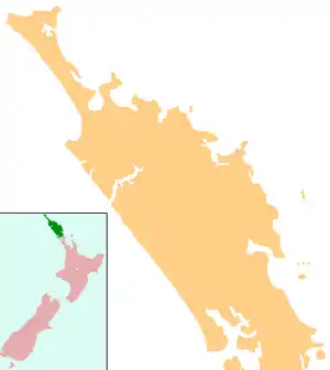
Maungaturoto
Maungaturoto is a small town in the Northland Region of New Zealand.
Maungaturoto | |
|---|---|
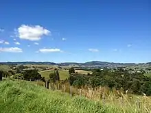
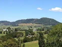 View from the hills of Maungaturoto | |
 Maungaturoto | |
| Coordinates: 36°06′35″S 174°21′15″E | |
| Country | New Zealand |
| Region | Northland Region |
| District | Kaipara District |
| Population (2018) | |
| • Total | 1,269 |
The township is located close to the Otamatea River, an estuarial arm of the Kaipara Harbour 25 kilometres north of Wellsford and 45 kilometres south of Whangarei.
The New Zealand Ministry for Culture and Heritage gives a translation of "mountain standing up in lagoons" for Maungatūroto.[1]
Demographics
| Year | Pop. | ±% p.a. |
|---|---|---|
| 2006 | 1,113 | — |
| 2013 | 1,089 | −0.31% |
| 2018 | 1,269 | +3.11% |
| Source: [2] | ||
Maungaturoto had a population of 1,269 at the 2018 New Zealand census, an increase of 180 people (16.5%) since the 2013 census, and an increase of 156 people (14.0%) since the 2006 census. There were 450 households. There were 639 males and 630 females, giving a sex ratio of 1.01 males per female. Of the total population, 291 people (22.9%) were aged up to 15 years, 234 (18.4%) were 15 to 29, 510 (40.2%) were 30 to 64, and 231 (18.2%) were 65 or older. Figures may not add up to the total due to rounding.
Ethnicities were 85.8% European/Pākehā, 23.4% Māori, 2.8% Pacific peoples, 2.4% Asian, and 0.9% other ethnicities. People may identify with more than one ethnicity.
The percentage of people born overseas was 12.3, compared with 27.1% nationally.
Although some people objected to giving their religion, 43.0% had no religion, 42.1% were Christian, and 5.2% had other religions.
Of those at least 15 years old, 87 (8.9%) people had a bachelor or higher degree, and 222 (22.7%) people had no formal qualifications. The median income was $24,100. The employment status of those at least 15 was that 438 (44.8%) people were employed full-time, 147 (15.0%) were part-time, and 30 (3.1%) were unemployed.[2]
Education
Otamatea High School is a secondary (years 7–13) school with a roll of 432 students.[3] The school celebrated its 50th reunion in 2016.[4] The District High School was established in Maungaturoto in 1939.[5] Otamatea High School won the Goodman Fielder Composite School of the Year Award in 2000. [6]
Maungaturoto School is a contributing primary (years 1-6) school with a roll of 225 students.[7] A school first opened in Maungaturoto in 1874.[8]
Otamatea Christian School is a composite state-integrated (years 1–13) school with a roll of 28 students.[9]
All these schools are coeducational. Rolls are as of March 2020.[10]
Notes
- "1000 Māori place names". New Zealand Ministry for Culture and Heritage. 6 August 2019.
- "Statistical area 1 dataset for 2018 Census". Statistics New Zealand. March 2020. Maungaturoto (109600). 2018 Census place summary: Maungaturoto
- Education Counts: Otamatea High School
- "Otamatea High School and Maungaturoto District High School 50th Reunion 2016" (PDF). Retrieved 15 July 2016.
- Ryburn, Wayne (1999). Tall Spars, Steamers & Gum. Auckland, N.Z.: Kaipara Publications. p. 167. ISBN 0-473-06176-7.
- "Welcome to Maungaturoto Information Pack" (PDF). Real Town Maungaturoto Inc. p. 3. Archived from the original (PDF) on 24 July 2011. Retrieved 19 November 2010.
- Education Counts: Maungaturoto School
- Ryburn, p 222
- Education Counts: Otamatea Christian School
- "New Zealand Schools Directory". New Zealand Ministry of Education. Retrieved 26 April 2020.