McDonald, Kansas
McDonald is a city in Rawlins County, Kansas, United States. As of the 2010 census, its population was 160.[6]
McDonald, Kansas | |
|---|---|
 Location within Rawlins County and Kansas | |
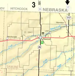 KDOT map of Rawlins County (legend) | |
| Coordinates: 39°47′7″N 101°22′14″W | |
| Country | United States |
| State | Kansas |
| County | Rawlins |
| Founded | 1880s |
| Incorporated | 1919 |
| Named for | Rice McDonald |
| Area | |
| • Total | 0.22 sq mi (0.57 km2) |
| • Land | 0.22 sq mi (0.57 km2) |
| • Water | 0.00 sq mi (0.00 km2) |
| Elevation | 3,363 ft (1,025 m) |
| Population | |
| • Total | 160 |
| • Estimate (2019)[3] | 157 |
| • Density | 716.89/sq mi (276.57/km2) |
| Time zone | UTC-6 (CST) |
| • Summer (DST) | UTC-5 (CDT) |
| ZIP code | 67745 |
| Area code | 785 |
| FIPS code | 20-43750 [4] |
| GNIS ID | 0470987 [5] |
History
A post office was opened in Celia (an extinct town) in 1880, but it was moved to McDonald in 1888.[7] McDonald was named for Rice McDonald, a landowner.[8]
Geography
McDonald is located at 39°47′7″N 101°22′14″W (39.785196, -101.370435).[9] According to the United States Census Bureau, the city has a total area of 0.22 square miles (0.57 km2), all land.[10]
Climate
According to the Köppen Climate Classification system, McDonald has a semi-arid climate, abbreviated "BSk" on climate maps.[11]
According weather data tallied between July 1, 1985 and June 30, 2015 for every location in the National Oceanic and Atmospheric Administration's official climate database, McDonald, Kansas, is the snowiest place in the state of Kansas with an average of 37.6 inches of snow per year. [12]
Demographics
| Historical population | |||
|---|---|---|---|
| Census | Pop. | %± | |
| 1920 | 341 | — | |
| 1930 | 442 | 29.6% | |
| 1940 | 425 | −3.8% | |
| 1950 | 426 | 0.2% | |
| 1960 | 225 | −47.2% | |
| 1970 | 269 | 19.6% | |
| 1980 | 239 | −11.2% | |
| 1990 | 184 | −23.0% | |
| 2000 | 159 | −13.6% | |
| 2010 | 160 | 0.6% | |
| 2019 (est.) | 157 | [3] | −1.9% |
| U.S. Decennial Census | |||
2010 census
As of the census[2] of 2010, there were 160 people, 77 households, and 48 families residing in the city. The population density was 727.3 inhabitants per square mile (280.8/km2). There were 98 housing units at an average density of 445.5 per square mile (172.0/km2). The racial makeup of the city was 97.5% White, 0.6% Native American, 0.6% from other races, and 1.3% from two or more races. Hispanic or Latino of any race were 11.3% of the population.
There were 77 households, of which 16.9% had children under the age of 18 living with them, 50.6% were married couples living together, 7.8% had a female householder with no husband present, 3.9% had a male householder with no wife present, and 37.7% were non-families. 32.5% of all households were made up of individuals, and 16.9% had someone living alone who was 65 years of age or older. The average household size was 2.08 and the average family size was 2.63.
The median age in the city was 53.5 years. 18.1% of residents were under the age of 18; 6.3% were between the ages of 18 and 24; 14.5% were from 25 to 44; 35.7% were from 45 to 64; and 25.6% were 65 years of age or older. The gender makeup of the city was 50.0% male and 50.0% female.
2000 census
As of the census[4] of 2000, there were 159 people, 80 households, and 46 families residing in the city. The population density was 864.9 people per square mile (341.1/km2). There were 109 housing units at an average density of 592.9 per square mile (233.8/km2). The racial makeup of the city was 99.37% White and 0.63% Native American.
There were 80 households, out of which 18.8% had children under the age of 18 living with them, 53.8% were married couples living together, 2.5% had a female householder with no husband present, and 42.5% were non-families. 40.0% of all households were made up of individuals, and 27.5% had someone living alone who was 65 years of age or older. The average household size was 1.99 and the average family size was 2.63.
In the city, the population was spread out, with 19.5% under the age of 18, 3.8% from 18 to 24, 18.9% from 25 to 44, 28.3% from 45 to 64, and 29.6% who were 65 years of age or older. The median age was 49 years. For every 100 females, there were 89.3 males. For every 100 females age 18 and over, there were 85.5 males.
The median income for a household in the city was $30,139, and the median income for a family was $32,083. Males had a median income of $23,125 versus $33,125 for females. The per capita income for the city was $15,790. About 13.3% of families and 11.8% of the population were below the poverty line, including 8.8% of those under the age of eighteen and 21.1% of those 65 or over.
Education
McDonald is served by USD 103 Cheylin.[13] School unification consolidated Bird City and McDonald schools in 1975 creating USD 103.[14] The Cheylin High School mascot is Cheylin Cougars.
McDonald High School was closed through school unification. The McDonald High School mascot was Tigers.[15]
References
- "2019 U.S. Gazetteer Files". United States Census Bureau. Retrieved July 24, 2020.
- "U.S. Census website". United States Census Bureau. Retrieved 2012-07-06.
- "Population and Housing Unit Estimates". United States Census Bureau. May 24, 2020. Retrieved May 27, 2020.
- "U.S. Census website". United States Census Bureau. Retrieved 2008-01-31.
- "US Board on Geographic Names". United States Geological Survey. 2007-10-25. Retrieved 2008-01-31.
- "2010 City Population and Housing Occupancy Status". U.S. Census Bureau. Retrieved September 1, 2011.
- "Kansas Post Offices, 1828-1961". Kansas Historical Society. Archived from the original on 9 October 2013. Retrieved 22 June 2014.
- "Profile for McDonald, Kansas". ePodunk. Archived from the original on 4 March 2016. Retrieved 22 June 2014.
- "US Gazetteer files: 2010, 2000, and 1990". United States Census Bureau. 2011-02-12. Retrieved 2011-04-23.
- "US Gazetteer files 2010". United States Census Bureau. Archived from the original on January 12, 2012. Retrieved 2012-07-06.
- Climate Summary for McDonald, Kansas
- "The Snowiest Place in Each State". Retrieved 2015-01-24.
- "Cheylin USD 103". USD 103. Retrieved 7 January 2017.
- "Cheylin provides new name in Liberty loop", The Salina Journal, 7 September 1975, p..
- "McDonald Had Fine Season", The Salina Journal, 16 March 1960, p.10.
Further reading
External links
- City
- Photos
- Maps
- McDonald City Map, KDOT
Municipalities and communities of Rawlins County, Kansas, United States | ||
|---|---|---|
| Cities | 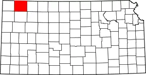 Map of Kansas highlighting Rawlins County | |
| Unincorporated communities | ||
| Ghost town | ||
| ||
| Authority control |
|---|