Mead Township, Warren County, Pennsylvania
Mead Township is a township in Warren County, Pennsylvania, United States. The population was 1,555 at the 2000 census.
Mead Township | |
|---|---|
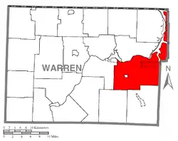 Location of Mead Township in Warren County | |
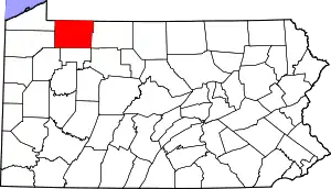 Location of Warren County in Pennsylvania | |
| Country | United States |
| State | Pennsylvania |
| County | Warren County |
| Area | |
| • Total | 85.64 sq mi (221.80 km2) |
| • Land | 78.59 sq mi (203.54 km2) |
| • Water | 7.05 sq mi (18.26 km2) |
| Population (2010) | |
| • Total | 1,386 |
| • Estimate (2018)[2] | 1,311 |
| • Density | 16.87/sq mi (6.51/km2) |
| Time zone | UTC-4 (EST) |
| • Summer (DST) | UTC-5 (EDT) |
| Area code(s) | 814 |
History
Mead Township was created on June 7, 1847 from parts of Sheffield, Kinzua, and Pleasant Townships. It was named for early 19th-century settler Darius Mead.[3]
In the early 1960s, construction began on the Kinzua Dam and a few small communities on the banks of the Allegheny River were evacuated and flooded. The nearby townships of Kinzua and Corydon, having greatly reduced populations, were merged into Mead in 1963 and 1964, respectively.[4]
Geography
According to the United States Census Bureau, the township has a total area of 85.8 square miles (222.1 km2), of which, 78.5 square miles (203.3 km2) of it is land and 7.2 square miles (18.8 km2) of it (8.45%) is water. It is the largest township by area in Warren County.
The Allegheny Reservoir forms the entire western border of Mead Township's northern arm.
The Borough of Clarendon is enclaved within the Township.
Demographics
| Historical population | |||
|---|---|---|---|
| Census | Pop. | %± | |
| 2010 | 1,386 | — | |
| 2018 (est.) | 1,311 | [2] | −5.4% |
| U.S. Decennial Census[5] | |||
As of the census[6] of 2000, there were 1,555 people, 649 households, and 456 families residing in the township. The population density was 19.8 people per square mile (7.6/km2). There were 878 housing units at an average density of 11.2/sq mi (4.3/km2). The racial makeup of the township was 99.10% White, 0.06% African American, 0.06% Asian, 0.06% Pacific Islander, and 0.71% from two or more races. Hispanic or Latino of any race were 0.26% of the population.
There were 649 households, out of which 27.4% had children under the age of 18 living with them, 57.6% were married couples living together, 7.4% had a female householder with no husband present, and 29.7% were non-families. 25.9% of all households were made up of individuals, and 11.2% had someone living alone who was 65 years of age or older. The average household size was 2.39 and the average family size was 2.84.
In the township the population was spread out, with 22.3% under the age of 18, 6.8% from 18 to 24, 27.0% from 25 to 44, 27.7% from 45 to 64, and 16.3% who were 65 years of age or older. The median age was 42 years. For every 100 females, there were 101.7 males. For every 100 females age 18 and over, there were 96.9 males.
The median income for a household in the township was $37,443, and the median income for a family was $41,875. Males had a median income of $32,109 versus $24,896 for females. The per capita income for the township was $17,792. About 6.5% of families and 11.0% of the population were below the poverty line, including 17.5% of those under age 18 and 3.3% of those age 65 or over.
References
- "2016 U.S. Gazetteer Files". United States Census Bureau. Retrieved Aug 14, 2017.
- Bureau, U. S. Census. "U.S. Census website". United States Census Bureau. US Census Bureau. Retrieved 13 August 2019.
- Miller, Ernest C. "Place Names in Warren County, Pennsylvania." The Western Pennsylvania Historical Magazine Apr. 1971.
- Hoover, William N (2006). Kinzua: From Cornplanter to the Corps. Lincoln, Nebraska: iUniverse. p. 12. ISBN 0-595-82483-8.
- "Census of Population and Housing". Census.gov. Retrieved June 4, 2016.
- "U.S. Census website". United States Census Bureau. Retrieved 2008-01-31.
Municipalities and communities of Warren County, Pennsylvania, United States | ||
|---|---|---|
| City | | |
| Boroughs | ||
| Townships | ||
| CDPs | ||
| Unincorporated communities | ||
| Ghost towns | ||
| Footnotes | ‡This populated place also has portions in an adjacent county or counties | |
| ||