Metaline Falls-Nelway Border Crossing
The Metaline Falls–Nelway Border Crossing connects the town of Metaline Falls, Washington with Nelson, British Columbia at the Canada–US border. Access is via Washington State Route 31 on the American side and British Columbia Highway 6 on the Canadian side.
| Metaline Falls-Nelway Crossing | |
|---|---|
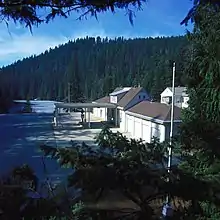
 Canada Border Inspection Station at Nelway, BC | |
| Location | |
| Country | United States; Canada |
| Location |
|
| Coordinates | 48.999979°N 117.299706°W |
| Details | |
| Opened | 1921 |
| US Phone | (509) 446-4421 |
| Canadian Phone | (250) 357-9940 |
| Hours | 8:00AM - 8:00PM |
| Website https://www.cbp.gov/border-security/along-us-borders/border-patrol-sectors/spokane-sector-washington/metaline-falls-station | |
U.S. Border Station | |
| NRHP reference No. | 96001634 |
| Added to NRHP | January 31, 1997 |
The popular belief is that Nelway is a contraction of "Nelson and Spokane highway," but could be for Nelson and Fort Sheppard Railway, which passed in the vicinity.[1] Canada has had a customs office in the Nelson area since 1900, but this particular crossing did not exist until the Pend Oreille Highway was completed in 1921. The highway on the BC side officially opened in 1923, but the name Nelway did not appear until 1926.[1]
The BC part of the highway was subject to criticism for decades because the road was narrow, winding and rough,[2] making travel slow and difficult.[3] To handle increasing traffic, sections were progressively realigned and paved from 1948,[4] and throughout the following decade.
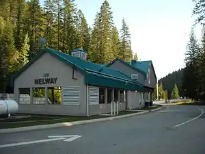
The US still occupies the original permanent border station at this crossing, built in the mid-1930s; it was recorded on the U.S. National Register of Historic Places in 1997.[5] Canada replaced its depression-era border station in 1951, then replaced it again in 2000. Today the crossing is often used by tourists exploring the International Selkirk Loop.[6]
References
- "Nelson Star, 19 Mar 2016". www.nelsonstar.com.
- "Province, 23 Sep 1928". www.newspapers.com. p. 42.
From Nelson to Salmo, the highway is in fair shape, but from Salmo to Nelway, it is prevailingly narrow, tortuous and rough.
- "Vancouver Sun, 13 Jul 1935". www.newspapers.com. p. 22.
….border station at Nelway on the way south. Highways on the U.S. side of the line are worthy of the name, permitting rapid transit in comfort, while those on the B.C. side are narrow badly surfaced, and in many places, improperly laid out.
- "Vancouver Sun, 29 Jul 1949". www.newspapers.com. p. 21.
Large increase in tourist travel….on Nelson-Nelway link, part of which was paved last year. Travel on it is up 60 percent over 1948….
- "United States Border Station, Metaline Falls". www.nps.gov.
- "The International Selkirk Loop". www.selkirkloop.org.